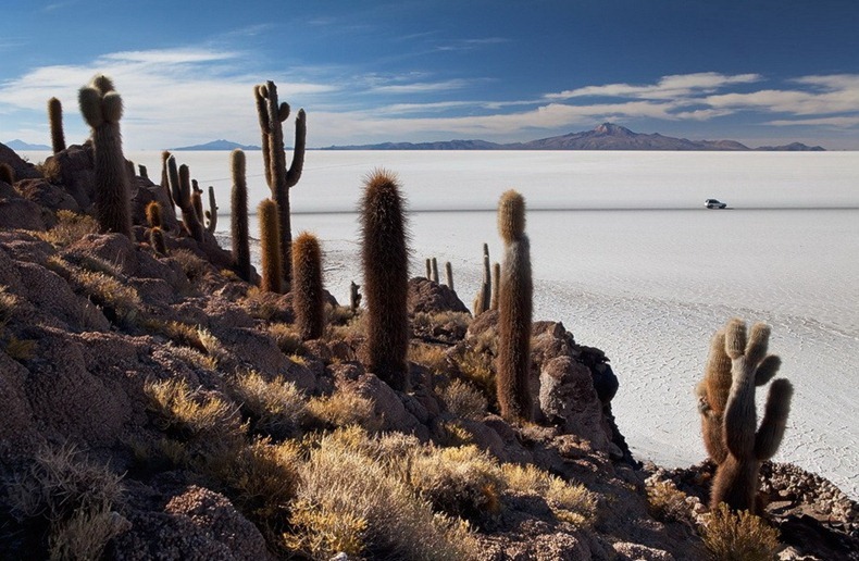
Salar de Uyuni: World’s Largest Salt Flat

Salar de Uyuni (or Salar de Tunupa), located in southwest Bolivia, near the crest of the Andes, is one of the most visually captivating place in South America. Photographers flock here everyday to capture the stunning landscape created by amazing geological formations, geothermal springs and brine lakes. Covering an area of 10,582 square kilometers, it is the world's largest salt flat. Salar de Uyuni is estimated to have a reserve of 10 billion tons of salt.

Some 30 to 40 thousand years ago, this area was part of a giant prehistoric lake called Lake Minchin. The lake underwent a series of transformation between several vast lakes, and when it dried, it left behind two modern lakes, Poopó Lake and Uru Uru Lake, and two major salt deserts, Salar de Coipasa and the larger Salar de Uyuni.


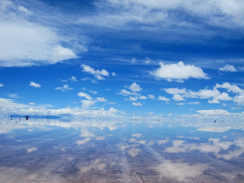
In the dry season, the salt planes are completely flat expanses of dry salt, but during the wet season, the neighboring Lake Poopó overflows and floods Salar De Coipasa and Salar de Uyuni covering both deserts with a thin sheet of water that looks magnificent under the vast open sky.

Underneath the surface of the Salar is a lake of brine 2 to 20 meters deep. The lake is covered with a solid salt crust with a thickness varying between tens of centimeters to a few meters. The center of the Salar contains a few "islands", which are the remains of the tops of ancient volcanoes which were submerged during the era of lake Minchin. They include unusual and fragile coral-like structures and deposits that often consist of fossils and algae.
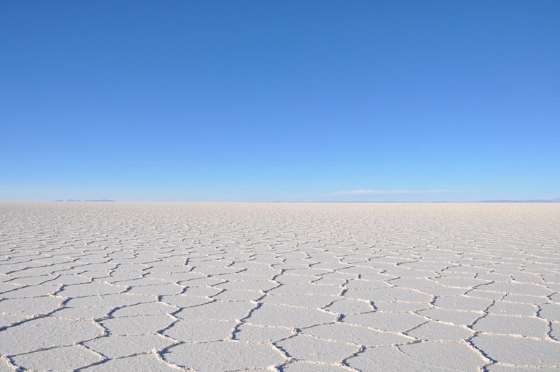


The Land Rover G4 Challenge of 2006 staged in Salar de Uyuni


In the wet season, the Poopó Lake overflows into Salar de Uyuni turning it into the worlds largest mirror.



The Salar contains large amounts of sodium, potassium, lithium and magnesium as well as borax. With estimated 5,400,000 tonnes, Bolivia holds about half of the world's lithium reserves, most of those are located in the Salar de Uyuni. Despite the large reserve, there is currently no mining plant at the site, as the Bolivian government doesn't want to allow exploitation by foreign corporations. Instead, it intends to build its own pilot plant with a modest annual production by 2012.

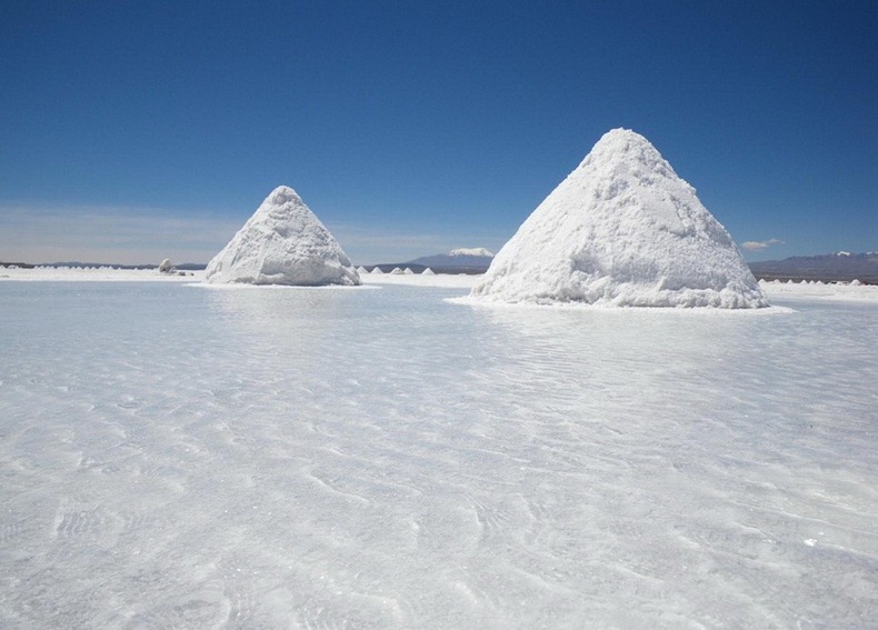
Salar de Uyuni is estimated to contain 10 billion tonnes of salt, of which less than 25,000 tonnes is extracted annually.






Salt Hotels
Salar de Uyuni attracts tourists from around the world. As it is located far from the cities, a number of hotels have been built for accommodation. Due to lack of conventional construction materials, many of them are almost entirely built with salt blocks cut from the Salar - including walls, roof and furniture. The first such hotel, Hotel de Sal Playa, was erected in 1993-1995 in the middle of the salt flat, and soon became a popular tourist destination. Many more hotels and hostels made out of salt were constructed later.
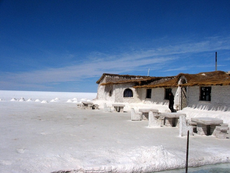


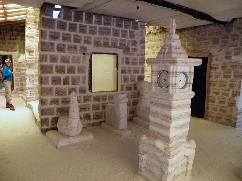

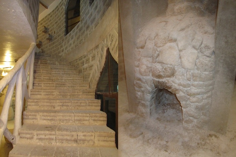


The Salar is virtually devoid of any wild life and vegetation, except by giant cacti that grow at a rate of about 1 centimeter per year to a length of about 12 meters. A few shrubs and bushes are scattered along the plains.

Salar de Uyuni is also the breeding grounds for pink South American flamingos, their color presumably originating from feeding on pink algae. There are about 80 of other bird species present, including the horned coot, the Andean goose and the Andean Hillstar.


Source


READ MORE»

Marvellous Star Beings Discovered In Galactic Clouds

The ancients spoke of them and the Indian texts alluded to them: the gods in the stars fashioning the universe with their unworldly powers. Now an intrepid researcher has plumbed the depths of the infinite galactic night to extract hidden information once thought beyond the grasp of Mankind's intellect.


Technology of the gods visible within Orion's belt

Mystical images from interstellar space
The images accompanying this article have undergone the same fractal imaging process employed in gleaning hidden messages and data from ice crystals in the back yard of a man who photographed them with his high resolution digital camera.

These images, processed through Photoshop and interpolated to reveal hidden energies cloaked within nebulae and star dust, present a powerful testament that supports the writings of the ancients, their belief in the powerful beings that shape the universe, and the panoply of super-advanced races (maybe billions of years older than humans), that stride the galactic night turning starstuff into planets.


A Tibetan temple built at 'the top of the world'

The astounding memory crystals of Tibet
Famous mythologist William Henry who studied the myths and traditions of many peoples of the Far East once spent time in Tibet researching the holy Llamas and their teaching of the divine beings that dwell among the stars.

Henry related one of the Tibetan tales that tells of "a divine couple [who] once appeared who hid secret teachings in 'diamond rocks, in mysterious lakes, and in unchanging boxes' that were magically closed until a special time in history. Many texts were compressed in these diamond rocks or crystals similar to the way information is inscribed onto and 'hidden' in modern microchips or CD Rom disks.


Revealed: the crowning glory of the alien masters

"This fascinating Tibetan tradition is called 'terma.' Termas, or 'concealed treasures,' are sacred texts or holy objects hidden in a paradise of eternal universal wisdom and peace. Complimenting the terma tradition is the Tibetan practice of 'dzogchen,' an ancient teaching in which hand-held conical-shaped quartz crystals were used for meditation purposes. It was believed that these objects connected their user with the creative forces of the universe, the basic forces of life."


Blue Kachina doll of the Pueblo represents a star being

Further descriptions concerning the use of these memory crystals that contained stored knowledge revealed that information was stored into them with light and that a user's mental energy could unlock the data stored with the crystal matrix and extract it as digitalized information. The crystals interacted directly with the human brain.


Being of darkness dwelling in a nebula's heart

Crystals like these, said to be brought to Earth by traveling star beings and given to the leaders of Tibet some 3,000 years ago, are similar to our computer storage technology today. Amazingly, some three millennia later, software engineers are now developing programs that mimic what these crystals did during ancient times: connecting directly with human thought.


Evidence suggests the ancients knew of the gods

Ancient texts of wisdom and records of gods dwelling in swirling starstuff
The digital revolution has opened the door to greater knowledge of the paranormal. What's called 'paranormal' is really nothing more than science we do not yet grasp.

Part of this digital revolution has opened the door to gleaning hidden information embedded within crystals such as those found in the back yard of a Before It's News reader and written about here. The article also contains fractal images unlocked through the technical magic of digital imagery and Photoshop harvesting of superimposed layers.


The Manataka Stone a directory to star beings?

The religious rites of ancient India, almost completely lost in the drifting mists of time, chronicle encounters with the gods. Careful study of the texts reveals that in most cases the gods described are not thought to be unseen, totally mystical entities, but often advanced extraterrestrials that brought great wisdom to the ancients in the land that eventually became modern day India.


Fractal nebula: towering star being surveying his handiwork

For instance, the ancient wisdom was brought to the holy ones, the priest-leaders of what later became India. Advanced concepts of mathematics were taught to the amazed thinkers of the time, including the concept of the number one billion. A thousand million, or one billion, had no practical use to the early people of those ancient days, except for the fact that it opened up the heavens to humanity and revealed a greater understanding of the vast distances between the worlds whirling in the heavenly firmament.


An Indian representation of a galactic star being

Scholars have traced back the roots of such mathematical concepts like the 'Kalpasutra' that's an important source of Vedic mathematics. For many years regarded only as a foundation for obscure religious rites, mathematicians that studied the 'religious texts' suddenly saw them for what they are: geometrical problems, solutions, and the basis for geometrical applications in the physical world.


Hubble image: a striking resemblance to ancient figurines

Incredibly, according to Dr. V.S. Narasimhan, Chennai in his book "A Concise History of Science of India," published by the prestigious Indian National Science Academy, the word "geometry" originates from the early Tamil language of India:

"Jya mean earth; miti means measure; therefore 'Jyamit' means the measurement of earth or the depiction of figures drawn upon the earth."


Close-up of image bears likeness to Sumerian 'fish god'

The Creators move the heavens

Bodhisattva figure near the top reaches upwards


Close-up of revealed figure

The Bodhisattva, according to the Buddhist monks, is a 'being of enlightenment' or a 'wisdom-being.' Ancient tradition and myth clearly states that the wisdom-beings taught the universe is being infinitely refined, shaped and constructed to achieve higher purposes. Life is a reflection of the universe and the universe a reflection of life.

In that message is the core of the idea behind quantum physics: the mind influences reality and reality influences the mind. Existence is dualistic and a symbiotic relationship exists between that which is, that which was, and all that may one day be.


Face of a god emerges from roiling gas clouds


Face of a god close-up

The digital images of the cosmos reinforce what the ancients learned from the beings of light. Now in the Twenty-first Century the tools have been created allowing Mankind to look upon the faces of the gods as they go about fashioning and recreating the universe.

These photos let us reach out across the light years and experience the vision of the ancients.


Source


READ MORE»

Map of Atlantis from Ancient Egypt

Athanasius Kircher (1601 or 1602 – 1680) (sometimes erroneously spelled Kirchner) was a 17th century German Jesuit scholar who published around 40 works, most notably in the fields of oriental studies, geology, and medicine. Kircher has been compared to fellow Jesuit Roger Boscovich and to Leonardo da Vinci for his enormous range of interests, and has been honoured with the title "master of a hundred arts"

The last known example of Egyptian hieroglyphics dates from AD 394, after which all knowledge of hieroglyphics was lost. Until Thomas Young and Jean-François Champollion found the key to hieroglyphics in the 19th century, the main authority was the 4th century Greek grammarian Horapollon, whose chief contribution was the misconception that hieroglyphics were "picture writing" and that future translators should look for symbolic meaning in the pictures. The first modern study of hieroglyphics came with Piero Valeriano Bolzani's nonsensical Hieroglyphica (1566), but Kircher was the most famous of the "decipherers" between ancient and modern times and the most famous Egyptologist of his day. In his Lingua Aegyptiaca Restituta (1643), Kircher called hieroglyphics "this language hitherto unknown in Europe, in which there are as many pictures as letters, as many riddles as sounds, in short as many mazes to be escaped from as mountains to be climbed". While some of his notions are long discredited, portions of his work have been valuable to later scholars, and Kircher helped pioneer Egyptology as a field of serious study.

Kircher's interest in Egyptology began in 1628 when he became intrigued by a collection of hieroglyphs in the library at Speyer. He learned Coptic in 1633 and published the first grammar of that language in 1636, the Prodromus coptus sive aegyptiacus. Kircher then broke with Horapollon's interpretation of the language of the hieroglyphs with his Lingua aegyptiaca restituta. Kircher argued that Coptic preserved the last development of ancient Egyptian. For this Kircher has been considered the true "founder of Egyptology", because his work was conducted "before the discovery of the Rosetta Stone rendered Egyptian hieroglyphics comprehensible to scholars". He also recognised the relationship between the hieratic and hieroglyphic scripts.

Although his approach to deciphering the texts was based on a fundamental misconception, Kircher did pioneer serious study of hieroglyphs, and the data which he collected were later used by Champollion in his successful efforts to decode the script. Kircher himself was alive to the possibility of the hieroglyphs constituting an alphabet; he included in his proposed system (incorrect) derivations of the Greek alphabet from 21 hieroglyphs. However, according to Joseph MacDonnell, it was "because of Kircher's work that scientists knew what to look for when interpreting the Rosetta stone". Another scholar of ancient Egypt, Erik Iverson, concluded:

It is therefore Kircher's incontestable merit that he was the first to have discovered the phonetic value of an Egyptian hieroglyph. From a humanistic as well as an intellectual point of view Egyptology may very well be proud of having Kircher as its founder. Kircher was also actively involved in the erection of obelisks in Roman squares, often adding fantastic "hieroglyphs" of his own design in the blank areas that are now puzzling to modern scholars.

In 1669, Kircher presented the map of Atlantis in one of his great works "Mundi Subterranei". This map was captured by the Romans in 30 B.C. from ancient Egypt:


..and that brings us to here. The following video presents analysis whereby statstics that would account for:

1. the high percentage match of the shape of the land mass
2. the location of the land mass
3. the direction in which the land mass is facing

would be sufficient in yielding that Atlantis is/was real and can be shown as you will see. Ancient map drawings were sometimes not to scale and each map was based on location voyaged to. The destination was drawn larger because that was the goal and accuracy was important on arrival.


Kircher purposely changed the direction from south to north as you can also read in wikipedia as they did in Egypt and was one of the ways they were able to tell the authencity of the map. Note in the diagram below north is being pointed to below rather than above. So we must do the same with the google map and view it upside down to match.


Similar to modern conclusions forced by current understanding of geology in the Mid-Atlantic Ridge, Kircher's map depicts Atlantis, not as a continent, but an island.


For a deep analysis, you may additionally watch this video as well:


If you wish to see a video that expands on the area encompassing Atlantis and include the populace you can view this video. This takes into account the populace and Plato's numbers of 370km x 555km.


Source


READ MORE»