The Volcano with Perfect Cone

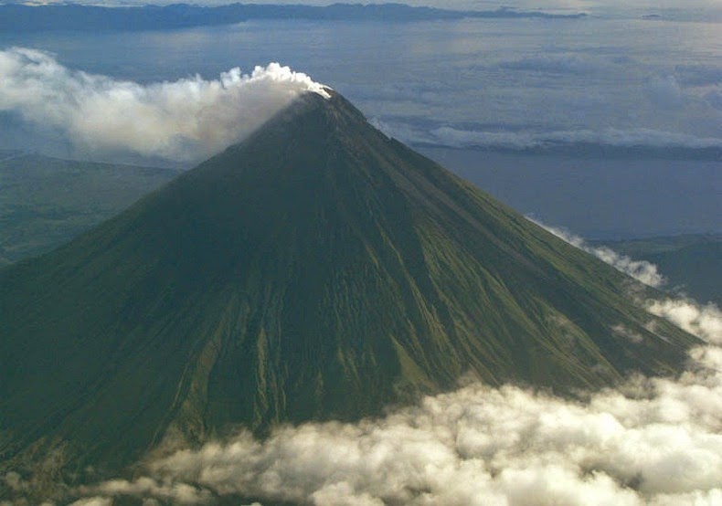
Mount Mayon, also known as the Mayon Volcano, is an active stratovolcano on the island of Luzon in the Philippines, renowned for its almost symmetric conical shape. Mayon is considered to have the world's most perfectly formed cone due to its symmetry, which was formed through layers of pyroclastic and lava flows from past eruptions and erosion.

The volcano is located on the convergent boundary where the Philippine Sea Plate is driven under the Philippine Mobile Belt. The lighter continental plate floats over top of the oceanic plate, forcing it down into the Earth's mantle, and allowing magma to well up from the Earth’s interior. The magma exits through weaknesses in the continental crust, one of which is Mount Mayon. In fact, Mayon is the most active volcano in the Philippines having erupted over 49 times in the past 400 years. Despite this, the volcano has managed to retain its perfect cone shape without suffering any major slides or collapse.


Mayon volcano is the main landmark of Albay Province rising 2462 meters above the Albay Gulf with very steep upper slopes averaging 35-40 degrees capped by a small summit crater. Because of its symmetric cone, the mountain was declared a national park and a protected landscape on July 20, 1938, the first in the country.

Another peculiarity is that Mayon volcano is geographically shared by the eight cities and municipalities which meet at the cone’s summit, dividing the cone like slices of a pie when viewed from above.


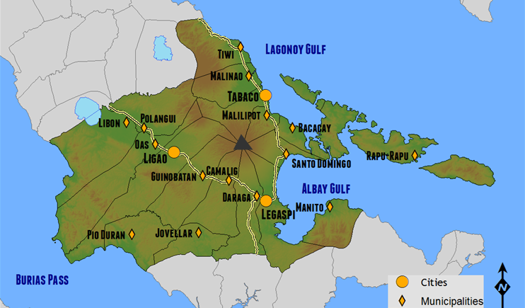
The location of Mayon in Albay province and the eight cities and municipalities that share the volcano


Source
READ MORE»

Mexican Venice

Mexcalitán is a small village on an island located in one of the lakes in the estuaries north of San Blas, in the municipality of Santiago Ixcuintla, in the Mexican state of Nayarit. The island is fascinating to look from the air. Two parallel streets cross the oval-shaped island from north to south, and two others from east to west, where they intersect in the middle to form a modern plaza. The only other street runs around the island in a circle, parallel to and not far from the water’s edge. There is church, a few shops, a billiards hall, a museum, and an administrative office at the central area of the village, while low houses, of adobe, brick and cement, line the dirt streets and extend right down to the water’s edge. For several months during the rainy season, the rising waters flood the streets making travel by boat the only option. For this reason, the island has earned the name “The Mexican Venice.”


This ancient island village is believed to be the ancestral homeland of the Aztecs before they set out on their pilgrimage in 1091 to found Tenochtitlan (modern Mexico City). These days Mexcaltitán is mostly a tourist town with shrimp fishing the main economic vocation of the island’s inhabitants. Men head out into the surrounding wetlands in the early evening in small boats, to return just before dawn with their catch. All day long, shrimps are spread out to dry on raised sidewalks. Aside from providing space for sun-drying of shrimps, these high curbs protect houses from flooding when water levels rise too high.


Source
READ MORE»

Manjanggul Lava Tube in Jeju Island

The volcanic island of Jeju, located 130 kilometers from the southern coast of the Korean Peninsula, has an extensive system of lava tubes. These natural conduits through which magma once flowed are now empty caves that are some of the largest in the world. These caves, apart from providing opportunities for scientific research, are popular tourist destinations.

The most impressive is the Geomunoreum Lava Tube System formed by the flow of basaltic lava when the Geomunoreum volcano erupted some 300 - 200 thousand years ago. The volcano has an elevation of 456 meters and lava flowed down to the coastline 13 km away, and while doing so, created numerous lava tubes. The Manjanggul Lava Tube represents the largest cave in this system. It stretches for 8,928 meters and its passages are up to 30 meters high and 23 meters wide.


The insides of the tube is adorned with multi-coloured carbonate decorations and innumerable cave formations commonly found in lava tubes. They include lava stalactites and lava stalagmites, lava columns, lava flowstone, lava helictites and lava blister, cave corals, benches, lava raft, lava bridges, lava shelves and striations. At the end of the one of the passageways open for tourists, is a massive lava column formed when a large amount of lava spilled from the upper level down to the lower level. This intimidating column stands 7.6 meters high and is the largest known in the world.

Some 30,000 common bent-wing bats (Miniopterus schreibersii) have taken permanent residence inside the tube, forming the largest colony of bats so far known to be living in Korea. About 38 types of cave creatures have been identified inside the Geomunoreum Lava Tube System, the most common of which is the Jeju cave spider (Nesticella quelpartensis).


Entrance to the cave.


The world's largest lava column in Manjanggul cave.


Source
READ MORE»

Bibi Ka Maqbara - The Second Taj Mahal

Do you know that India has not one but two Taj Mahals? Indeed, there is a monument identical to the Taj that stands in Aurangabad in Maharashtra. It is a mausoleum called Bibi Ka Maqbara ("Tomb of the Lady") built by Prince Azam Shah, the son of the sixth Mughal Emperor Aurangzeb, between 1651 and 1661 A.D, in the memory of his mother, Dilras Banu Begum.

Bibi Ka Maqbara draws its inspiration from the famous Taj Mahal of Agra built by none other that Prince Azam Shah’s grandfather, Mughal Emperor Shah Jahan in memory of his wife Mumtaz Mahal. Azam Shah intended to build a monument that would rival the Taj Mahal. Unfortunately, he lacked the treasury his grandfather had access to, as well as the skilled labour the treasury bought, resulting in a poor copy of the latter. Even so, Bibi Ka Maqbara is an architectural wonder with intricate designs, carved motifs, imposing structure and beautifully landscaped Mughal-style garden. Due to its strong resemblance to the Taj Mahal, it is lovingly called the “Taj of the Deccan”.


This is not Taj Mahal. It’s Bibi Ka Maqbara.

The mausoleum stands at the centre of a spacious enclosure measuring approximately 458 meters by 275 meters, with axial ponds, fountains, and water channels, many defined by stone screens and lined with broad pathways. The garden is enclosed by high crenelated walls with fortress set at intervals, and open pavilions on three sides. The mausoleum is built on a high square platform with four minarets at its corners, exactly like the Taj Mahal, and approached by a flight of steps from three sides. The main onion dome of the Maqbara is, however, smaller than the dome of the Taj and its minarets are shorter.

Seen by itself, Bibi Ka Maqbara is a beautiful piece of work, but it pales in comparison to its famous forbearer. While the monument in Agra is made entirely out of pure white marble, the mausoleum in Aurangabad is encased with marble only up to the dado level. Above this is covered with a fine plaster polished to give a marble-like finish. Only the onion dome was built with marble. The walls of the Maqbara are also a little dusky by contrast, which gives the mausoleum a duller appearance compared to the Taj. According to records, Bibi Ka Maqbara cost Alam Shah 700,000 Rupees to build. For comparison, the Taj Mahal was built at a cost of approximately 32 million Rupees at that time. This is probably another reason why Bibi Ka Maqbara is often referred to as the "poor man’s Taj".


Bibi Ka Maqbara’s diminutive status is a consequence of Aurangzeb’s lack of interest in architecture. Initially Aurangzeb was not in favour of building a monument as lavish as the Taj, and he prevented its construction by blocking the movement of marble from Rajasthan and various other parts of the Mughal empire. But his son Alam Shah was determined to have a monument to his mother that might vie with the Taj. Somehow, Alam Shah prevailed upon his father who eventually relented.

Legend has it that in 1803, Nizam Sikander Jahan was so captivated by the Maqbara that when Aurangabad and the Marathwada area were annexed to his kingdom he planned to shift the Maqbara to his capital, Hyderabad. He even ordered dismantling of the structure, slab by slab. But, somehow, he had a premonition of some disaster which might befall him were he to harm the existing structure. He stopped the work and as a penance got a mosque built, which still stands to the west of the main structure.


The tomb of Dilras Banu Begum.


Symmetrical designs and balconies line the octagonal tomb enclosure.


A view of the exquisite details on the marbled screen and ceiling inside the tomb enclosure.


View of the garden from Bibi Ka Maqbara.


Source
READ MORE»