Ancient Roman City With a Very Modern Grid Design

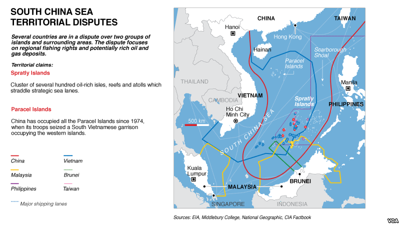
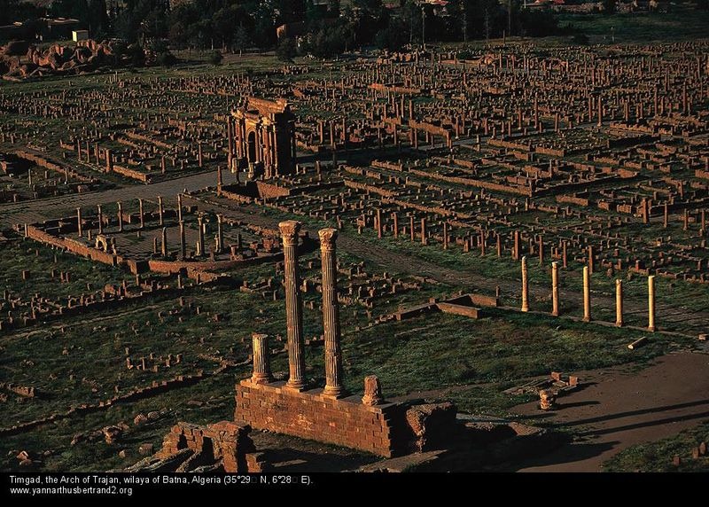
The ruins of Timgad lies on the slopes of the Aures Massif, about 35 km east of the town of Batna, in modern-day Algeria. Built nearly 2,000 years ago, by the Roman Emperor Trajan, the city is laid out in great precision and is one of the best surviving examples of the grid plan used by the ancient Roman city planners.

The city was originally founded as a military colony by the emperor Trajan around AD 100, intended to serve as a bastion against the Berbers in the nearby Aures Mountains. It’s original residents were largely Parthian veterans of the Roman army who were granted lands in return for years of service.


The city’s original design was a perfect square, 355 meters long on each side, with an orthogonal design highlighted by the decumanus maximus (east-west-oriented street) and the cardo (north–south-oriented street) lined by a partially restored Corinthian colonnade. The plan was to provide space for 15,000 residents, but the city quickly outgrew that number and spilled beyond the orthogonal grid in a more loosely but organized fashion. The city grew for the next 300 years as new quarters were added to the original ground plan leading to a quadrupling of the original size.

During its second and third century, the city enjoyed a peaceful existence. Perfectly located at the head of the Oued el-Abiod and a crucial junction, it gave Romans control of one of the main passes through the Aurès Mountains, and therefore of access to and from the Sahara. Starting from the 3rd century, it became a center of Christian activity, and a Donatist center in the 4th century. Timgad fell into decline after the Vandal invasion in the 5th century and the subsequent sacking by Berbers.

The city was revived in the 6th century under the Byzantine Emperor Justinian. A fortress was built outside the original town and many blocks from earlier Roman buildings were reused. But the city fell once again to an Arab invasion in the 7th century. The site was finally abandoned in the 8th century. The city was forgotten until it was excavated from under the sand in 1881.

All these centuries lying under the sand of the Sahara, Timgad remained exceptionally well preserved. At the west end of the decumanus maximus still stands a 12-meters-high triumphal arch, called the Arch of Trajan, which was partially restored in 1900. There a temple dedicated to Jupiter that is of approximately the same dimensions as the Pantheon in Rome. A large Byzantine citadel stands to the southeast of the city. There is also a 3,500-seat theater in good condition, a library, a basilica and four public bath houses.


Source
READ MORE»

Top 7 Highest Cities in the World

Like the microscopic bacteria, human beings too have learned to evolve and flourish in extreme conditions – from the scorching heat of the Sahara to the freezing tundra of Siberia. Even in inhospitable, high mountains where life supporting oxygen is low, humans have been living for millennia. Some 140 million people live permanently at high altitudes above 2,500 meters or 8,200 feet, in the Himalayas in Asia, the Andes in South America and in the Ethiopian Highlands of Africa, and some actually prosper in sprawling cities. Here we present 7 very high cities and settlements, each of which is located above 10,000 feet in elevation.
La Rinconada

La Rinconada in Peru is an old gold-mining camp in the remote Peruvian Andes, that has grown to ‘major city’ status. Over 50,000 people live in this mountainous city at an altitude of 16,732 feet (5,100 m). It lays claim to the title of “highest city in the world.”


Despite having an economy fueled almost entirely by the nearby gold mine, the town’s infrastructure remains poor. The city has no plumbing and no sanitation system, and there is significant contamination with mercury due to the mining practices.

Almost all the residents of this city are workers who emigrated to the remote location hoping to secure work and stake their claim in the riches. They work through a peculiar system of payment called Cachorreo. Employees work for 30 days without payment, and on the 31st day they are allowed to take as much ore from the mine as they can carry. Whatever the miners are able to extract from that ore is theirs. Despite the companies utilizing such a non-traditional system of payment, miners continue to flock to the region. The population of La Rinconada has skyrocketed over 230% in the last decade.


El Alto
The city of El Alto is one of Bolivia's largest and fastest-growing urban centers. With a population of over 1.1 million at an altitude of 13,615 feet (4150 meters), it is also one of the highest major cities in the world. At one time, El Alto was merely a suburb of the adjacent La Paz on the Altiplano highlands, but due to the migration from Bolivia's rural areas to the La Paz region during the 1950s, the region grew and in less than 40 years laid claim to “city status” of its own.

The region where El Alto stands is dry and inclement and was therefore uninhabited until 1903, when the newly built railways from Lake Titicaca and Arica reached the rim of the canyon, where the La Paz terminus, railyards and depots were built along with a settlement of railway workers. In 1925 the airfield was built as base for the new air force which attracted additional settlement. In 1939 El Alto's first elementary school opened. El Alto started to grow tremendously in the 1950s, when the settlement was connected to La Paz' water supply. Before that all water had to be transported from La Paz in tanker vehicles. 1985 the district of El Alto and surroundings was politically separated from the City of La Paz and in 1987 El Alto was formally incorporated as a city.


Potosi
Another candidate from Bolivia, Potosi, is located at an elevation of 13,420 ft (4,090 m). Founded in 1545 as a mining town, it soon produced fabulous wealth, becoming one of the largest cities in the Americas and the world, with a population exceeding 240,000 people. Potosi lies at the foot of the Cerro de Potosí - a mountain popularly conceived of as being made of silver ore, whose peak at 4,824 meters has always dominated the city. The Cerro Rico is the reason for Potosí's historical importance, since it was the major supply of silver for Spain during the period of the New World Spanish Empire.

It is from Potosí, that most of the silver shipped through the Spanish Main came. During 1556 to 1783, 45,000 short tons of pure silver were mined from Cerro Rico of which 9,000 short tons went to the Spanish monarchy. Due to such extensive mining, the mountain itself has diminished in height by a few hundred meters.

In 1672, a mint was established to coin silver and water reservoirs were built to fulfill the growing population's needs. At that time more than eighty-six churches were built and the city's population increased to nearly 200,000, making it one of the largest and wealthiest cities in the world. After 1800, the silver mines were depleted, making tin the main product. This eventually led to a slow economic decline. Nevertheless, the mountain continues to be mined for silver to this day. Due to poor worker conditions, lack of protective equipment and constant inhalation of dust, the miners still have a short life expectancy with most of them contracting silicosis and dying around 40 years of age.


Shigatse
Shigatse is the second largest city in the Tibet Autonomous Region (TAR) of the People's Republic of China. With a population of 100,000, it is one of the larger cities of Tibet. The city is located at an altitude of 12,600 ft (3,840 metres) at the confluence of the Yarlung Tsangpo (aka Brahmaputra) river and the Nyang River (Nyang Chu or Nyanchue) in west Tibet. Shigatse lies on flat terrain surrounded by high mountains, and the urban area is located just south of the Yarlung Zangbo River, located in the south-central Tibet Autonomous Region. The city was the ancient capital of Ü-Tsang province, and currently is the administrative centre of the modern Shigatse Prefecture, an administrative district of the TAR.


Juliaca
Juliaca is San Roman's capital city in the Puno Region, of southeastern Peru. It is the region's largest city with a population of 225,146 inhabitants (as of 2007) and located at 12,549 ft (3,825 metres) above sea level, on the Collao Plateau. It is the largest trade center in the Puno region. It is also a major transit point in the region and has strong ties with Peru's southern cities, including Arequipa, Puno, Tacna, Cuzco, Ilo, and with the Bolivian Republic.


Oruro
Founded on November 1, 1606 as a silver mining center in the Urus region, Oruro is now a major city in Bolivia with a population of 235,393 (2010 census), located at 12,159 ft (3,706 m) above sea level. After the silver mines exhausted, Oruro was reestablished in the late nineteenth century as a tin mining center. For a time, Oruro’s La Salvadora tin mine was the most important source of tin in the world. Gradually, this resource became less plentiful, and Oruro again went into a decline, although its primary employer is still the mining industry.


Lhasa
Located at the bottom of a small basin surrounded by the Himalaya Mountains, Lhasa has an elevation of about 11,800 ft (3,600 m) and lies in the center of the Tibetan Plateau with the surrounding mountains rising to 5,500 m (18,000 ft). The Kyi River (or Kyi Chu), a tributary of the Yarlung Zangbo River, runs through the southern part of the city. This river, known to local Tibetans as the "merry blue waves", flows through the snow-covered peaks and gullies of the Nyainqêntanglha mountains, extending 315 km (196 mi), and emptying into the Yarlung Zangbo River at Qüxü, forms an area of great scenic beauty.

Lhasa is the second most populous city on the Tibetan Plateau having a population of over 550,000. The city contains many culturally significant Tibetan Buddhist sites such as the Potala Palace, Jokhang temple and Norbulingka palaces, many of which are located in Chengguan District, the city seat.


A satellite image shows the mountainous terrain surrounding Lhasa. 


The famous Potala Palace.


Source:
READ MORE»

Progreso Pier - The Longest Pier in the World

The port city of Progreso, in the Mexican state of Yucatán, boasts of the longest pier in the world. Built with reinforced concrete, the pier juts out into the Gulf of Mexico for a distance of 6.5 km, and looks more like a bridge to some distant land. The unusually long length is necessary to allow large ships to dock since the Yucatan coast is very shallow. The limestone shelf that forms the Yucatán Peninsula falls away at such a shallow angle that it is literally kilometers before the water is deep enough to accommodate cargo vessels. Passengers disembark at the end of the long pier, and then take a free shuttle or a taxi cab to the shore and into town.

The pier was originally 2,100 meters long and was constructed between 1937 and 1941, replacing a wooden pier that was built in the beginning of the last century. In 1988, an additional 4,000 meters was added to its length increasing the pier’s cargo and container vessels handling capacity.


Photograph of the Progreso Pier taken from the International Space Station in 2014. 

The Progreso Pier is also the first concrete structure in the world built with nickel-containing stainless steel reinforcement. Despite the relatively poor grade of concrete used, the pier has withstood the harsh marine environment and has been in continuous service for over 70 years without any major repair or routine maintenance activities. On the contrary, a neighboring pier located just 200 meters to the west of the Progreso Pier is heavily deteriorated with columns and the superstructure almost entirely gone, despite being twenty years younger. The newer pier was built with carbon steel rebar.

Structural engineers often cite the example of Progreso Pier to show the consequences of using different materials during construction, and the importance of the choice of rebar material aside from concrete.


The Progreso Pier. The remains of the newer pier is seen in the lower part of this image. 


A cruise ship docks on Progreso Pier. 


The port of Progreso. 


Source
READ MORE»

A City That Includes Almost an Entire Ocean

On July 2012, China announced a new prefecture-level city called Sansha whose seat of administration lies on what it calls Yongxing Island, in the South China Sea, some 350 kilometers southeast of Hainan Island. The island, known on international charts as Woody Island, is so small that the 8,900 feet long (2,700 meter) airstrip, which the Chinese military completed in 1990, sticks out nearly half its length into the sea.

Sansha's government administers several island groups and undersea atolls, including the Spratly Islands, the Paracel Islands — of which Woody Island is the largest, the completely submerged Macclesfield Bank and a vast swath of the surrounding ocean. Sansha means "three sandbanks" in Mandarin and refers to these three groups of islands and atolls. The total land area of Sansha is less than 13 square km, but the water area claimed by the city approaches nearly 2-million square kilometers. This makes Sansha simultaneously the smallest and the largest city in China — smallest by land area and population, but largest by total area.


An aerial view of Woody Island, or Yongxing island.

The islands in the South China Sea are contested by several countries — Brunei, Malaysia, the Philippines, Vietnam, and Taiwan, over and above China. The Paracel Islands are claimed by Vietnam, but is now entirely controlled by China. The Spratly group is also claimed in entirety or parts by Vietnam, which occupies the largest number of islands, as well as by Malaysia, the Philippines, and Taiwan. The Macclesfield Bank, a vast, totally submerged atoll with rich fishing grounds to the east of the Paracels is also claimed by Vietnam, the Philippines, and Taiwan.

By establishing the city of Sansha in the disputed, resource-rich South China Sea, China is essentially asserting its right to the islands, and consequently its right to fish and drill in the vast oil reserves that is believed to be under the seabed. The area is also extremely significant in a geopolitical sense, being the second most used sea lane in the world. One-third of the world's shipping transit through its waters.

Since the announcement of Sansha, development on Wood Island has been undergoing at a swift pace, even as Vietnam and the Philippines continue to voice their protest. The Philippines said it does not recognize the city or its jurisdiction, and Vietnam said China's actions violated international law. The US government also voice its concern by stating, "we remain concerned should there be any unilateral moves of this kind that would seem to prejudge an issue."

Living facilities on Woody Island have been built along with official buildings, banks, libraries, an observatory, hotels, hospitals and other important buildings. The city has also recently started taking on tourists, and for that purpose built two museums. Other tourist attractions include a couple of monuments and towers left by the Imperial Japanese Army during WWII.


An aerial view of Woody Island, or Yongxing island. 


Located five miles Southwest of Yongxing Island, Qilianyu consists of seven small islands, and is part of Sansha. 


An aerial view of the Islets and reefs in the Yongle archipelago in Sansha. 


An aerial view of the village on the Yagong Islet in Yongle archipelago in Sansha. 


Fishing boats and public service vessels rest along Woody Island harbor. 


The government building of Sansha was built on Woody Island. 


The view of Woody Island from a nearby jetty. 


A sign at Woody Island, which is the center of government for Sansha. 

 
An aerial view of a port located at the southern part of Woody Island


Source
READ MORE»