The Honghe Hani Rice Terraces

The Honghe Hani Rice Terraces in Southern Yunnan, China, covers an immense 16,603-hectares. These spectacular terraces cascade down the slopes of the towering Ailao Mountains to the banks of the Hong River. The terraces rise by 3,000 steps at varying angles from a shallow 15 degrees to a steep 75 degrees, forming a magnificent landscape that is rare both at home and abroad. Over the past 1,300 years, the Hani people have developed a complex system of channels to bring water from the forested mountaintops to these terraces. They have also created an integrated farming system that involves buffalos, cattle, ducks, fish and eel and supports the production of red rice, the area’s primary crop.

The Hani people first came to the steep mountains some 2,500 years ago. They struggled against the difficult terrain, successfully establishing the terraces, where they grew rice in order to make a living. The technology of developing fertile land on rugged mountain slopes didn't spread all over China and Southeast Asia until 14th century. In recognition of the Hani people’s creativity, the Ming Dynasty emperor granted them the title of 'Skillful Sculptor' and their good reputation was passed down from generation to generation. Last week, the terraced fields were officially acknowledged by UNESCO as a World Cultural and Natural Heritage site.


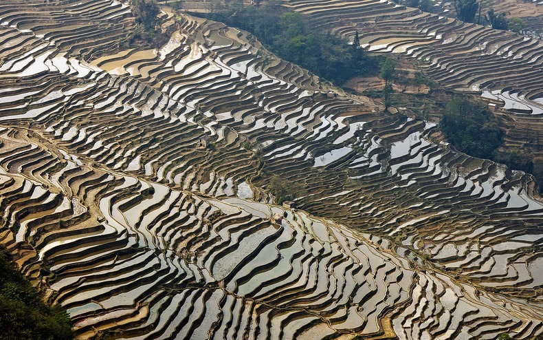
Although not exactly a tourist destination, hordes of photographers have visited Yuanyang Rice Terraces. The landscape changes vividly through the year. In April the terraces are all green as rice started to grow, in later parts of the year it is yellowish brown as the rice ripens. In February, the terraces become naked bare earth, with the water reflecting the sky.

"The Honghe Hani terraces are an outstanding reflection of elaborate and finely tuned agricultural, forestry and water-distribution systems that are reinforced by long-standing and distinctive socioeconomic-religious systems," said the council in the announcement last Saturday..

"Its terraced landscape reflects, in an exceptional way, a specific interaction with the environment mediated by integrated farming and water-management systems, and underpinned by socioeconomic-religious systems that express the dual relationship between people and gods, and between individuals and community, a system that has persisted for at least a millennium, as can be shown by extensive archival sources."

The Honghe Hani Rice Terraces marks China's 45th World Heritage and 31st World Cultural Heritage, making China the second country with the most nominations, after Italy.


Source
READ MORE»

Cerro Sarisarinama Sinkholes

Cerro Sarisarinama is a table-topped mountain called a tepui, in Jaua-Sarisariñama National Park at the far south-west of Bolívar State, in Venezuela, near the border with Brazil. The name of the mountain originates from a legend of the indigenous Ye'kuana Indians that speaks of an evil spirit living in caves up in the mountain. Sometimes the evil spirit is heard devouring human flesh and then a terrible sound "Sari... sari..." is heard.

The tepui is located in one of the most remote areas in the country, with the closest road being hundreds of miles away. Unlike other tepuis, Cerro Sarisariñama is heavily wooded with 15–25 metre-high forest fully covering the top of it. This isolated ecosystem is home to numerous endemic species of plants and animals.


The most distinctive features of Cerro Sarisariñama are its gigantic sinkholes – four in total, with the largest one, called Sima Humboldt, is up to 352 metres wide and 314 metres deep. Down below Sima Humboldt expands to 502 meters wide. The other well known sinkhole Sima Martel is equally impressive at 248 meters deep. Both sinkholes are roughly circular and are located just 700 meters away from each other. The view of these gigantic holes from up the air is quite stunning.

The sinkholes were first discovered in 1961 by pilot Harry Gibson, but the first expedition could only be organized in 1974. The team, consisting of numerous explorers and specialists, descended into the sinkhole with ropes only to realize that getting out was not easy. The sinkhole widens as it goes down making the ropes hang freely. After several days the men made a desperate attempt to cut giant trees to make an open space for the helicopter to land. Eventually they used cable ladders to get out, but who knows how many rare species of plants were unnecessarily destroyed.

The second expedition team arrived two years later and they came more prepared than the first. This team discovered the third sinkhole - Sima de la Lluvia, which was a quartzite cave. For some two decades Sima de la Lluvia remained the longest known quartzite cave (1.35 km) in the world.


Source
READ MORE»

The Sunken Sin City at Port Royal

Port Royal was a city situated on the end of an 18-mile long sand spit known as the Palisadoes, at the mouth of the Kingston Harbour, in south-eastern Jamaica. Founded in 1518, it rapidly grew to become the most important trading post in the Caribbean Sea due to its strategic position on the trading routes between the New World and Spain. When England officially appointed privateers to raid enemy ships in the Caribbean, as a part of its defence strategy, pirates from around the world congregated at Port Royal to legitimize their trade. Soon Port Royal became a notorious hub for pirate activity, gambling, prostitutes, and booze leading it to be branded as "the wickedest city on earth".

Port Royal’s glory days didn’t last long. At the height of its glittering wealth on June 7, 1692, a massive earthquake shook Jamaica. The sea swallowed the town killing 2,000 people and wounding 3,000 others. The local clergy ascribed the destruction of Port Royal as God's punishment on the people for their sinful ways. Today, the area is a shadow of its former self with a population of less than 2,000 and little to no commercial or political importance.


The first Europeans to land on Jamaica were the Spaniards under the leadership of Christopher Columbus in 1494. Spain maintained control over the island for 146 years, until the English invasion of 1655. As a solution to their defence concerns, the then Governor of England invited pirates to Port Royal giving them official “letters of marque” to go after Spanish ships and settlements. The strategy proved to be so successful that Spain was forced to continually defend their property. With ships frequently looted, it struggled to provide its colonies with manufactured goods on a regular basis.

Port Royal meanwhile flourished. Between 1655 and 1692, it grew faster than any town founded by the English in the New World. At its height in 1692, the town had a population of 6,500 and 2,000 buildings densely packed into 51 acres. Its free-spending inhabitants threw away their money in gambling, whoring and drinking, and the town developed a reputation as a den of wickedness and godlessness.

When Charles Leslie wrote of Port Royal in the 1660s, he included the description: “Wine and women drained their wealth to such a degree that... some of them became reduced to beggary. They have been known to spend 2 or 3,000 pieces of eight in one night; and one gave a strumpet 500 to see her naked. They used to buy a pipe of wine, place it in the street, and oblige everyone that passed to drink.”


A painting representing the 1692 earthquake that destroyed the city partially sunken it into the seas.

Port Royal’s extravagance came to an abrupt end on June 7, 1692 when a massive earthquake and tsunami struck causing two-thirds of the town to fall into the sea. A series of fires and hurricanes followed and the town was never restored to its former glory. Port Royal lived out its days as a British naval station and today remains as a small fishing village. However, the part of the town lying at the bottom of the shallow sea is considered the most important underwater archaeological site in the western hemisphere, yielding many 16th–and-17th-century artefacts. From UNESCO’s website:


Many of the materials found in the underwater city of Port Royal, are perfect expressions of authenticity, found just exactly as they were originally being used or where they were stored. Cast-iron skillets and pots were still in the hearth with charred wood from the fire concreted to their surfaces. Stacks of pewter plates were found as they fell from their storage space under the stairs in what is surmised to be the serving area of one building. The remains of children were found among the broken walls of their home. Also, uncovered were the remains of barrels containing the trash of the day, including the trimmings of a man's beard and hair in a yard area. Many ceramics were found intact or broken where they fell.

Many of the items recovered over the years from the bottom can be seen at the Museums of History and Ethnography at the Institute of Jamaica in Kingston.


CGI artwork depicting how Port Royal may have looked like.


CGI artwork depicting how Port Royal may have looked like.


CGI artwork depicting how Port Royal may have looked like.

 
CGI artwork depicting how Port Royal may have looked like


Source:
READ MORE»

Hidden Beach Formed by Military Bombing

Marieta Islands are a group of small uninhabited islands a few miles off the coast of Nayarit, in Mexico. Ever since the islands was labelled a national park, there has been an increase in marine life populations due to the islands being protected from fishing and hunting by the Mexican government. Over the last few years Marieta Islands have turned into a popular tourist destination drawn by the rich fauna that include creatures like humpback whales, dolphins and manta rays. Among the many natural wonders on the islands, one is a “Playa del Amor” or “the beach of love” but commonly referred to as the “hidden beach”. The beach is so called because it’s entirely hidden in a sinkhole-like cave, and can only be reached by swimming through a short, narrow tunnel. While the beach itself is natural, the sinkhole under which the beach lies is reportedly man-made.


The Marietas Islands were originally formed many thousands of years ago by volcanic activity. Being completely uninhabited, the Mexican government started using the islands as target practice prior to the First World War. These controlled bombings have formed numerous caves and other unique rock formations on the Marietas Islands. It is believed that the Hidden Beach was created as a result of these bombings together with natural erosion of the rocks surrounding it.

After a massive international outcry, started by scientist Jacques Cousteau in the late 1960s, the government eventually decided to label the islands a national park. Today the islands are protected from human activity and only a few tour operators are allowed to take tourists there after obtaining necessary permits.


Source
READ MORE»

The Lonely Castle of Mada'in Shaleh

Mada'in Saleh is an ancient city of pre-Islamic period located in northern Saudi Arabia, about 1,400 km to the north of capital Riyadh. It lies in a strategic position on one of the most important ancient trade routes, which linked the south of the Arabian peninsula to the north, as well as to the great economic and cultural centres of Mesopotamia, Syria and Egypt. It is considered one of the most important and oldest ancient cities in the country and the second largest city of the Nabateans who rules in the first century AD. Today, Mada'in Saleh is an archeologically important site with majestic ruins that are often compared with those of Petra. The most stunning among these ruins and the most iconic symbol of Mada’in Saleh is Qasr al-Farid, rising four stories tall not far from the center of the ancient Nabataean city of Hegra.


“Qasr al-Farid” means “the lonely castle”, so called because it stands completely isolated from the others. But despite its fanciful name, Qasr al-Farid is only a tomb. It was carved out of a single rock sometime in the first century A.D., but its facade was never finished which makes the tomb an interesting study. The heavily chiselled surface of the lower third documents how these tombs were fashioned from the top down. Qasr al-Farid is just one of ninety-odd such monumental tombs carved here during the heyday of the Nabataeans.


Source
READ MORE»