The Highest Unclimbed Mountain in the World

Gangkhar Puensum is the highest mountain in Bhutan, and at 7,570 meters, it is the 40th highest peak in the world. As surprising as it may sound, Gangkhar Puensum still remains unclimbed, especially when most peaks in the Himalaya have already been scaled decades ago.

Gangkhar Puensum lies on the border of Bhutan and Tibet, although the exact boundary line is disputed. Chinese maps put the peak squarely on the border whereas other sources put it wholly in Bhutan. When the mountain was first mapped and surveyed in 1922, maps of the region were shockingly inaccurate. Until very recently, maps of the region showed the mountain at different locations and marked with different heights. In fact, one of the first team to attempt the summit was unable to find the mountain at all.


Bhutan opened itself up to mountaineering only in 1983, as they believed that towering mountains were the dwelling of spirits. When Bhutan finally opened its doors to mountaineering, a series of expeditions were organized. Between 1985 and 1986, four attempts were made, but all ended in failure. The decision to allow mountaineering as a commercial pursuit didn’t last long. In 1994, the government forbade climbing of mountains higher than 6,000 metres out of respect for local spiritual beliefs, and since 2004 mountaineering in the country has been banned completely.

In 1998, a Japanese expedition acquired permission from the Chinese Mountaineering Association to climb Gangkhar Puensum north of Bhutan from the Tibetan side. But a longstanding border dispute with Bhutan, finally caused the permit to be revoked. Instead, the expedition settled for a previously unclimbed 7,535-meter subsidiary peak of Gangkhar Puensum called Gangkhar Puensum North, also known as Liankang Kangri. Notes taken by the team suggested that the expedition to the main summit would have been successful if allowed. Curiously, unlike other maps the expedition's report shows Gangkhar Puensum as being in Tibet, rather than Bhutan, and the Tibet–Bhutan border is shown crossing the summit.

Bhutan itself has not surveyed the peak yet, and it appears that the country has no interest in doing it any time soon. With the difficulty of securing permits from the government as well as lack of rescue support, it seems that the mountain will likely remain unclimbed for the foreseeable future.


The location of Gangkhar Puensum shown by the marker “A” on the Bhutan-Tibet border.


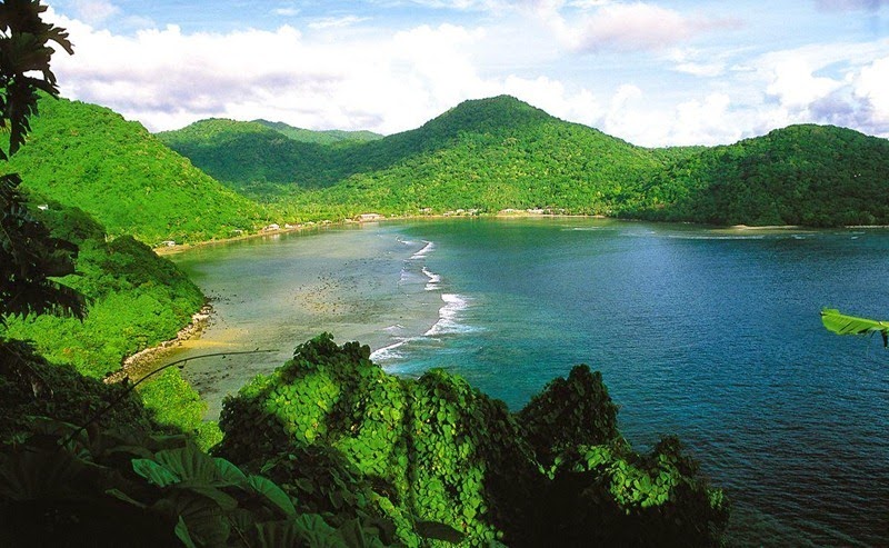
Gangkhar Puensum from Ura valley, Bhutan.


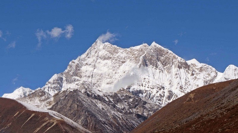
The approach to Gangkhar Puensum.


Source
READ MORE»

The Island Where Everyone is Related

Palmerston Island is a coral atoll in the Cook Islands in one of the most isolated part of the Pacific Ocean, about 3,200 km from New Zealand. The tiny Pacific island has no airport, and is visited by a supply ship only twice a year. The journey to the island is so long and hazardous that only the most intrepid visitors ever dares to visit it. But Palmerston’s fame comes not only from the fact it is a perfect island paradise, but from its unique history.

Palmerston Atoll is made up of a number of sandy islets on a continuous ring of coral reef enclosing a lagoon. Six of them are of significant size including Palmerston, North Island, Lee To Us, Leicester, Primrose, Toms, and Cooks, that together cover just 1 square mile (2.6 km2) in area. The atoll is 11 km across and 15 km from north to south that encloses an area of 56 square kilometers of sea.


The first person to set foot on Palmerston was Captain Cook in 1777, although he had discovered the island three years earlier on another trip. Cook named the island after Henry Temple, 2nd Viscount Palmerston, then Lord of the Admiralty. The island remained largely uninhabited for almost another century when it was chanced upon by William Marsters, a carpenter and barrel maker of a whaling ship that frequented the Bay of Islands, in 1860. William Marsters was so charmed by the island that three years later he returned with a wife, the daughter of the chief of another Cook island, and her two cousins with the intention of permanently settlement on the island.

The atoll was uninhabited at the time, and Marsters used wood salvaged from shipwrecks to build and populate a tiny community, which soon included a church, school room and homes. Marsters, together with the three women, had 17 children whose descendants make up the present population of Palmerston. Today, Palmerston has 62 inhabitants, all but three are descended from William Marsters.

Before he died William Marsters, organized the island so that each of the three wives and their descendants had a share of the main island and each of the atolls. This arrangement still stands. Today the Island has its own Council, representing the local government, and members of the three family. Marriage within a family group is prohibited.

Palmerston Islanders still pride themselves on their British heritage – they fly the British flag on special occasions, have large photos of the Queen in their homes, and remember fondly the visits of the Royal Yacht Britannia. Although it is administered by the Cook Islands government under the jurisdiction of New Zealand, in 1954 the family was granted full ownership of the island.

Life on Palmerston is simple. There are no shop, just two toilets, and rainwater is collected for drinking water. Money is only used to buy supplies from the outside world not from each other. Electricity runs from 6am – 12pm each day and again at night. A recently built telephone station provides the only permanent link to the outside world. Fish is the islanders' staple food and their only export. One or two tons of parrot fish are frozen and collected by the supply ship which comes twice a year to deliver essential supplies such as rice and fuel.

Aside from the cargo ships, the island sees about a dozen visiting boats a year bringing tourists. Since there are no resorts or hotels, by custom, the family that first greets the visitors offer them a homestay at their house.


Islanders: William Marsters and his brood.


Willima Marsters’ gravestone.


Satellite telephone and solar panels.


Source
READ MORE»

The Valley of 10.000 Smokes

On June 6, 1912, after five days of violent earthquakes on the Alaska Peninsula, one of the most gigantic eruptions of the 20th century occurred from a previously unknown geological formation called Novarupta, Latin for “new eruption”. For 60 hours the eruption sent ash and pumice into the sky as high as 30 km and darkened the sky over most of the Northern Hemisphere. As the ejected materials rained down back into the valley it smothered a 100-square km area with ash and pyroclastic flows up to 200 meters deep. Ash fell two feet deep in the neighbouring Kodiak Island 185 km away, and fumes produced acid rains 600 km away, tarnishing brass as far away as California and Colorado. The high-altitude haze robbed the northern temperate zone of an estimated 10 percent of the Sun’s heat during the summer of 1912.

Four years later when National Geographic Society sent Robert F. Griggs for a cover story, he found the valley engulfed in superheated steam escaping from thousands of fissures and cracks. The incredible sight prompted him to name the once vibrant valley “the Valley of Ten Thousand Smokes.”


Now a hundred years later, most of the fumaroles are extinct and the valley is no longer filled with smoke, but signs of volcanic activity are still visible on nearby hills. The region has been so scarred that in the 1960s it was used in training U.S. astronauts for moon landings. Novarupta itself is a mere bump on the Valley’s floor and rises only 65 meters above its surface. When explorers first entered the Valley, this was one of the hottest areas and the dome still wafts warm steam.

During the eruption a large amount of magma was drained from magma chambers below resulting in the collapse of the summit of another volcano - Mount Katmai, about 10 km away from Novarupta. The collapse produced a crater about two miles in diameter and over 800 feet deep. Early investigators assumed that Katmai was responsible for the eruption. It was not until the 1950s that true source of the eruption was discovered.

Today you can take the trip from Brooks Camp out to the Valley of Ten Thousand Smokes, where the turbulent Ukak River and its tributaries have cut deep gorges in the accumulated ash. The region is still recovering and plants have began to grow on the valley floor. The valley is not yet able to unable to sustain animal life, but moose and bear may cross it from time to time.


Griggs fry bacon over a hot opening of the Valley of Ten Thousand Smokes, 1916


The lava dome of Novarupta today.


Katmai National Park and Preserve, Alaska. Cross section of the June 1912 ash flow exposed by the River Lethe in the Valley of Ten Thousand Smokes.


 Source
READ MORE»

Kiribati - The Land of The Rising Sun

When the sun sets on the evening of December 31 this year, and the world awaits the arrival of the new year, a tiny island country on the extreme east will already have begun celebrations. Located just to the west of the International Date Line, the Republic of Kiribati is one of the first places on earth to see the first rays of the rising sun. Their time zone is 14 hours ahead of UTC - the farthest forward time zone in the world.

The Republic of Kiribati consist of 33 atolls and low coral islands in the central Pacific Ocean dispersed over 3.5 million square kilometres of water. The nation comprises of three island groups - Gilbert Islands, Phoenix Islands, and Line Islands, the last of which are located as far as 30° east of the 180° longitude line. Geographically, Line Islands lie directly to the south of the U.S. islands of Hawaii, and should logically be in the same time zone. But this is not the case, because the International Date Line is not a straight line but zigzags around quite a bit and over the years has been shoved and shifted for various political and economic reasons.


The Island of Kirimati, part of the Republic of Kiribati, is one of the few inhabited islands to experience the arrival of the new year before anybody else.

Take Kiribati itself, for example. Prior to 1995, Kiribati straddled the International Date Line with the eastern and western islands groups having a time difference of 24 hours. This was viewed as an annoying economic nuisance, as there were only four days in each week when both sides experienced weekdays simultaneously, and these were the only days when government offices on opposite sides of the line could conduct business. To put an end to this situation, the president of Kiribati at that time announced that on 1 January 1995 the International Date Line would henceforth move eastwards to go around this country. In doing so, Kiribati became the first nation to greet the rays of the rising sun at the begin of the third millennium. To celebrate the occasion, they even renamed Caroline Island to Millennium Island in the year 2000.

The bending of the International Date Line also created a new time zone UTC+14 that didn’t exist until then. The new development meant that some places were pushed as far as 26 hours behind, or more than a day.


The crooked International Date Line. See how it goes out of the way to wrap around Line Islands.

Taking a cue from Kiribati, another island territory – Tonga, advanced their standard times to UTC+14 and therefore celebrates new year at the same time as the Line Islands in Kiribati. Changes to the date line occurred as recently as 29 December 2011 when yet another island – Samoa moved the international date line to the other side of the country and advanced the country from UTC−11 to UTC+13. Following Samoa’s decision, Tokelau also advanced its standard time from UTC−11 to UTC+13.

Although a nation is authorized to modify their respective time zones, many countries and organizations do not recognize the change. The International Date Line is established by international agreement and there are no treaties or formal agreements associated with the line. Countries are free to choose whatever time zone they wish to observe. This has caused many date line disputes among a handful of island nations each claiming to be the first to celebrate a new year. Then there is the question of whether uninhabited islands count, or whether or not locations within the same time zone but slightly more eastern than the others actually can claim to celebrate the holiday first.

According to the current accepted time zones, the first place to welcome the new year is Kiribati, followed by Tonga. Western Samoa, and Tokelau, follows an hour late. The New Zealand territory of Chatham Islands and the Republic of Fiji follow close behind. The first major city is Auckland, New Zealand, and the last place to celebrate the arrival of the new year is the uninhabited Baker Island and Howland Island, both belonging to the United States.

Correction: Fiji and New Zealand, including the Chatham Islands, has Daylight Saving Time during the Southern Hemisphere Summer, which is around New Year. During this time their time zone advances to UTC+13, except for the Chatham Islands which goes even further to UTC+13.75. This makes New Zealand among the first places in the world to celebrate the New Year - just behind Kiribati's Line Islands. (Thanks Ross).


Satellite photo of Caroline Island, whose name was changed to Millennium Island in 2000 to celebrate the new millennium.


Satellite picture of Atafu Atoll, an inhabited island belonging to Tokelau, that lies in the time zone UTC+13.


American Samoa, the last place on earth to see the new year.


Source
READ MORE»