The Witch's Well in Tuhala Estonia

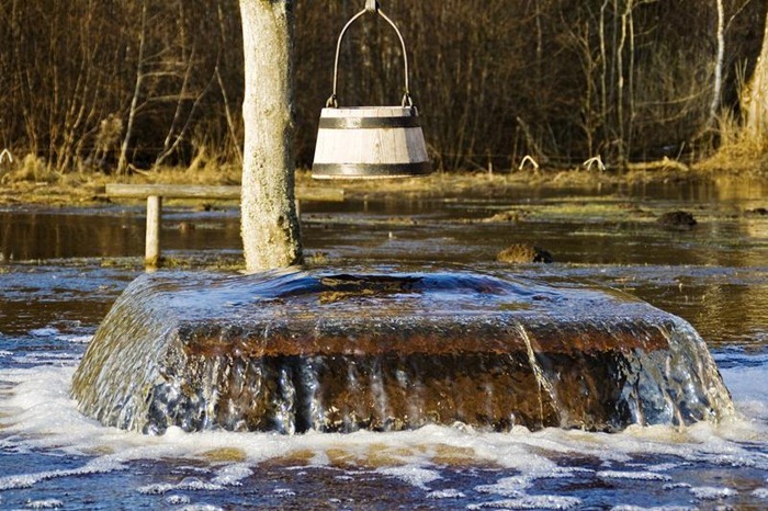
The Witch’s Well, as it is called, is a peculiar attraction in the Estonian village of Tuhala. The well for the most time appears normal. But after a heavy downpour, it begins to spout water and floods the entire area – an occurrence the local people attributes to the misdoings of witches. According to legend, the witches of Tuhala gather in the sauna underground and beats each other vigorously with birch branches, oblivious to the commotion they create on the surface.


The truth is, the well happens to be placed just over an underground river. After rain water floods the river, water pressure builds to the point that it shoots up out of the well, usually for a few days. The well is only 2.5 m deep, but under pressure it can spurt water up to half a meter. It is said that more than 100 liters of water can flow out every second.

The well doesn’t “boil over” after every heavy rain. The last time it did was in April 2010, and before that in 2008 after a period a three years. And when it does, tourist all over Estonia come to witness it.


The Tuhala’s Witch well when it’s not flowing


Source
READ MORE»

Devil's Kettle

The Devil's Kettle is a puzzling geological phenomenon located inside Judge C. R. Magney State Park in Minnesota, in USA, just off the North Shore of Lake Superior. As the Brule River makes it way through the park, it drops 800 feet in elevation and creates numerous waterfalls in the process. One of these waterfalls is quite special. About 2.4 km before the river empties into Lake Superior, it gets split in two by a rocky outcrop. The eastern part drops 50 feet below and continues towards Lake Superior. The western part falls 10 feet into a giant pothole - the Devil's Kettle - and disappears. Nobody knows where the water goes. It is believed there must be an exit point somewhere beneath Lake Superior, but it has never been located. Over the years, researchers have dropped brightly colored dyes, ping pong balls, and other objects into the Devil's Kettle. So far, none has ever been found.


One theory is that the river flows along an underground fault and comes out somewhere under Lake Superior. This is unlikely, because for this to happen, the fault would have to be precisely oriented towards the lake, and would have to be large enough to allow the flow of half the river. Even if such a fault exist, it would have likely been clogged over the years as rocks, sand, logs and other materials fell into the kettle. Besides, there is no evidence of such a fault in the area.

Another theory is millions of years ago a lava tube formed when the rocks first solidified. The problem with this theory is that the rock at Devil’s Kettle waterfalls is rhyolite, and lava tubes never form in rhyolite. Lava tubes form in basalt flowing down the slopes of volcanoes, and the nearest basalt layer to Devil’s Kettle is located much too far underground to be any kind of factor in the mystery. The existence of a large underground cave is also ruled out because underground caves form in limestone rock, and there are no limestone in the area.

The mystery is compounded by the fact no floating debris suddenly appearing at one spot offshore in Lake Superior has ever been reported.


Source
READ MORE»

The Dissapearing African Mountains Glaciers

Africa is typically isn’t the place that inspires visions of ice and glaciers, yet surprisingly, there are a number of glaciers in Africa, and they are all located near the equator. If you recollect your high school science lessons, you’ll remember that climate depends not only on latitude but also altitude of the place, and Africa is home to some majestic mountains, three of which proudly boast glaciers. They are Mount Kilimanjaro in Tanzania, Mount Kenya in Kenya, and the Rwenzori Mountains bordering Uganda and the Democratic Republic of Congo. But these glaciers are rapidly disappearing. Since 1900, the glaciers in Africa has lost 80% of their surface area. By the 1990s, they had a total surface area of only 10.7 square km. Scientists predict that by 2030, the last remaining ice would be melted away.


Rwenzori mountain.

Mount Kilimanjaro is 5,895 meters high and is located in northern Tanzania, 300 km south of the equator. It is the highest mountain in Africa and the world’s highest free-standing mountain. The white cap of Kilimanjaro varies in size over the year, and may grow and shrink depending on solar radiation, precipitation and other factors. But since the 1900s, there is clear evidence that the glaciers have shrunk consistently and dramatically. An estimated 82% of the icecap that crowned the mountain when it was first thoroughly surveyed in 1912 is now gone, and the ice is thinning as well. At some places the ice is just one meter thick. According to some projections, if recession continues at the present rate, the majority of the glaciers on Kilimanjaro could vanish in the next 15 years.

Likewise, the glaciers on Mount Kenya, Africa’s second highest mountain, and those on Rwenzori is retreating as well. Rwenzori has been dubbed the "African Alps," and the "Mountains of the Moon", and its glaciers are the highest water source for the Nile River. Its disappearance threatens dozens of plant and animal species that call the range home.

The disappearing glaciers provide compelling demonstration of the effects climate change. Gradual increase in air temperature and lack of rainfall is believed to be the major cause. It is unsure just how much longer the glaciers will be around to see.


Glaciers on Margherita Peak on Rwenzori mountains.


Wings of Kilimanjaro.


A glacier on Mt. Kilimanjaro, Tanzania.


Margherita Glacier on Rwenzori mountain


A glacier on Mt. Kilimanjaro, Tanzania.


Source
READ MORE»

Dinosaur Stampede in Lark Quarry

About 95 million years ago, a herd of two-legged dinosaurs, some as small as chickens and some about the size of emus came to drink at the muddy shore of a lake, located at what is now Lark Quarry, about 110 km southwest of Winton, in central-west Queensland, in Australia. Something caused them to panic, perhaps the presence of a large predator, and the herd swiftly swam across the lake. In doing so they left footprints on the soft mud which later got buried beneath sand and silt as the lake and river levels continued to rise and fall. Over thousands of millennia, the sandy bed, swamps and lush lowland forest dried up, and the sediment covering the footprints was compressed into solid rock.

Fifty years ago, a local station manager discovered the fossilized footprints while looking for opals. At first he thought they were fossilized bird tracks, but it wasn't until scientists visited the area in 1971 that the footprints began to reveal their true story. Today the footprints, referred to as the “dinosaur stampede” is preserved inside a building at Lark Quarry Conservation Park.


The site has about 3,300 separate footprints that seems to have been made by about 150 dinosaurs belonging to two different species - carnivorous coelurosaurs about the size of chickens, and slightly larger plant-eating ornithopods, some of them as large as emus. The area measures about 22 meters by 22 meters in size.

The herds of Coelurosaur and Ornithopod may have come down to a stream or lake to drink, when a large predator – a Theropod, appeared from the north causing the herd to flee across the lake. Later research however, challenge this story. Analysis of the sediments indicate that the area had no prehistoric lake. Instead, the deposits were made by an ancient channel of water flowing at different depths and speeds at different times. The researchers also didn’t find evidence of a coordinated run in one direction. Rather, the footprints were made over a period of time, perhaps several days, as dinosaurs crossed the channel at different times and under varying conditions. Based on track size and presumed skeletal proportions, the researchers estimated that the dinosaurs stood between five inches and five feet at the hips. And contrary to previous interpretations, only one species of dinosaur was responsible for the abundance of tracks.

We may never really know exactly what happened at Lark Quarry millions of years ago, but the site still represents one of the highest concentrations of dinosaur tracks in the world.


Source
READ MORE»

The Glittering Interior of Shah e Cheragh

Shah-e-Cheragh is a funerary monument and mosque located in the city of Shiraz, in Iran, where lies the tomb of Amir Ahmad and his brother Mir Muhammad, sons of the seventh Imam and brothers of Imam Reza. Amir Ahmad and Mir Muhammad were hunted down and killed by the caliphate on this site in AD 835 during the Abbasid persecution of the Shi'ite sect. The brothers' tombs, originally only simple mausoleums, became celebrated pilgrimage destinations in the 14th century when the pious and art-loving Queen Tashi Khatun erected a mosque and theological school by the tombs. After carrying out essential repairs, the queen ordered the tomb to be covered with millions of pieces of colored glass that glitter in the light and magnify its brilliance a thousand times. Shah-e-Cheragh is one of the most beautiful mosques and an important pilgrimage center of the city of Shiraz.


The wide mosque is flanked by two minarets and dominated by a dome is located in the west wing. The high eaves are supported by thick octagonal columns connected by a wall of green marble, carved entirely of wood. The entrance is guarded by a heavy door, plated with gold and enamel with a glass panel at its center. The pilgrims kiss and fondle the door as you enter.

Inside, the enormous dome above the shrine is inlaid with hundreds of thousands of pieces of finely crafted tiles, and the interior walls are covered with myriad pieces of dazzling glass intermixed with multi-colored tiles – green, yellow, red and blue, interspersed with glasses of paler shades sometimes. High and large windows down to the ground are largely made up of mosaics of stained glass which are reflected in the mosaics of mirrors. Embedded in the walls everywhere are verses from the Quran written on silk paper and framed. The green marble floor is covered with thick red Iranian carpets and magnificent crystal chandeliers hang from the ceiling above.


In the center, under the dome, lies the tomb of Syed Mir Ahmad. The marble tombstone, topped with a wide, low lacquer box inlaid structure is surrounded by a finely engraved silver with glass openings showing the inside. Verses from the Quran are written in gold letters on a blue background, and flowers are inlaid or carved into the metal. In another corner lies the tomb of Mir Muhammad that looks the same but much smaller than the tomb of his elder brother.

The brothers’ tombs were built in the 12th century by the chief minister to the monarch Atabeg Abū Sa'id Zangi, who also built the tomb chamber, the dome, as well as a colonnaded porch. The mosque remained this way for roughly 200 years before further work was initiated by Queen Tash Khātūn during the years 1344-1349 AD. She carried out essential repairs, constructed an edifice, a hall of audience, a fine college, and a tomb for herself on the south side. She also presented a unique Qur'an of thirty volumes, written in golden Sols characters with gold decoration, which is now preserved in the Pars Museum.


Source
READ MORE»