Tufa Towers of Mono Lake, California

Mono Lake is a shallow salt water lake located in the high desert on the eastern slope of the Sierra Nevada Mountains, in California in the United States. The lake has no outlet to the ocean causing high levels of salts to accumulate in the waters. As a consequence of its high salinity, no fish live in Mono Lake, but there are plenty of brine shrimp that thrive in its waters. Over two million annual migratory birds use Mono Lake as a stop over and resting place as they fly to South America or the tropical oceans. They feed on the shrimps, lay eggs and hatch their young ones here.

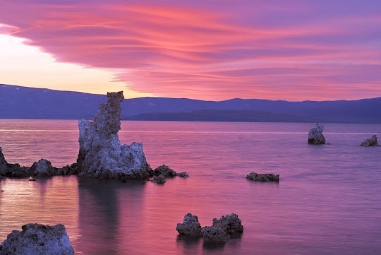
The most unusual feature of Mono Lake are its dramatic tufa towers emerging from the surface. These rock towers form when underwater springs rich in calcium mix with the waters of the lake, which are rich in carbonates. The resulting reaction forms limestone. Over time the buildup of limestone formed towers, and when the water level of the lake dropped the towers became exposed.


But the drop in surface level was not a natural phenomenon. It started in 1941 when the city of Los Angeles began diverting the streams that fed Mono Lake. So much water was drawn away from the lake that the surface level of Mono Lake fell by 45 feet. By 1982 the lake was reduced to 37,688 acres (15,252 ha) having lost 31 percent of its 1941 surface area. As a result, alkaline sands and the once submerged tufa towers became exposed and a land bridge between the shoreline and an island was formed. The island served as a major breeding area for migratory birds. Until now, the island was a safe haven protected by waters all around, but the newly formed land bridge invited predators such as coyotes to the island, who fed on eggs and chicks forcing the breeding colony of birds to abandon the site.

In addition to migratory birds, several other species spend months nesting at Mono Lake, among which are California gulls. After the land bridge to the Negit Island became exposed in the late 1970s, the California gulls have also moved to nearby islets and have established new, and less protected, nesting sites.

A study conducted in 1988 predicted that if the drying of Mono Lake was allowed to continue, by 1999 the salinity of the lake would increase to a level where the productivity of the brine shrimp would begin to decline. Finally by 2012, the existing lake ecosystem could cease to function because the lake salinities would reach such high levels that brine shrimp and brine flies could no longer survive, thus depriving 1.3 million birds of their food source at the lake.

Based on the report, in 1994, the California State Water Resources Control Board issued an order to protect Mono Lake. The goal is to return the lake to the level of 6,392 feet above sea level. As of July 2012, Mono Lake was at 6,383.3 feet above sea level but frequent droughts in the region have made achieving the goal more and more difficult.


NASA Landsat 7 image


Source
READ MORE»

Tarim Desert Highway in Taklamakan Desert, China

The Tarim Desert Highway across the Taklamakan desert, in China, links the cities of Luntai and Minfeng on the northern and southern edges of the Tarim basin. The total length of the highway is 552 km, of which approximately 446 km is built across uninhabited areas covered by shifting sand dunes, 20 metes tall, that frequently bury the highway.

To prevent the highway from getting buried by the encroaching sand dunes, rows of vegetation were planted on both sides of the road to anchor the sand with their roots. A massive irrigation system was constructed that pump water from underground reservoirs to sustain the artificial ecosystem. Hundreds of workers were employed, housed every four kilometers along the road who tend to the short, small-leaved rose willows, sacsaoul and buckthorn and make sure they do not die. The water comes from wells, bored 100 meters deep into an aquifer which sits under the desert, which in turn is fed by the rivers that flow down from the surrounding mountains. Despite the high saline content in the water, the green belt continues to thrive.


A lone pumping station by the side of the Tarim Desert Highway.

For five years the government experimented with various plants that could survive desert conditions. In 1999, a pilot project of sand protection afforestation belt along a 6.3-kilometer section of the highway was completed. In 2001, the project was expanded until a 30.8-km stretch along the highway was afforested. The project was finally approved by the state in 2003. Today, nearly four-fifth of the highway is flanked by 72 to 78 meter-wide tree belt, covering a total area of more than 3,000 hectares.

The Tarim Desert Highway has great economic significance, which is why such expensive and elaborate measures had to be adopted just to keep the highway usable. The highway was built in 1995 to service an essential north-south oil pipeline, that lies underneath the Taklamakan desert. Beneath the shifting sands contains the largest oil-gas field in China. The highway not only allows direct access to resources that lie underneath the Tarim Basin, but also allows transport of goods and resources from the Lunnan Oilfield to the south of the country rather than take a detour around the desert that would encompass hundreds of kilometers. Because the region is entirely uninhabited, a gas station and a few restaurants were built at the halfway point along the desert highway to service travellers.


Satellite image shows part of the Tarim Desert Highway covered by sand.


A gas station in the middle of the desert, along the Tarim Desert Highway.


Source
READ MORE»

Larung Gar - Buddhist Academy in Tibet

Larung Gar Buddhist Academy, also known as Serthar Buddhist Institute, sits in the Larung Valley at an elevation of 4,000 meters, about 15 km from the town Sêrtar, in Sertar County, Garze Prefecture in the traditional Tibetan region of Kham. The academy was founded in 1980 in an entirely uninhabited valley by Jigme Phuntsok, an influential lama of the Nyingma tradition. Despite its remote location, Larung Gar grew from a handful of disciples to be one of the largest and most influential centers for the study of Tibetan Buddhism in the world. Today it is home to over 40,000 monks, nuns and lay-students.

The campus of Larung Gar is enormous. Houses for monks and nuns sprawl all over the valley and up the surrounding mountains. A huge wall through the middle of Larung Gar separates the monk side from the nun side. Monks and nuns are not allowed out of their designated areas except in front of the main monastery assembly hall which is common to both nuns and monks. The houses are all built in a wood style that is traditionally found in this region, and built so close together that they appear almost on top of each other.


One of the most surprising elements of Serthar is that more than half of those who come to study are women. Entry into the relatively small number of nunneries that exist in other areas of Tibet is limited, but Serthar was open to virtually anyone who genuinely sought to become a student of Khenpo Jigme Phuntsok’s ecumenical vision. Another surprise at Serthar is that it attracts ethnic Chinese students as well as students from Taiwan, Hong Kong, Singapore, and Malaysia, who attend separate classes taught in Mandarin, while larger classes are taught in Tibetan.

Reaching Larung Gar is not an easy task. It is quite remote and the nearest large city is Chengdu, which is 650 kilometers away and takes 13 to 15 hours to reach by vehicle. Sertar is also a sensitive area that is often closed to foreign travelers.


Nuns wash clothes at the Serthar Wuming Buddhist Study Institute on November 4, 2006 in Serthar County of Garze Tibetan Autonomous Prefecture, Sichuan Province, China.


A nun holds sutras and a portable stereo as she prepares to listen to the lecture of a master at the Serthar Wuming Buddhist Study Institute on November 4, 2006 in Serthar County of Garze Tibetan Autonomous Prefecture, Sichuan Province, China. 


Lamas listen to a master as they study sutra at the Serthar Wuming Buddhist Study Institute on November 11, 2007 in the Tibetan autonomous region of China.


A nun puts her shoes on a shelf before she enters a Buddhist hall at the Serthar Wuming Buddhist Study Institute on November 11, 2007 in the Tibetan autonomous region of China.


Nuns buy goods outside a store at the Serthar Wuming Buddhist Study Institute on November 11, 2007 in Serthar County of Garze Tibetan Autonomous Prefecture, Sichuan Province, China.


Sources
READ MORE»

10 Beautiful Real Life Fairytale islands

The approximate definition of a real life fairytale island would be that it is small island often covered with lush vegetation, from which emerges a magnificent ancient building. When people say that a place is like something from a fairy tale often they are exaggerating, but that is not the case with these charming islands listed below.


1. Bled Island, Slovenia


Lake Bled is a lake in the Julian Alps in northwestern Slovenia, where it adjoins the town of Bled. The area is a popular tourist destination.


The lake surrounds Bled Island, the only natural island in Slovenia. The island has several buildings, the main one being the pilgrimage church, built in its current form near the end of the 17th century, and decorated with remains of Mediaeval frescos and a rich Baroque equipment.


The church has a 52 m (171ft) tower and there is a stairway with 99 steps leading up to the building. This church is frequently visited and weddings are held there regularly.


Traditional wooden row barges call pletna ferry people to and from the island. More adventurous visitors can rent a boat and row themselves over.


2. Pfalz Island, Germany


Pfalz, the island in the Rhine River, is located in the Rhine Gorge roughly halfway between Mainz and Koblenz. It's about 120 yards (110m) to the left bank, and 80 yards (73m) to the right bank. The valley sides are quite steep-sided, making the river by far the most practical means of transport through this area.


The island is a little less than 100 yards (90m) long, and the amount which is above water depends on the river level. The upstream half of the island shoulders the fortress, which is currently at least 50% ruined. It has an elongated hexagonal footprint. The side facing the left bank, and the upstream end, is currently in a better state of repair than the rest.


The side facing the left bank has some (partially) underwater rocks on which a small pier is built. The downstream half of the island has a tiny copse of trees. A vine grows on the central part.


3. Visovac Island, Croatia


One of the best reasons to visit the gorgeous Krka National Park lies on Visovac island in the middle of Visovac lake.


About 6 km (3.7mi) upstream from Skradin (a small town in the Å ibenik-Knin county), Visovac island is the site of a Franciscan monastery that dates from 1576.


The austere walls and towering bell tower are protected by a circle of cypresses that point to the sky like swords. Beyond the tiny island lies the trout-filled waters of the lake which, in turn, is protected by high karstic cliffs.


The monastery treasures are exhibited in a small museum and outside is a lovely, flowering garden attended by the 10 monks in residence. Visovac island is reachable by boat from Bristane village on the mainland.


4. Heart Island, USA


Heart Island is part of the Town of Alexandria, in Jefferson County, New York State. Boldt Castle, located on Heart Island in the Thousand Islands of the Saint Lawrence River, along the northern border of New York State, is a major landmark and tourist attraction in its region.


Heart Island is accessible by ferry and most of the grounds and buildings can be explored by the public for a fee. Also, there is a U.S. Customs and Border Protection office on Heart Island and visitors coming from Canada require appropriate identification, as visiting the island is considered entering the United States.


Two other buildings on the island are the Power House and the Alster Tower; both are open to the public. The Power House was built to hold a generator to supply the island with power, and now is more of a museum of how electric power was obtained in the early 1900s. The Alster Tower was purposely constructed with slanting and uneven walls, ceilings, and roofs.


5. Wilhelmstein Island, Germany


Wilhelmstein Island is located in Steinhuder Meer (lake), northwestern Germany. Duke Wilhelm of Schaumburg-Lippe (1724-1777) built fortress on this island, for the protection of his rather small county. Wilhelmstein Island is actually an artifical island, based on piles of stones, that had to be carried there by the local fishermen in their boats.


The fortress originally consisted of 16 islands that were later connected. In the fortress Wilhelm established a millitary college. Only once the Wilhelmstein proved useful when in 1787 it was besieged by the Duke of Hessen-Kassel who planned to annex Schaumburg-Lippe and did not succeed.


Plane flying over the fortress Wilhelmstein

Wilhelmstein today is a museum and a popular destination for tourists who visit the Steinhuder Meer.


6. Mont Saint-Michel, France


Mont Saint-Michel is a rocky tidal island and a commune in Normandy, France. It is located approximately one kilometre (just over half a mile) off the country's north-western coast, at the mouth of the Couesnon River near Avranches.


The population of the island is 44, as of 2009. The island has held strategic fortifications since ancient times, and since the 8th century AD been the seat of the monastery from which it draws its name. The Mont-Saint-Michel and its bay are part of the UNESCO list of World Heritage Sites. More than 3,000,000 people visit it each year.


Mont Saint-Michel was previously connected to the mainland via a tidal causeway, i.e. a trackway covered at high tide and revealed at low tide. But today, this island is connected to the mainland by an elevated light bridge that was built in the past few years.


7. Trakai Island Castle, Lithuania


Trakai Island Castle is located on an island in Lake GalvÄ—, Lithuania. The castle is sometimes referred to as "Little Marienburg".


The construction of the stone castle was begun in the 14th century, and around 1409 major works were completed. Trakai was one of the main centres of the Grand Duchy of Lithuania and the castle held great strategic importance.


The Trakai Island Castle today is the hub where plenty of concerts, events and festivals are held. In Lithuania, the castle is also considered to be one of the most beautiful historical monuments ever. In 1962, a museum was opened here. During the year Trakai Island Castle attracts up to 300 000 visitors.


In Trakai, tourists are enjoying resting by the waterside, a yacht or motorbike ride, swimming, fishing, camping or simply a quiet time in a cafe on the bank of Lake Galve. In June, Lake Galve holds International Rowing Regatta “Amber oars”.


8. Loreto Island, Italy


Loreto Island, is located on Lake Iseo, Italy. Otherwise, Lake Iseo or Sebino is the fourth largest lake in Lombardy, Italy, fed by the Oglio river.


The island L’isola di Loreto (in Italian) is the smallest island of the lake. Situated on the north side of Montisola (larger island).


It is of private property. In 1400 a cloister was built here for the Sisters of S.Chiara. Today there is a castle in New Gothic stile, a park and a small port.


9. Dark Island, USA


Dark Island, a prominent feature of the St. Lawrence Seaway, is located in the lower (eastern) Thousand Islands region, near Chippewa Bay. It is a part of the Town of Hammond, in St. Lawrence County, New York.


A historic landmark here, "The Towers" was long known as Dark Island Castle until recently renamed "Singer Castle". The island itself sits only a few yards south of the Canadian-United States border that runs along the river. Because of its proximity to Canada, it was used for rum-running during prohibition in the United States.


The south side of the island is only about one-hundred feet (30m) from the shipping channel, and cargo ships frequently pass the island. Because of the depth of the channel on one side, and the relative shallowness on the other, it is very good for sport fishing of Largemouth Bass and Northern Pike (fish species).


10. Pontikonisi, Greece

Mouse Island (Pontikonisi) in background

This small beautiful island covered with pine trees which is situated between Agriovotanos and Ellinika is called Pontikonisi. Only a few places in Greece have been photographed as much as this small piece of land which is the trademark of Corfu Island.


This virgin biotope houses seals, dozens of birds and it is also a location rich in fish. Its existence is recorded in all the old maps and it is said that in the area around it the famous naval battle of Artemision took place.


Pontikonisi is the home of the Pantokrator monastery. It is the white stone staircase of the Monastery that when viewed from afar gives the impression of a mouse tail that gave the island its name, Mouse Island, that's what Pontikonisi means in Greek.


Source
READ MORE»