Marketplace With a Railway Track Through it

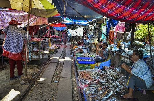
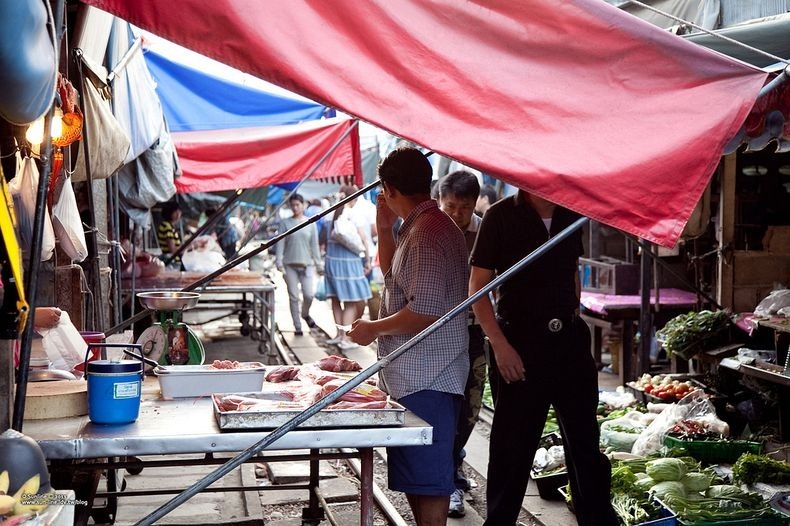
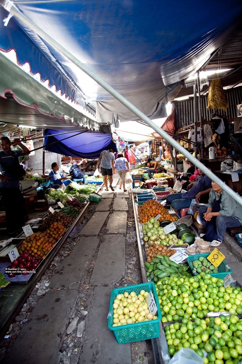
Maeklong Railway Market, located in Samut Songkhram, Thailand, around 37 miles west of Bangkok, looks like any other open-air market in Asia. There are tropical fruits and vegetables such as lychee, durian, and mango in big brightly colored piles, variety of dried spices, pastes and herbs, freshly caught seafood and other local foods. The crowd weave their way around in between vendors, picking up whatever they need for the day. The market is sheltered by low-hanging awnings/umbrellas and if you look closely, you will notice that you are actually walking on train rails.

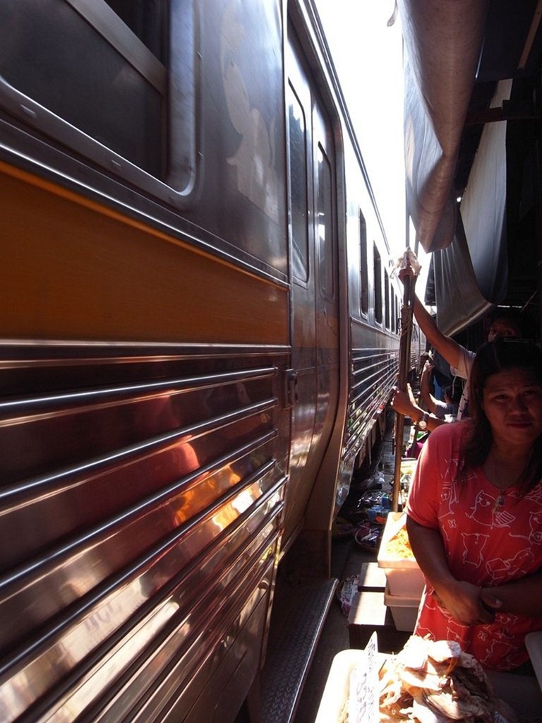
Then a piercing siren sounds and in a flash the market transforms - the shoppers disappear and the stallholders whip away their produce. One moment you see the locals shopping for their vegetables and the next moment the vendors will scoop up their baskets and boxes and anything that lies over the track. The market comes to a standstill as all the vendors hold on to the poles supporting their awnings to make way for the train to pass. It is such a tight squeeze that the train travelling at about 15mph almost touches the fruits, vegetables and everything else at the marketplace as it passes through.


Once the train is gone, the vendors push back the stalls and awnings into position and everything goes back to normal as if nothing has happened. After all the market has been here for generations way before when the railway was set up in 1905.

Thais call this place Talad Rom Hoop Market which literally translates to “Market Umbrella Pulldown”. You will understand the name once you see the video.


Trains runs through the Maeklong Railway Market 7 times a day, 7 days a week. In the morning, the train passes by the market 4 times. The train arrives at 0840hrs from Ban Laem Station and departs from Maeklong (Samut Songkram) Railway Station at 0900hrs. The next train arrives at 1120hrs from Ban Laem and depart from Maeklong (Samut Songkram) Railway Station at 1130hrs. In the afternoon, the train passes by the market 3-4 times. The train arrives at 1430hrs from Ban Laem and departs from Maeklong (Samut Songkram) Railway Station at 1530hrs. The next train arrives at 1740hrs from Ban Laem and may or may not depart from Maeklong (Samut Songkram) Railway Station. Do note that the train schedule is subject to change so check the schedules with the train station before planning your journey to Maeklong.


Source

READ MORE»

Snow Roller

Snow roller is a rare meteorological phenomenon in which large cylinders of snow are naturally formed as chunks of snow are blown along the ground by wind, picking up material along the way, in much the same way that the large snowballs used in snowmen are made. But unlike snowballs made by people, snow rollers are typically cylindrical in shape, and are often hollow. The inner layers, which are the first layers to form, are weak and thin compared to the outer layers and can easily be blown away, leaving what looks like a doughnut or Swiss roll.

Snow rollers happen with the combination of lying snow and high wind speeds, mostly in North America and Northern Europe, and they can be as small as a tennis ball or they can be as large as two feet across – depending on how strong the wind is and how smooth the surface of the snow is. Gravity can also assist snow roller formation. An inclined surface often needs just a little shove from the wind to get snow rollers in motion.


Frank Barrow, a lecturer in meteorology at the Met Office, described the exact science behind the formations.

They start off with a nice thick layer of snow, with the top snow just on the point of melting either because of general temperature or sunshine on the surface. The top snow layer becomes a bit sticky and you then need a fairly strong wind. The sticky layer can be peeled off the colder and more powdery snow underneath by the wind, forming a roll.

The rolls are not hollow to begin with, as a number of layers build up as the roll gets larger the further it is blown. However, the inner layers are weaker as they are formed first and are easily blown away. Eventually the rolls become too big to be blown any further or come to rest against vegetation or at the bottom of a hill.


Source
READ MORE»

10 Amazing Volcanic Plugs & Natural Monoliths

A volcanic plug, also called a volcanic neck, is a volcanic landform created when magma hardens within a vent on an active volcano. A natural monolith is a mountain or large rock formation consisting of a single massive stone. Both types of these geological structures are similar in that they are often steeply rising above the surrounding terrain. The unusual appearance and the buildings which are often located on these structures, amaze visitors and attract them to come back again.


1. Saint Michel d'Aiguilhe, France


The Chapel of Saint-Michel d'Aiguilhe is a fascinating little pilgrimage chapel perched atop a rocky needle of volcanic formation jutting dramatically high into the sky, at a place near Le Puy-en-Velay in France.


The basalt needle on which the chapel is built rises approximately 280 feet (85 m), and is reached by 268 stone steps that wind their way up the side of the rock. The chapel is surrounded by a walkway that provides a beautiful view of the city with its Puy Notre Dame Cathedral and the old bridge crossing the cusps terminal.


The chapel was built in 962, to celebrate the return of Saint James from the pilgrimage. In 1429 the mother of Joan of Arc, Isabelle Romée, was said to have come to the site to pray.


2. El Peñón de Guatapé, Colombia


El Peñón de Guatapé is a monolithic formation located at the town and municipality of Guatapé, 1 km (0.6 mi) inside the city limits in Antioquia department, Colombia.


The rock was first climbed officially on July 1954. In 2006, Luis Villegas, Pedro Nel Ramírez and Ramón Díaz climbed the rock in a five-day endeavor, using sticks that were fixed against the rock's wall. A new species of plant was found on the top of the rock, subsequently named Pitcairma heterophila by a German scientist.


A viewing spot was built on top of the rock, where it is possible to acquire handicrafts, postcards, and other local goods. It is possible to see the 500 km (310 mi) shore-perimeter dam. There are 740 steps to the top of the viewing spot. In the 1940s, the Colombian government declared it a "National Monument".


At its highest part, on the rear (southeast side), it has an elevation of 2,135 metres (7,005 ft) over sea level. With an average temperature of 18 °C (64 °F). The "Peñol" has 185 cubic metres (6,500 cu ft) of rock mass and it is 385 metres (1,263 ft) long, with an approximate weight of 10,000,000 tonnes (11,000,000 tons).


3. Trosky Castle, Czech Republic


Trosky Castle is a castle ruin located some 10 km (6 mi) south of Semily, Liberec Region, Czech Republic. It is one of the most famous Czech castles and is situated on the summits of two basalt volcanic plugs.


On the lower peak (47m or 155ft) is the two-storey structure called Baba (Old Woman), and on the higher outcrop (57m or 187ft) is the four-sided structure known as Panna (Virgin). The castle is a landmark which cannot be missed in the countryside known as Český ráj (Bohemian Paradise).


The castle was established by Čeněk of Vartenberk (a commander in the Hussite Wars) in the second half of the 14th century. Two towers were constructed, one on top of each rock, and various residential buildings and outhouses erected between them. Three rings of fortified walls protected the complex.


4. Katskhi Pillar, Georgia


The Katskhi pillar is a natural limestone monolith located at the village of Katskhi in western Georgian region of Imereti, near the town of Chiatura. It is approximately 40 metres (130 ft) high, and overlooks the small river valley of Katskhura, a right affluent of the Q'virila.


The rock, with visible church ruins on its top surface of around 150 sq m (1,600 sq ft), has been venerated by locals as the Pillar of Life. It remained unclimbed by researchers and unsurveyed until 1944 and was more systematically studied from 1999 to 2009. These studies revealed the early medieval hermitage, dating from the 9th or 10th century.


Religious activity started to revive in 1995, with the arrival of the monk Maxim, a native of Chiatura. Between 2005 and 2009, the monastery building on the top of the pillar was restored with the support of the National Agency for Cultural Heritage Preservation of Georgia. The rock is now accessible through an iron ladder running from its base to the top.


5. Zuma Rock, Nigeria


Zuma Rock is a large monolith located in Niger State, Nigeria. It is just north of Nigeria's capital Abuja, along the main road from Abuja to Kaduna, and is sometimes referred to as "Gateway to Abuja." It is depicted on the 100 naira bill (national currency). Zuma Rock is 725 m (2,400 ft) above its surroundings.


As the tourist gets closer, a human like face becomes visible with engravings representing the eye sockets, the nose and the mouth on the side of the rock that faces the Abuja - Kaduna express road. Zuma Rock represents a beautiful and unique natural work of rock formation. If offers a good environment for picnicking and relaxation. A Five Star Hotel, Zuma Rock Resort International Limited is being constructed near the rock.


6. Sugarloaf Mountain, Brazil


Sugarloaf Mountain, is a peak situated in Rio de Janeiro, Brazil, at the mouth of Guanabara Bay on a peninsula that sticks out into the Atlantic Ocean. Rising 396 metres (1,299 ft) above the harbor, its name is said to refer to its resemblance to the traditional shape of concentrated refined loaf sugar.


The mountain is only one of several monolithic morros (hills) of granite and quartz that rise straight from the water's edge around Rio de Janeiro. A glass-walled cable car, capable of holding 65 passengers, runs along a 1400-metre route (4,600 ft) between the peaks of Pão de Açúcar and Morro da Urca every 20 minutes.


To reach the summit, passengers take two cable cars. The first ascends to the shorter Morro da Urca, 220 meters (720 ft) high. The second car ascends to Pão de Açúcar. The Italian-made bubble-shaped cars offer passengers 360-degree views of the surrounding city. The climb takes three minutes from start to finish.


7. Sigiriya, Sri Lanka


Sigiriya (Lion's rock) is a place with a large stone and ancient rock fortress and palace ruin in the central Matale District of Central Province, Sri Lanka, surrounded by the remains of an extensive network of gardens, reservoirs, and other structures. A popular tourist destination, Sigiriya is also renowned for its ancient paintings (frescos), which are reminiscent of the Ajanta Caves of India. It is one of the eight World Heritage Sites of Sri Lanka.


Sigiriya may have been inhabited through prehistoric times. It was used as a rock-shelter mountain monastery from about the 5th century BC. According to the chronicles as Mahavamsa (a historical poem) the entire complex was built by King Kashyapa (477 – AD 495), and after the king's death, it was used as a monastery until 14th century.


8. Pico Cão Grande, São Tomé and Príncipe


The Pico Cão Grande (Great Dog Peak) is a landmark needle-shaped volcanic plug peak in São Tomé and Príncipe, located in the south of São Tomé Island in Obo National Park.


It rises dramatically over 300 m (1,000 ft) above the surrounding terrain and the summit is 663 m (2,175 ft) above sea level. Clouds and fog often cover the peak of this amazing geological structure.


9. Penyal d'Ifac, Spain


The Penyal d'Ifac is a massive limestone outcrop emerging from the sea and linked to the shore by rock debris. It is home to numerous rare plants, including a number of endemic species, and over 300 species of animals, and a nesting site for colonies of sea birds and other birds.


Rising to 332 metres (1,100 ft) high, the rock is a striking visual feature of the Mediterranean coastline. Behind the rock is a large lagoon cut off from the sea by strips of sandy beach and extending inland to the coastal mountains. The wetland area around the lagoon is all that remains of the formerly much more extensive wetlands of the Marina Alta.


10. Devils Tower, USA


Devils Tower is an igneous intrusion or laccolith located in the Black Hills near Hulett and Sundance in Crook County, northeastern Wyoming, above the Belle Fourche River. It rises dramatically 1,267 feet (386 m) above the surrounding terrain and the summit is 5,114 feet (1,559 m) above sea level.


It was the first declared United States National Monument, established on September 24, 1906, by President Theodore Roosevelt. The Monument's boundary encloses an area of 1,347 acres (545 ha). About 400,000 visitors a year visit this beautiful formation.


Source
READ MORE»