Cahokia - Oldest Great Civilization in US?

When we studied Native American history in school, we learned about many tribes. Chances are you don’t remember learning of Cahokia, a long-extinct civilization originally near what is now Collinsville, Illinois. First established around AD 600 and inhabited by a unique indigenous people, Cahokia was a civilization comprised of about 50 communities over 2,200 acres.

They built 120 earth mounds – some over ten stories tall – in the largest prehistoric earthen construction site north of Mexico. The Cahokians were advanced people who did not appear to be related to any major known Native American tribes. By 1250, Cahokia’s population rivaled Paris and London; at its peak in 1300, Cahokia numbered an estimated 40,000 people. It wasn’t until 1800 that a modern U.S. city would finally surpass that number.

After 1300, the population declined for unknown reasons and the city would lie vacant for another century.


What makes Cahokia so fascinating is how little we know about it. Despite being advanced for a Native American people, they did not leave written records. Instead we have symbols on pottery, stone, and wood.

Since we have no Rosetta stone, much of the original city – including its name – is still unknown. The Cahokia name was actually given to the area in the late 1600s, named for the Native Americans that settled nearby many centuries later.
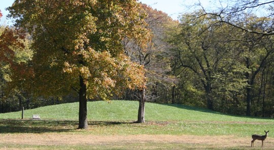
Cahokia Mounds
The most striking feature of Cahokia is the earthen mounds. Experts believe thousands of workers moved an estimated 55 million cubic feet of earth over a span of several decades. The workers didn’t have complex technology or building techniques, so these weren’t exactly the pyramids of Egypt.

Laborers carried earth up each mound by hand in woven baskets, making multiple trips each day.


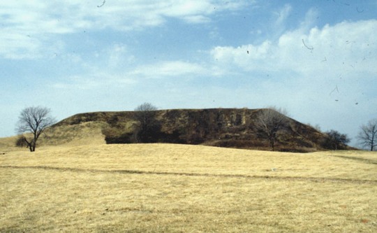
The largest is called Monks Mound and is assumed to have been the center of the Grand Plaza of Cahokia – the plaza itself occupying 40 acres. Monks Mound is 92 feet (28 m) high, 951 ft (290 m) long, 836 ft (255 m) wide, and covers 14 acres.

The top of Monks Mound had a large, flat reinforced area which historians believe was home to a massive 5,000 square-foot temple about 50 feet tall. This temple was thought to have been the residence of the paramount chief and was said to be visible from anywhere in Cahokia.

Of the 120 earthen mounds the Cahokians constructed, only 80 remain today. Unfortunately farming and industrialization of the area has taken its toll: an estimated 40 mounds have been leveled or razed over the last 200 years for various reasons.

Of the 40 since-razed mounds, 29 have been located by archaeologists.
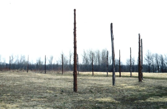


Woodhenge
The second most significant feature of Cahokia was the Woodhenge. Not as well-known as the English Woodhenge (2 miles from Stonehenge), the America version seemed to serve the same purpose. Archaeologists who discovered the Woodhenge noted the wood posts symbolized the earth and the four cardinal directions, with a pattern that seemed to follow the sun.

The Woodhenge was discovered adjacent to Monks Mound, and some time later another Woodhenge was discovered by Mound 72.


Mass Grave
Mound 72 might just be the most significant archaeological discovery at the site. During an excavation, human remains were discovered: a man in his 40s experts believe might have been an important Cahokian chief.

Below his burial site experts found more than 250 other skeletons, sixty percent of which are believed to have been sacrificial killings or ritual executions. This was estimated due to countless bodies missing hands and skulls, more than fifty 21 year-old women found in neatly-separated layers, and finally a mass burial grave with over 40 men and women who appear to have been violently killed.

In fact evidence supports some were alive when they were buried, attempting to claw their way out of the mass of dead bodies.

Excavations around Mound 34 have discovered an ancient Cahokia copper workshop. This is significant because prior to this discovery, experts did not definitively know how early copper technology starting appearing around the United States.


700 years after Cahokia and the land still appears exhausted


Decline
Perhaps the most mysterious part of Cahokia was how it came to end; historians simply don’t know. The primary hypotheses are erosion from over-hunting and deforestation, invasion from outside tribes, disease, or abandonment due to political collapse.

The civilization was thought to have prospered for nearly 800 years, and given how primitive farming techniques were at the time it’s no surprise the land was eventually exhausted. Trees would have been sparse and pollutants from centuries of crude copper operations would contaminate the surrounding soil, making any crops poisonous even before harvest.

Defeat through invasion was possible but less likely considering little has been found of battle, and no mass civilian graves have been discovered – something likely to be found had the entire population been killed during a siege.

Archaeologists in Cahokia


We may never know what happened to Cahokia, but given its important place in North America’s history it is important we don’t forget it.

Cahokia is one of only twenty-one UNESCO World Heritage Sites in the United States, and is the largest archaeological site in the country. And to think so few have ever heard of it.


Source
READ MORE»

The Last House on Sinking Island

Holland Island is located in the Chesapeake Bay in Holland Strait, between Bloodsworth Island and Smith Island, six miles west of Wenona, Maryland. The island was once about five miles long and one and a half miles wide, and inhabited by watermen and farmers in a thriving fishing community. But over the decades, rising Bay waters and natural sinking of the land ate away at the island until it was nothing but a blotch of land in the sea. The last house on Holland Island stood defiantly for over century until its collapse in October 2010.

Holland Island was originally settled in the 1600s, taking its name from the first owner of the property Daniel Holland. By 1850, the first community of fishing and farming families developed on the island. By 1910, the island had about 360 residents, making it one of the largest inhabited islands in the Chesapeake Bay. At its peak, the island had 70 homes, several stores, a post office, two-room school with two teachers, a church, and a community center. It had its own baseball team and a doctor. The islanders supported themselves mainly by dredging for oysters, fishing for shad and crabbing. Their fleet of workboats included 41 skipjacks, 10 schooners and 36 bugeyes, some of which were built on the island.


The last house on Holland Island in October 2009.

By 1920 the erosion from wind and tide was taking its toll on the island's bay side. Like other Chesapeake Bay islands, Holland Island is primarily made up of clay and silt, not rock, making it prone to erosion. The islanders tried to import stones to build walls along the shore and even sank some old boats to slow the erosion, but lacking modern equipment and techniques, their efforts failed. Most of the residents of Holland Island were forced to leave, and many others disassembled their houses and other structures and took them to the mainland. In August 1918, a tropical storm hit the Bay, nearly destroying the church and prompting the last families to leave by 1922. More and more houses started disappearing under the water, until all but one remained.

Holland Island sat abandoned and neglected until 1995 when Stephen White, a Methodist minister and former waterman who grew up on the island, purchased the house for $70,000 and tried to preserve its legacy by creating the Holland Island Preservation Foundation. Over the next 15 years, Mr White spent nearly $150,000 in his efforts to save the island by building up the shoreline with sand bags, timber, even an old barge.

Stephen White’s valiant efforts went in vain. In mid-October of 2010, the house finally succumbed to the elements and collapsed in a heap. Over the next several months the water took away the wreckage, piece by piece until a year later the rising waters had almost completely engulfed Holland Island.


Holland Island on October 18, 1953


Sources:
READ MORE»

Mount Rainier's Shadow - Up in the Clouds

All objects, big or small, cast shadows and so do mountains. However, one particular peak displays a peculiar behavior – it cast shadows not on the ground, but up in the clouds. How does that happen?

Mount Rainier is a massive volcanic peak located 87 km southeast of Seattle in the state of Washington, United States, that climbs to a height of 4,392 meters. There are no other mountains anywhere near that height in the surroundings, so it is topographically the most prominent mountain in the entire United States. On clear days the peak dominates the southeastern horizon and can be seen from as far away as Portland, Oregon and Victoria, British Columbia. But on a cloudy morning, when the cloud heights are just right, the rising sun can catch the peak from below and cast a long shadow on the underside of the cloud.


This only happens during the fall and winter when the sun rises farther to the south, and is in the exact position where Mount Rainier blocks the first rays of morning light. This particular image was shot on the morning of October 26th, 2011.


Photo taken on December 31, 2012


Source
READ MORE»

Glass Gem Corn - Colorful and Real Corn

These multicolored kernels of corn that look like glass beads belong to a specially bred variety, aptly named Glass Gem Corn, and they can be actually grown from seeds. Glass Gem corn was developed by Carl Barnes, a part-Cherokee farmer living in Oklahoma, who noticed that every so often, a cob showed signs of unusual coloring shining through. Barnes collected and saved those seeds, and thanks to his uncanny knack for corn breeding and many years of painstaking effort, Glass Gem corn was born.


When Barnes approached old age, he bestowed his precious seed collection to his friend Greg Schoen and also shared with Schoen the process of breeding the Glass Gem corn. In 2010 Greg decided to move. While moving, he made the determination that he needed to find someone to store and protect his seed collection so that it didn’t get lost or ruined in the moving process. He decided to store the seeds with Seeds Trust, a small seed company in Arizona, ensuring Barnes' spectacular collection of Glass Gem corn seeds wouldn't face the risk of getting lost when he relocated. Curious about the seeds with the peculiar name of Glass Gems, Bill McDorman, owner of Seeds Trust at the time, decided to plant a few of the seeds in his own garden. He was amazed at what the seeds produced.

"I was blown away. No one had ever seen corn like this before,” McDorman told Native Seeds/SEARCH, a nonprofit organization he founded to protect and preserve the agricultural heritage of Native Americans.

The organization now sells Glass Gem seeds through its website for $7.95 (£4.90) per packet, although they are so highly sought-after that they are frequently sold out. The corn can be used to make flour or popcorn, although it is not recommended to eat it straight off the cob.


Source
READ MORE»

15 Strange Beaches

Sandy stretches of gray, brown or even white are the world's norm. Even rocky beaches or those with sheer cliffs barring passage for everyone save the bravest adventurers are not rare. But there are other beaches on Earth that look like they belong on another planet or almost feel like they are on another planet. These unique beaches are some of the best treats nature has to offer.

1. Papakolea Beach, Hawaii, USA


Papakōlea Beach (also known as Green Sand Beach or Mahana Beach) is a green sand beach located near South Point, in the Kaʻū district of the island of Hawaiʻi. One of only two green sand beaches in the World, the other being in Galapagos Islands. It gets its distinctive coloring from the mineral olivine, found in the enclosing cinder cone.


Papakōlea Beach is located in a bay half circled by Puʻu Mahana (a cinder cone) and associated with the southwest rift of Mauna Loa. Since its last eruption, the cinder cone has partially collapsed and been partially eroded by the ocean.


The beach is sometimes named after the cinder cone, and sometimes after the area of land called Papakōlea, which comes from papa kōlea, which means plover flats in the Hawaiian language. Papakōlea is the area near the crater where the Pacific Golden Plover (Pluvialis fulva) are sometimes seen in winter.


It is surrounded by pasturelands and is only accessible on foot or by using a vehicle equipped with four-wheel drive. To actually reach the beach, an additional climb down the cinder cone is required.


2. San Alfonso del Mar Beach, Chile


This beach is located between the largest artificial pool and the largest ocean on the planet Earth. San Alfonso del Mar Beach is an integral part of the luxurious resort of the same name.


Seeing as San Alfonso del Mar fronts a huge beach and the Pacific Ocean, it seems an odd spot for the world's largest swimming pool. But the pool's remarkable spaciousness complements the ocean beyond rather effortlessly, and jumping in the pool's 79°F (26°C) water is a much more tempting prospect than venturing into the 63°F (17°C) seawater nearby, with its dangerous waves and currents.


The resort complex on Chile's central coast resembles a modern Mayan city, with pyramidlike apartment buildings towering above the colossal saltwater pool.


Well, since it's over half a mile (1 km) long and holds about 66 million gallons of water, it's more like a lake. Lining the pool are white-sand beaches, palm trees, and docks for the sailboats that ply the gin-clear water.


3. Maho Beach, Sint Maarten


Maho Beach is a beach on the Dutch side of the Caribbean island of Saint Martin, in the country of Sint Maarten. It is famous for the Princess Juliana International Airport adjacent to the beach.


Arriving aircraft must touch down as close as possible to the beginning of Runway 10 due to the short runway length of 2,180 metres (7,150 ft), resulting in aircraft on their final approach flying over the beach at minimal altitude.


Due to the unique proximity of low flying airliners, the location is very popular with plane spotters. This is one of the few places in the world where aircraft can be viewed in their flightpath just outside the end of the runway. Watching airliners pass over the beach is such a popular activity that daily arrivals and departures airline timetables are displayed on a board in most bars and restaurants on the beach, and the Sunset Bar and Grill has a speaker on its outside deck that broadcasts the radio transmissions between pilots and the airport's control tower.


There is a danger of people standing on the beach being blown into the water because of the jet blast from aircraft taking off from runway 10. The local government warns that closely approaching and departing aircraft can "result in serious injury". An additional fence has been added recently behind runway 10, in order to prevent people from hanging on to the main fence surrounding the runway to experience being blasted by the jet flow.


4. Ocean Dome, Japan


This is an artificial beach constructed in the Seagaia resort along the coastal highway outside the city of Myazaki in Japan it has a fully controlled indoor climate throughout the year.


The Ocean Dome, which was a part of the Sheraton Seagaia Resort, measures 300 meters (1000ft) in length and 100 meters (330ft) in width, sported a fake flame-spitting volcano, artificial sand, artificial palm trees and the world's largest retractable roof, which provided a permanently blue sky even on a rainy day.


The air temperature was always held at around 30 degrees Celsius (86°F) and the water at around 28°C (82,5°F). The volcano becomes active every 15 minutes and spews fire every hour, and incredible waves lashes the beach for surfers’ delight. The beach can accommodate 10,000 tourists, and the kicker is that there's an actual beach only 300 meters (1000ft) away. It opened in 1993, and visitor numbers peaked in 1995 at 1.25 million a year. The Ocean Dome was officially closed on October 1, 2007 as part of a renovation and partial re-branding of the resort.


5. Plage de Saleccia, France


The beach near St-Florent, on the French island of Corsica, is known as Plage de Saleccia and it is a long and undeveloped expanse of dazzling white sand.


Saleccia, like most of the beaches in the “desert des Agriates”, plays hard to get with its difficult access. The long walk (12 km or 7.5mi) or drive with terrain vehicle, also prevent overcrowding of this fabulous white sand and transparent water place surrounded by sand dunes.


It is one of the undisputed scenic beaches of the island. Access by boat is also offered from the harbour of St Florent. Saleccia is also place where chestnut-coloured cattle often snooze alongside the sunbathers.


These cows have a habit of visiting Saleccia beach all year round, so they come here also during the summer season when the beach is full of tourists.


6. Pink Sand Beaches, Bermuda


Bermuda has some magnificent large and small beaches. Beach sand is not volcanic but from finely pulverized remains of calcium carbonate shells and skeletons of invertebrates such as corals, clams, forams and other shells.


Beaches begin with tiny single-celled animals, Foraminifera, in particular, homotrema rubrum - or forams - dark red skeletal animals that grow profusely on the underside of Bermuda's coral reefs. When the red forms die, the skeletons plummet to the ocean floor. Wave action erodes the forams. They become mixed with other debris on the seabed such as the white shells of clams, snails and sea urchins.


It is at that time that Bermuda's white sand takes on its characteristic pink hue. Bermuda is one of the northernmost areas in the Western Hemisphere (but not the northernmost place in the world) for coral reefs. In Bermuda, see the contrast of pink sand, turquoise water between the shoreline, outlying reefs, and dark blue of the ocean beyond the reefs or land.


The sand in Bermuda is exceptionally fine. Beaches in Bermuda are often favored for weddings. Most beaches are on the South Shore, but a few are on the North Shore.


7. Playa de Gulpiyuri, Spain


Playa de Gulpiyuri is a flooded sinkhole with an inland beach located near Llanes, Spain around 100 m (330ft) from the Cantabrian Sea.


Roughly 40 meters (130ft) in length, it is fully tidal due to a series of underground tunnels carved by the salt water of the Cantabrian Sea which allows water from the Bay of Biscay to create small waves.


It is a popular tourist destination, natural monument, and part of Spain's Regional Network of Protected Natural Areas.


8. Hot Water Beach, New Zealand


Hot Water Beach is a beach on the east coast of the Coromandel Peninsula, New Zealand, approximately 12 kilometres (7.5mi) south east of Whitianga, and approximately 175 kilometres (110mi) from Auckland by car. Its name comes from underground hot springs which filter up through the sand between the high and low water tidal reaches.


The beach is a popular destination both for locals and tourists visiting New Zealand. Annual visitor numbers have been estimated at 700,000, making it one of the most popular geothermal attractions in the Waikato Region.


Within two hours either side of low tide, it is possible to dig into the sand allowing hot water to escape to the surface forming a hot water pool. The water, with a temperature as hot as 64°C (147°F), filters up from two underground fissures located close to each other. These natural springs can be found on the beach opposite the off-shore rocks. Visitors often dig large holes and relax and soak in the thermal water. Many visitors bring a spade and bucket with them. Spades can also be hired from the nearby surf shop.


9. Hidden Beach on Marieta Islands, Mexico


Protected from the intrusion of the world outside, the hidden beach of Marieta Islands, Puerto Vallarta is a world of its own. Located just a few miles off the coast of Mexico, close to Bandera bay, Marieta Islands are archipelagos that were formed as a result of volcanic activity. The islands have remained almost secluded ever since. It was only recently that recreational aspect of the place was discovered following development of an extremely exclusive marine ecosystem that makes this place just as unique as thrilling.


The water along the hidden beach Marieta Island, Puerto Vallarta is a crystal clear blue mass of pure bliss. Of the marine wildlife available to view in the place, Humpback whale, sea turtles and dolphins are just a few of the most magnificent examples. Travelers can also enjoy a powerboat trip to the hidden beach, Marieta Island, Puerto Vallarta taking in the scenery along the way.


The hidden beach, Marieta Islands, Puerto Vallarta is an intriguing site in its own accord. The beach remains cut off from rest of the group of islands. And for those who stumble across the place, the surprises held are immense. The beach is considered to possess an abundance of reef fish, with about 103 different species moving around in the clear blue waters of the beach.


10. Loango’s Wild Forested Beach, Gabon


This forested beach is located in Loango National Park in western Gabon. Loango’s wild forested beach is one of the few places in the world where great mammal herds still have access to the sea, and one of the last places in the world with Hippopotamus in the surf. Buffalo and Forest Elephant herds graze on the coastal grasslands and wander on the beach.


Surfing hippo in Atlantic Ocean

Even gorilla families are occasionally seen foraging in beachside trees. Many of these beaches provide significant habitat for migrant shorebirds, including African Skimmers and Damara Terns, both with populations that are dropping quickly elsewhere in Africa.


African forest buffalo on the beach

With hunting bans in the park area, Loango’s animals are rapidly acclimating to people, thus becoming more visible to tourists. Quiet walks with trained ecoguides will provide opportunities for tourists to see gorillas, chimps, monkeys, duikers, and hundreds of forest birds.


11. Airport Beach, UK


Barra Airport is probably the only airport in the world where planes land on the beach. BRR is situated in on the wide beach of Traigh Mhor, on Barra island, in the Outer Hebrides, Scotland. If you want to fly here commercially you will want to book with British Airways, which flies to Barra from Glasgow and Benbecula.


The airport is literally washed away by the tide once a day, and if you arrive on a late afternoon flight, you may notice a couple of cars in the parking lot with their lights on, which provides pilots some added visibility, since the airport is naturally lit.


Needless to say you probably don't want to hang out at Barra Airport beach, unless you are a aviation junkie, in which case Barra Airport has a fool proof system, as sign that reads: "Keep off the beach. When the windsock is flying and the airport is active."


12. Chandipur Beach, India


Have you seen the sea disappear in front of your eyes? A unique phenomenon rarely seen anywhere else, the sea recedes by as much as five kilometres (3 mi) every day on the Chandipur beach in eastern India, not just enthralling the onlooker but also offering an opportunity to literally walk into the sea.


The Fisherman at Chandipur beach

At the occurrence of low tide tourists are able to explore the seabed, complete with shells, driftwood and little red crabs. Due to the unique circumstances, the beach supports bio-diversity. Horseshoe crab is also found here on the beach towards Mirzapur, the nearby fishing market and community at the confluence of the Budhabalanga River.


A lot of modern government and private hotels are available here at affordable cost. Tourists visiting the place never like to go back.


13. Scala dei Turchi, Italy


The Scala dei Turchi (Italian: "Stair of the Turks") is a rocky cliff and beach on the coast of Realmonte, near Porto Empedocle, southern Sicily, Italy. It has become a tourist attraction due to its unusual white color.


The Scala is formed by marl, a sedimentary rock with a characteristic white color. It lies between two sandy beaches, and is accessed through a limestone rock formation in the shape of a staircase, whence the name. The latter part of the name derives from the frequent raids carried on by Turks.


In August 2007, the municipality of Realmonte applied for the inclusion of the Scala dei Turchi (together with the nearby Roman Villa Aurea) in the UNESCO Heritage List.


14. Bowling Ball Beach, USA


On the Californian coast is a town called Mendocino. Nearby is a coastal feature called Schooner Gulch, and this is where you can feast your eyes on what has become known as the 'Bowling Ball Beach'.


Thousands of rocks appear to have gathered together to defy the tides like an army of small boulders. The weird thing is that these boulders are uniform in size and shape, as well as in their spacing, though man has nothing to do with it.


The explanation is simple and purely geological in nature. Over thousands of years, this has eroded away under the constant onslaught of the Pacific Ocean, forming the cliffs that line the shore behind the beach and leaving the tougher 'bowling balls' behind.


This may not seem like much of a hotspot for visitors, but the uniqueness of it makes the effort well worth it. You may see things more breathtaking than this incredible bowling ball beach, but you'll never see anything quite like this anywhere else.


15. Glass Beach, USA


Glass Beach is a beach in MacKerricher State Park near Fort Bragg, California that is abundant in sea glass created from years of dumping garbage into an area of coastline near the northern part of the town.


The beach is now frequently visited by tourists. Collecting is not permitted on the park's beach, although sea glass can be found on other local beaches outside the park boundary. A Glass Festival is held annually on Memorial Day weekend.


Thousands of tourists visit Fort Bragg's glass beaches each day in the summer. Most collect some glass. Because of this and also because of natural factors (wave action is constantly grinding down the glass), the glass is slowly diminishing. There is currently a move to replenish the beaches with discarded glass


Source
READ MORE»