Ice Volcanoes in Great Lakes

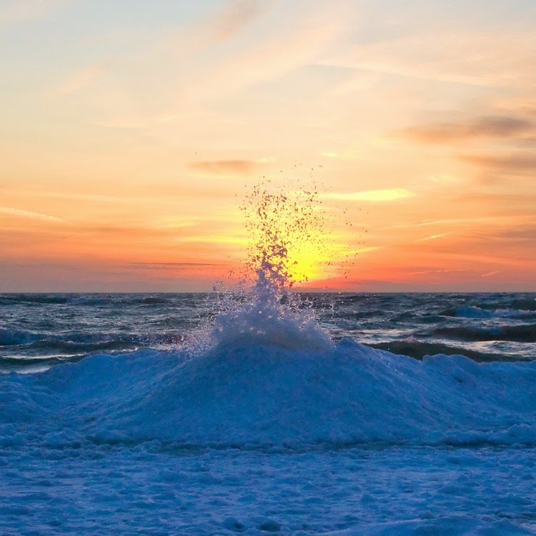
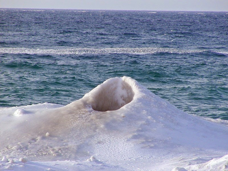
During the winter months, when the Great Lakes in North America freezes over, a unique feature called “ice volcanoes” start forming along the edge of the frozen lakes. As winter ice begins to build along the shores of large lakes, strong winds blowing onshore and wave motion on the waters break up the ice, and they start piling on top of each and building what is known as an ice shelf. Amongst the numerous ice blocks comprising a shelf, many develops cracks.

Waves coming into shore from deeper water strike the edge of the ice shelf, causing them to go under the ice and as the water depth becomes shallow, the energy in the wave causes it to rise up, just like a tsunami. When the energetic wave finds a crack on the ice sheet, it causes the water to sprout creating an ice volcano. If the hole is covered with snow, the eruption may spray snow outward like a volcanic gas cloud.


A more appropriate name for these sprouting water holes would have been “blowholes”, but ice volcanoes actually grow just like their geological cousins. As the ejected water falls back onto the ice, it quickly freezes and begins to form an ice cone, a process very similar to the building of a lava cone surrounding a geologic volcanic vent. The ice cones range in size from 3 feet to more than 30 feet high, and spew a mixture of icy cold water and chunks of ice itself.

Not all ice sheets develop ice volcanoes. To build a good ice volcano cone, a unique set of conditions are required - the surface air temperature must be several degrees below freezing and lake waves several feet high and breaking onshore, which is probably why they are seen at very few places such as on the shores of Lake Michigan, Lake Erie and Lake Superior.


Source:
READ MORE»

Grand Canal of China

The Grand Canal is a series of waterways in eastern and northern China starting at Beijing and ending at the city of Hangzhou in Zhejiang province, linking the Yellow River with the Yangtze River. Stretching some 1,800 km, it is the world’s longest man-made waterway, and constitutes one of the world’s largest and most extensive civil engineering project prior to the Industrial Revolution. At its peak, it consisted of more than 2,000 km of artificial waterways, linking five of China’s main river basins. The canal was built to enable the transport of surplus grain from the agriculturally rich Yangtze and Huai river valleys to feed the capital cities and large standing armies in northern China. Since then, it has played an important role in ensuring commerce and cultural exchange between the northern and southern regions of eastern China and is still in use today as a major means of communication.


The canal was built in sections in different areas in different periods, starting from 5th century BC, but it wasn’t until the 7th-century when a major expansion was carried out, under the direction of Emperor Yang of the Sui dynasty, bringing the canal to the magnitude it’s known for today. Emperor Yang needed a way to move rice from the fertile region around the Yangtze northwest to feed his capital and his armies which were constantly battling nomadic tribes. More than 3 million peasants were pressed into service, supervised by thousands of soldiers. The project took six years to complete, but by that time, approximately half of the peasant workers were dead of hard labour and hunger. But for all the sufferings, the canal proved indispensable for the movement of food supplies. By the year 735, nearly 150 million kilograms of grain were shipped annually along the canal. Other goods, from cotton to porcelain, were also traded, helping China’s economy bloom.

When the Mongol Yuan dynasty (1271–1368) moved the capital of China to Beijing, it eliminated the need for the canal arm to reach west to Kaifeng or Luoyang. A shortcut was made over Shandong province which shortened the length of the Grand Canal by as much as 700 km, and set the present route of the Canal.


In the middle of the Ming dynasty (1368-1644) the canal was overhauled, and a series of fifteen locks was engineered in western Shandong. By this time the imperial transport army had grown to 15,000 boats and employed 160,000 soldiers who supplied the manpower to pull loaded barges when necessary. The successive improvements to the canal allowed the rulers to more easily conduct tours of inspection of their holdings to the south, enabling a greater control of their realm.

Construction of the canal led to many extraordinary engineering innovations. In 587, the world’s first lock gates were invented by the Sui Dynasty engineer Liang Rui for one of the canal’s original sections along the Yellow River; in 984, a transport commissioner named Qiao Weiyo invented the Grand Canal’s first pound lock – the lock that we see in modern canals even today.

When railway became available, the canal gradually fell into disuse and disrepair. Today, only the section from Hangzhou to Jining is navigable. The central and southern sections are maintained and used mainly to transport coal from the mines in the Shandong and Jiangsu provinces. Other sections of the Grand Canal have suffered from a build-up of mud and the northernmost section has all but dried up.


Source
READ MORE»

The Palace and Tomb of King Herod

Located 12 km south of Jerusalem, in the Judean desert, Herodium looks like an extinct volcano, but it really is a fort built by King Herod the Great between 23 and 15 BC. King Herod’s palace and fortress was built atop a natural hill, raised to a greater height by heaping earth around the walls, creating a cone-shaped mountain. The complex was surrounded by double walls seven stories high, within which Herod built a palace that included halls, courtyards and opulent bathhouses. At the base of the fortress was an impressive royal compound with magnificent gardens. A special aqueduct brought water to the desert from the area of Solomon’s Pools near Bethlehem. Being the highest peak in the Judean desert, Herodium commanded a breath taking view, overlooking the desert with the mountains of Moab to the east, and the Judean Hills to the west.


According to the Roman Jewish historian Josephus, Herodium was built on the spot where Herod won a victory over his Hasmonean and Parthian enemies in 40 BC. To commemorate the event, the king built a fortress and a palace there, which he named after himself. He also built, in the plain below the hill, an administrative center for the region. The importance of Herodium to the king is clear from the fact that it is the only monument he constructed to which he gave his name. Since the site had little strategic value to warrant the construction of a fort, it’s believed that Herodium’s sole purpose was to provide a place for the king to live out his last years.

After Herod’s death in 4 BC, Herodium became part of the kingdom of his son Archelaus, who ruled for about 10 years. The Roman procurators then held the place until the outbreak of the Great Revolt in 66 AD. During this revolt, rebels entrenched themselves at Herodium until the Romans defeated them in 71 AD. The fortified mountain palace served as an important center for the rebels during the Bar Kokhba Revolt in the 2nd century. As part of their defense measures, the rebels dug secret tunnels around the cisterns, and hid there. These tunnels can still be explored today.

The site remained deserted until the 5th, when a large community of monks took residence in the area and constructed four churches at the base of the hill. The settlement at Lower Herodium continued to exist until the 8th century, after which Herodium lay abandoned. It was only in the 1970s, that archaeologists began exploring the site. As the excavation progressed, extensive restoration was carried out on the structures of Herodium. Today it is possible to walk on a comfortable path to the top of the fortress, to climb its walls and to enjoy, as in the past, the view of the surrounding region.


Source
READ MORE»

Moulins - Sinkholes on Glaciers

Just like rainwater dissolves the bedrock on the Earth’s crust and form sinkholes, meltwater on a glacier’s surface can melt ice and form sinkholes too. Sinkholes on glaciers are called moulins, French for “mill”. Moulins form when summer meltwater streams on the surface of the glacier finds a crevasse or other weak spot in the ice and begins to pour down through the ice. As the water moves downward, its turbulence and heat creates a narrow, tubular and vertical shaft, up to 10 meters wide, that can go all the way down to the bottom of the glacier, hundreds of meters deep. Water entering a moulin eventually exits the glacier at base level where it acts like a lubricating fluid, that plays a big role on how fast the glacier flows. The melting water accelerates the glacier’s flow to the sea, where large chunks break off to form icebergs, leading to further ice loss by speeding disintegration of the ice sheet.


A hiker stands next to a massive moulin on Snowbird Glacier.

Given enough water flow, a moulin can easily form over the course of just a month. Once formed, the shaft will stay open as long as there is meltwater to feed the moulin. If the meltwater freezes, the moulin will begin to fill up with snow and close up. Some moulins have been observed to be present in the same spot for multiple years, though the spot will constantly move forward with the flow of the ice.


Schematic drawing of glacial features illustrating how moulins transport surface water to the base of the glacier.


A moulin cuts through Bering Glacier.


Meltwater pouring into a moulin on Greenland.


A hiker descends inside a moulin, Greenland.


An explorer scaling a moulin on Mer de Glace glacier in Chamonix, France.


An explorer scaling a moulin on Mer de Glace glacier in Chamonix, France.


A moulin on Mendenhall Glacier.


A moulin on Mendenhall Glacier.


A moulin filled with water on Columbia Glacier.


Surface water entering a moulin on Athabasca Glacier.


A moulin on Malaspina Glacier.


Source
READ MORE»

The Thirteen Towers of Chankillo

Located in the Peruvian coastal desert at the Casma-Sechin Oasis, stands the incredible monumental complex of Chankillo, also known as Chanquillo, which extends across four square kilometers. The ancient archaeological site consists of a fort located on hilltop and thirteen solar observatory towers, as well as residential and gathering areas. It was occupied for a relatively short period of time – between the mid-fourth century BC and the early first century AD.


Located between two observation platforms, the thirteen astronomical towers span the entire annual rising and setting arcs of the sun, which shift north and south along the horizon gradually over the course of a year. What makes Chankillo so important is the fact that, according to archaeologists, Chankillo may be the earliest known astronomical observatory in the Americas, built some 2,300 years ago. The Incas, also well known astronomers, observed the sun and the stars, but they did so many centuries later.


Remains of Chankillo Fortaleza. Archaeological site near Casma, Ancash in Peru

Research has shown that the astronomical alignments seen at Chankillo were, and still are, incredibly precise. The towers have been known about for a long time but their astronomical value had not been widely realized until Ivan Ghezzi and Clive Ruggles undertook detailed research at the site in 2007. Archaeologists suggest that the inhabitants of Chankillo would have been able to determine the date with an accuracy of +/- two to three days by observing the sunrise/sunset from the correct observational platform. On the winter solstice, the sun would rise behind the further tower on the left and then over time, would rise behind each of the towers until it reached the furthest tower on the right some six months later on the summer solstice, marking the passage of time. Other ancient sites known for astronomical observatories contain only one point of astronomical alignment which does not provide enough information for an accurate measurement of time over one year.


One of the towers at Chankillo, Peru.

The towers at Chankillo, which are spaced at intervals between 4.7 and 5.1 meters, vary in shape and size, ranging from 70 to 130 meters in width and up to 6 meters in height. According to archaeologists, at the time the towers were constructed they were completely flat on top. [To view the thirteen towers of Chankillo on Google Maps, select Google Earth’s ‘Fly To’ option and enter latitude: 9 33 40.27 S and longitude: 78 13 38.53 W.]

The walls of this ancient site were once shiny white, with paintings and figures decorating the monuments. The structures found at Chankillo were built of shaped stone and mortared walls, a combination that reflects the surroundings of this coastal desert and incredibly beautiful environment in Peru. Apart from observing the Sun, the Chankillo observatory would have aided the builders of Chankillo to know the best time to plant and harvest of crops.


Chankillo, Peru.

The most puzzling aspect of Chankillo is, who built this incredible complex? Archaeologists no almost nothing about these ancient builders who paid tribute to the sun and stars, constructing the first ever solar observatory in the Americas.

Like many other ancient cultures that have worshiped the sun and the Sun God, Chankillo wasn't much different, as the towers were probably built, not only as a calendar and observatory, but also as a place with which to celebrate their mystical connection with the sun. "If you were just measuring seasons, there would be no need to make such great structures," says Ghezzi. "The idea was to transmit a political and ideological message about a ruler's close relationship with the sun."


Source
READ MORE»

Heavy Lift Ships

When you need to transport large cargo, goods, and materials from one place to another, ship is the ideal choice even though they are extremely slow. Thousands of cargo carriers ply the world's seas and oceans each year, and they handle the bulk of international trade. Then there are heavy lift ships that are designed to carry excessively large loads that even cargo ships cannot bear, such as other ships, drilling rigs or anything else too large or heavy to be easily transported on a conventional ship.

Heavy lift ships are of two types: semi-submerging capable of lifting another ship out of the water and transporting it; and vessels that augment unloading facilities at inadequately equipped ports. Semi-submerging are more commonly known as a "flo/flo" for float-on/float-off. These vessels have a long and low well deck that can go down under water allowing oil platforms, other vessels, or other floating cargo to be moved into position for loading. The tanks are then pumped out, and the well deck rises higher in the water, lifting its cargo, and is ready to sail wherever in the world the cargo needs to be transported.


The world's first heavy lift vessel was MV Lichtenfels (118 long tons; 132 short tons) constructed in the 1920s by the Bremen based shipping company DDG Hansa. After World War II, DDG Hansa became the world's largest heavy lift shipping company. Today that title is owned by Dockwise which currently operates 19 heavy lift ships – the world’s largest fleet of semi-submersible vessels of various sizes and types.

The flo/flo industry's largest customer base is the oil industry. They have transported many oil drilling rigs from their construction site to the drilling site at roughly three to four times the speed of a self-deploying rig.

In 1988, the heavy lift ship Mighty Servant 2 towed the guided missile frigate USS Samuel B. Roberts, which was nearly sunk by a naval mine in the central Persian Gulf. Eleven years later, MV Blue Marlin transported the U.S. guided missile destroyer USS Cole from Aden, Yemen to Pascagoula, Mississippi, after the warship was damaged in a bombing attack on 12 October 2000.

In 2004, Blue Marlin carried the world's largest semi-submersible oil platform, 60,000 tonne semi-submersible production rig, Thunder Horse, over 15,000 nautical miles from Okpo, Korea to Corpus Christi, Texas.

Many of the larger ships of this class are owned by the company Dockwise, including Mighty Servant 1, MV Blue Marlin, and MV Black Marlin. The company is currently building another heavy weight named the Vanguard that will have 50% greater lifting capacity and 70% greater deck area than the largest heavy lift ship now in service, the Blue Marlin. At 275 meters (902 feet) long and 70 meters (230 feet) wide, the Vanguard can lift 110,000 tonnes and travel across oceans at 14 knots.


Dockwise Swan loading a smaller ship on the deck

Dockwise Tern in the process of loading an oil platform


Dockwise Black Marlin with an oil plaform


MV Blue Marlin goes underwater to prepare for loading.


MV Blue Marlin carrying USS Cole after the warship was damaged in a bombing attack


MV Blue Marlin with an oil platform on its deck


The coastal mine-hunters USS Cardinal (MHC-60) and USS Raven (MHC-61) sit on the deck of MV Blue Marlin after de-ballasting operations, which lifted the mine-hunters onto the MV Blue Marlin’s deck for transport.


The heavy lift vessel MV Blue Marlin with its deck cargo of the Sea-Based X-Band Radar enters Pearl Harbor, Hawaii, after completing a 15,000-mile journey from Corpus Christi, Texas, on January 9, 2006.


MV Mighty Servant 2 carries USS Samuel B. Roberts from Dubai to Newport, R.I., in 1988.


Mighty Servant 3 carrying her last cargo


Source
READ MORE»