Lake Urmia, in north-western Iran, was once one of the largest permanent saline lake in the world and the second largest in the Middle East, after the Dead Sea. At its full size, it extended as much as 140 km from north to south and 85 km from east to west, covering an area larger than 5,200 square km. Historically, the lake attracted many species of migratory birds including flamingos, pelicans, ducks and egrets. The lake itself is home to a unique brine shrimp species, Artemia urmiana, and along with the surrounding wetlands and upland habitat, it supports many species of reptiles, amphibians and mammals. The watershed of the lake is an important agricultural region with 6.4 million people depending on it.
But for the last two decades, the lake has been shrinking drastically. It’s southern end has almost dried up reducing the surface area to 2,000 square km and its water volume has shrunk nearly 95 per cent. Diversion of water for irrigation process and prolonged drought are said to be the causes.

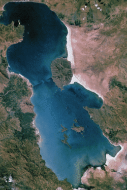
Satellite picture of Lake Urmia, taken on June 23, 2014
Lake Urmia is an endorheic or terminal lake meaning that the lake has no outflow, and the only way water leaves the lake is by evaporation. As many as thirteen rivers dump their waters into the lake, with the largest being Zarrineh Rood River which accounts for the majority of the Lake’s water budget. Additional input comes from rainfall directly over the lake, floodwater and a very small fraction from groundwater flow.
The most significant cause of Lake Urmia's decline is the diversion of water from its rivers. Other contributing causes being reduced rainfall, warmer temperatures and groundwater abstraction. The number of wells pumping groundwater increased from a few thousand in 1973 to over 70,000 in 2005.
Satellite imagery from 1984 to 2014 revealing Lake Urmia's diminishing surface area.
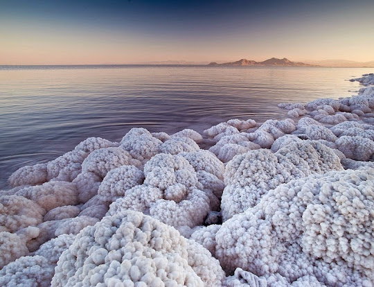
The drying up of Lake Urmia has significantly affected the lake’s shrimp population. Because the lake has no outlet, Lake Urmia is very saline and the loss of water has increased the lake’s salinity to the point that it’s now threatening the survival of the shrimps. The lake's brine shrimp are responsible for the production of the lake's algae and the diverse migratory bird population which feeds on these shrimp. The loss of the brine shrimp would translate into the loss of many of Lake Urmia's migratory bird populations and affect the entire ecosystem's sustainability.
One can draw a parallel between the fate of Lake Urmia and the tragic demise Aral Sea in western Uzbekistan. Once one of the world’s largest lakes, the Aral Sea faded away due to diversion of water for agriculture from the two rivers that fed the lake. Over the course of five decades its surface area dropped to less than 10% of its original extent in the 1960s.
The drying up of Lake Urmia, however, underlies a broader water problem. In recent years, several large Iranian rivers have dried up, and so has Iran's third-largest lake, Hamoun, in the southeast.
New Scientist reported last year that the Iranian government had earmarked half a billion dollars in a bid to restore the once-enormous lake by proper water management, reducing farmers' water use, and restoring the local environment.
Source
READ MORE»
But for the last two decades, the lake has been shrinking drastically. It’s southern end has almost dried up reducing the surface area to 2,000 square km and its water volume has shrunk nearly 95 per cent. Diversion of water for irrigation process and prolonged drought are said to be the causes.
Satellite picture of Lake Urmia, taken on June 23, 2014
Lake Urmia is an endorheic or terminal lake meaning that the lake has no outflow, and the only way water leaves the lake is by evaporation. As many as thirteen rivers dump their waters into the lake, with the largest being Zarrineh Rood River which accounts for the majority of the Lake’s water budget. Additional input comes from rainfall directly over the lake, floodwater and a very small fraction from groundwater flow.
The most significant cause of Lake Urmia's decline is the diversion of water from its rivers. Other contributing causes being reduced rainfall, warmer temperatures and groundwater abstraction. The number of wells pumping groundwater increased from a few thousand in 1973 to over 70,000 in 2005.
Satellite imagery from 1984 to 2014 revealing Lake Urmia's diminishing surface area.
The drying up of Lake Urmia has significantly affected the lake’s shrimp population. Because the lake has no outlet, Lake Urmia is very saline and the loss of water has increased the lake’s salinity to the point that it’s now threatening the survival of the shrimps. The lake's brine shrimp are responsible for the production of the lake's algae and the diverse migratory bird population which feeds on these shrimp. The loss of the brine shrimp would translate into the loss of many of Lake Urmia's migratory bird populations and affect the entire ecosystem's sustainability.
One can draw a parallel between the fate of Lake Urmia and the tragic demise Aral Sea in western Uzbekistan. Once one of the world’s largest lakes, the Aral Sea faded away due to diversion of water for agriculture from the two rivers that fed the lake. Over the course of five decades its surface area dropped to less than 10% of its original extent in the 1960s.
The drying up of Lake Urmia, however, underlies a broader water problem. In recent years, several large Iranian rivers have dried up, and so has Iran's third-largest lake, Hamoun, in the southeast.
New Scientist reported last year that the Iranian government had earmarked half a billion dollars in a bid to restore the once-enormous lake by proper water management, reducing farmers' water use, and restoring the local environment.
Source