Asbyrgi Canyon Iceland

Located in the north of Iceland, at a distance of about 65 km from the harbor town of Husavik, within Vatnajökull National Park, lies an enormous horseshoe shaped depression called the Asbyrgi Canyon. The canyon is 3.5 km long and 1 km wide, and its steep sides are formed by cliffs up to 100 metres in height. The canyon floor is heavily forested with trees such as birch, willow, fir, larch, and pine, but during summer it’s possible to take the road that leads through the thick forest and all the way to the foot of the cliff where there is small lake called Botnstjorn, where you will find a variety of waterfowl species. The well vegetated area between the canyon walls is a very popular recreational area, especially among families, and local festivals are celebrated there. The canyon is divided in the middle by a 250 meters wide raised island called Eyjan, from which hikers can enjoy spectacular views across the land.


According to Norse mythology, Ásbyrgi was formed when Odin's eight-legged horse, Sleipnir, touched one of its feet to the ground here. Thus, the canyon is also known as ‘Sleipnir’s footprint’. However, geologist believe that Asbyrgi was most formed by two catastrophic glacial flooding of the river Jökulsá á Fjöllum after the last Ice Age. The first one occurred when the ice melted some 10,000 years ago, and then another occurred some 3,000 years ago when the Hekla volcano erupted underneath the Vatnajökull ice cap and melted the ice. The river has since changed its course and now runs about 2 km to the east.


Source
READ MORE»

Zona del Silencio

Deep in the desert in northern Mexico, between the states of Durango, Chihuahua and Coahuila, is an area known as zona del silencio or the "zone of silence", also known as Mapimí Silent Zone for its close proximity to the city of Mapimi. Legend says that in this area electromagnetic transmissions cannot be received, radio doesn’t work, compasses do not point to magnetic north, and the flora and fauna have abnormal mutations. Over the years stories of alien encounters, falling "hot pebbles" and all sorts of paranormal activities have been drawing tourists and curiosity-seekers from all over the world.

The myth started in July, 1970, when the U.S. military base near Green River, Utah fired an Athena test missile toward White Sands Missile Range. The missile lost control and instead of landing on the intended target continued 400 miles south and fell in the Mapimí Desert region. Immediately, a team of specialists arrived to find the fallen rocket. When the rocket was found after three weeks of intense search, an airstrip was built to transport the wreckage. The entire operation was very hush-hush, consistent with governmental common sense, and nobody was told anything or asked. The secretive nature of the operation was already spurring rumors among the residents.


One version of the story tells about a certain local named Jamie who was hired by the military to guard the missile from vandals and sight-seers. Jaime rather liked the attention and money that the missile had brought, and when the military left, he along with two local landowners began to talk of the possibility of building a hotel in the area to encourage tourism. Some say that it was Jamie who began playing up the importance of the region to generate interest in the area, and together with his new friends started creating a story with lots of pseudo-science and local folklore, and fed it to the regional media. The media swallowed it hook, line and sinker, and a legend was born.

According to this bizarre story, strange magnetic anomalies of the atmosphere prevent radio transmission in specific points and make the needles spin on magnetic compasses. The magnetic waves are so unique that they create a vortex that draws in material from the upper atmosphere, including the ill-fated missile. The Allende meteorite, which fell in the general region of the Zone in 1969, is often cited as corroborating evidence.

The phenomena is now claimed to have been first reported in the 1930s by Francisco Sarabia, a Mexican pilot, who claimed that his radio had mysteriously failed to function while flying over the zone. Others claim to have seen UFOs, and objects falling from cloudless skies.


Now hundreds of people come from all over to experience the area. The locals call them zoneros. They are surprised when they find their radios and compasses working, upon which their guide – often a local, for whom these tourists represent a source of income, explains to them that the zones move, and therefore be hard to locate.

The local residents themselves do not believe in the Zone of Silence. When asked about strange phenomena, they invariably reply that they do not see strange things in the desert, only strange people. While some are eking out a living becoming guides or selling sodas and eatables to tourists, others find these outsiders a nuisance.

Mexconnect.com shares an amusing anecdote:

Upon being asked where la Zona could be found, a local rancher told a carload of people that they needed to keep following the road until they saw martians jump from one side of the road to another. The amazing part, he commented later, was that they thanked him. Another group of zoneros arrived at the field station and asked one of the workers how to get to the Zone. The young fellow, struggling to be polite and truthful at once, only replied, "Nunca van a llegar (You are never going to get there)."


Source
READ MORE»

Ancient Earthen Castles of China

Fujian Tulou is a collection of earthen houses, impenetrable by outsiders, built between the 12th and the 20th centuries, located in the mountainous areas in southeastern Fujian, China. A tulou is usually large, several storeys high, and built along an inward-looking, circular or square floor plan. The doughnut shaped house has a central open courtyard and can house up to 800 people or 80 families each. The outside wall is a solid block served by only one entrance, and windows to the outside are located only above the first floor. Tulous were built for defense against armed bandits that plagued southern China from the 12th century to 19th century. The people of southern Fujian first built strongholds on top of mountains as a defense. These early strongholds later evolved into Fujian Tulou.


The fortified outer structures are formed by compacting earth, mixed with stone, granite, bamboo, wood and other readily available materials, to form walls up to 6 feet thick. Branches, strips of wood and bamboo chips are often laid in the wall as additional reinforcement. The entrance is guarded by 4-5 inch thick wooden doors reinforced with an outer shell of iron plate. The top level of these earth building have gun holes.

The tulous are as solid as a castle and offered specular resistance against cannon fire. In 1934, a group of uprising peasants of Yongding County occupied a tulou to resist the assault of the army, which fired 19 cannon shots at that tulou, but made only a small dent on the outside wall.

Housing a whole clan, the whole structure functioned as small village and were known as “a little kingdom for the family” or “bustling small city.” The buildings were divided vertically between families with each disposing of two or three rooms on each floor. In contrast with their plain exterior, the inside of the tulou were built for comfort that is warm in winter and cool in summer, and were often highly decorated. The rooms are well-lit, well-ventilated, windproof, and the entire building earthquake-proof.

There are more than 20,000 tulous in Fujian, scattered in the mountainous southeastern region of Fujian province. Although tulous are found in other parts of China, they are all referred to as Fujian Tulou after UNESCO adopted that name for all dwellings of this type. A total of 46 Fujian Tulou sites have been inscribed in 2008 by UNESCO as World Heritage Site, as "exceptional examples of a building tradition and function exemplifying a particular type of communal living and defensive organization in a harmonious relationship with their environment".


Source
READ MORE»

Dissappearing Glaciers in 100 Years

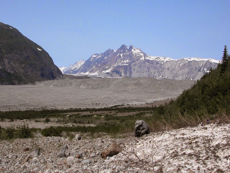
We are currently living in an interglacial period, a relatively warm period of time during an ice age, which will last several thousands of years until the next glacial period starts. The current interglacial period, which began between 10,000 and 15,000 years ago, caused the ice sheets from the last glacial period to begin to melt and disappear away, and the process is still happening. However, the melting has been accelerated since the 1850s, largely as a consequence of human activities.

These historical photographs of glaciers, when compared with photos taken at a more recent date, shows the dramatic change in the landscape and vegetaition that resulted when the glaciers retreated. The photos were taken at various locations in Alaska, including Glacier Bay National Park and Preserve, Kenai Fjords National Park, and the north-western Prince William Sound area of the Chugach National Forest.


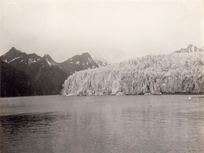
Muir Glacier and Inlet


A photograph taken on the west shoreline of Muir Inlet, Glacier Bay National Park and Preserve, Alaska on September 2, 1892 shows the more than 100-meter (328-feet) high, more than 4 kilometers (2.5 miles) wide tidewater terminus of the glacier. Some icebergs, evidence of recent calving, can be seen floating in Muir Inlet.


This photograph taken from the same location on August 11, 2005. Muir Glacier is no longer visible, as it has retreated more than 50 kilometers (31 miles). During the interval between photographs, Muir Glacier ceased to have a tidewater terminus. Note the lack of floating ice and the abundant vegetation on many slopes throughout the photograph.


A photographs taken on the east shoreline of Muir Inlet, Glacier Bay National Park and Preserve, between 1880s – 1890s shows the more than 100-meters (328-feet) -high tidewater terminus of the glacier. Numerous icebergs, some more than 2 meters (6.6 feet) in diameter are grounded on the tidal flat in the foreground.


On this photograph taken from the same location on August 11, 2005, Muir Glacier has retreated more than 50 kilometers (31 miles) and is completely out of the field of view. The beach in the foreground is covered by a cobble and pebble lag deposit, which was winnowed from sediment that was deposited by Muir Glacier and by melting grounded icebergs.


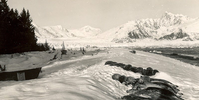
Photograph taken on August 13, 1941, shows the lower reaches of Muir Glacier, then a large, tidewater calving valley glacier and its tributary Riggs Glacier. The ice thickness in the center of the photographs is more than 0.7 kilometers.


Photograph taken from the same location on August 31, 2004. Muir Glacier has retreated out of the field of view and is now located more than 7 kilometers (4.4 miles) to the northwest. Riggs Glacier has retreated as much as 0.6 kilometers (0.37 miles) and thinned by more than 0.25 kilometers.


Reid Glacier

A photograph of Reid Inlet, Glacier Bay National Park and Preserve, taken on June 10, 1899, shows the approximately 60-meter (197-foot)-high tidewater terminus of the then retreating Reid Glacier.


Photograph taken on September 6, 2003, from the same location. Reid Glacier has retreated about 3 kilometers (1.9 miles) and is just visible at the head of the fiord on the left side of the field of view. The hillside in the foreground is covered with dense vegetation, including both conifers and deciduous trees.


Carroll Glacier

A photograph taken on August 1906 shows the calving terminus of Carroll Glacier sitting at the head of Queen Inlet.


This photograph taken on June 21, 2004, shows that the terminus of Carroll Glacier has changed to a stagnant, debris-covered glacier that has significantly thinned and retreated from its 1906 position. The head of Queen Inlet has been filled by sediment.


Pedersen Glacier

A photograph of Pedersen Glacier on July 23, 1909 the north side of the then retreating terminus of Pedersen Glacier, grounded on the beach above tidewater. Little, if any vegetation is present in the photograph


This photograph taken on August 13, 2004 documents the retreat of Pedersen Glacier from the field of view, a retreat of about 1.5 kilometers (0.93 miles). Diverse vegetation, featuring alder and spruce, has become established on the hill slopes and on the elevated ground of the former terminus.


Another view of the Pedersen Glacier from the mid-1920s and the early 1940s.


The second photograph dates from August 10, 2005. In the roughly 60 - 80 years between photographs, most of the lake/lagoon has filed with sediment and now supports several varieties of grasses, shrubs, and aquatic plants. Pedersen Glacier’s terminus has retreated more than 2 kilometers (1.24 miles). The tributary located high above Pedersen Glacier separated from it sometime during the third quarter of the 20th century. No icebergs are visible. Isolated patches of snow are present at a few higher elevation locations.


McCarty Glacier

A photograph taken from the mouth of McCarty Fjord, on July 30, 1909, shows the west side of the terminus of the then retreating McCarty Glacier. Little, if any vegetation is present in the photograph


This photograph was taken from the same location on August 11, 2004. It shows the retreat of McCarty Glacier from the field of view, a retreat of more than 15 kilometers (9.8 miles). Dense, diverse vegetation, featuring spruce, has become established on the hill slopes.


Northwestern Glacier

This photograph of Harris Bay, Kenai Fjords National Park, was taken between the mid-1920s and the 1940s. Shallow water adjacent to the shoreline in the foreground appears to be covered by a small thickness of sea ice, containing a number of pieces of brash ice. Northwestern Glacier spans most of the width of the photograph.


The second photograph dates from August 12, 2005. In the roughly 60 - 80 years between photographs, Northwestern Glacier has retreated out of the field of view. Sedimentation and uplift have expanded the shore area and produced a marshy wetland covered by a diverse array of vegetation.


Lamplugh Glacier

This photograph of Lamplugh Glacier was taken on August 1941. It shows the calving terminus of Lamplugh Glacier extending to within (0.8 kilometers) 0.5 miles of the photo point.


This photograph was taken on September 8, 2003. It shows that the terminus of Lamplugh Glacier has actually progressed to more than 0.5 kilometers (0.3 miles) forward of its 1941 position. Additionally, glacial sediment on the bedrock ridge in the foreground indicates that Lamplugh Glacier had advanced beyond the photo point at some time during the interval between photographs, probably in the late -1960s.


Source
READ MORE»