Bialbero de Casorzo - The Double Tree in Italy

Between Grana and Casorzo in Piemonte, Italy, a very unique tree grows. Known as the “double tree of Casorzo” or Bialbero de Casorzo in Italian, it is a mulberry tree on top of which a cherry tree grows. The cherry tree rises well above the mulberry tree on which it stands. The strange tree is also known as Grana Double Tree.

Nobody knows for sure how this happened; probably some bird dropped a seed on top of the mulberry which then grew roots through the hollow trunk of the host tree to reach the soil. While trees growing parasitically over another tree is not unusual, but they normally do not reach the size and lifespan as seen in this particular example, as there is not enough humus and space available where they grow. Large “double-trees”, also called Epiphytes, like the Bialbero de Casorzo are a rarity.


Source
READ MORE»

The Sedan Nuclear Crater

The Sedan nuclear crater is located at the Nevada Test Site, about 90 miles north of Las Vegas. It is the result of the Sedan nuclear test, an underground nuclear test carried out on 6 July 1962 as part of the Plowshare Program, established in June 1957 to explore peaceful applications for controlled nuclear detonations. The idea was that a nuclear explosion could easily excavate a large area, facilitating the building of canals and roads, improving mining techniques, or simply moving a large amount of rock and soil. The intensity and distribution of radiation, however, proved too great, and the program was abandoned. Operation Plowshare resulted in 27 thermonuclear detonations. Only four events were intended to produce craters, among which Sedan was by far the largest.


The device that produced the crater was buried 194 meters below the desert floor and had a yield equivalent to 104 kilotons of TNT or around eight Hiroshima bombs. The blast first lifted a dome of earth 90 meters above the desert floor before it vented at three seconds after detonation, exploding upward and outward displacing 12 million tons of earth. The resulting crater is 100 meters deep and 390 meters wide.

The explosion created fallout that affected more US residents than any other nuclear test, exposing more than 13 million people to radiation, although within 7 months of the detonation, the radiation had decayed to the point that the bottom of the crater could be safely walked upon with no protective clothing. Today, more than 10,000 visitors visit the crater every year through free monthly tours offered by the U.S. Department of Energy. An observation platform built on the rim of the crater allows tourists to peek into the crater below.

Negative impacts from Operation Plowshare’s 27 nuclear projects ultimately led to the program's termination in 1977, largely due to public opposition.

The Soviet Union continued to pursue the concept through their program “Nuclear Explosions for the National Economy” and carried out more than 150 nuclear test. The best known was Chagan – a test identical to Sedan - which created the artificial lake reservoir Lake Chagan.


The Sedan nuclear test on 6 July 1962.


Satellite image of the Sedan crater.


The Nevada Test Site is pockmarked by numerous nuclear tests. The Sedan crater is the largest among them.


Observation deck at Sedan Crater.


Source
READ MORE»

The Atomic Lake Filled With Radioactive Water

During the hey days of Cold War, the Soviet started blowing up nukes all over northeastern Kazakhstan to investigate the possibility of using nuclear power for peaceful construction purposes such as moving earth, creating canals and reservoirs, drilling for oil and so on. The tests were carried out under the banner of “Nuclear Explosions for the National Economy”. This was the Soviet version of “Operation Plowshare” – a similar program devised by the U.S.

Having borrowed the terrible idea from the U.S., the Soviet program got underway in vigor and ended up being many times larger than the U.S. Plowshare program both in terms of the number of applications explored with field experiments and the extent to which they were introduced into industrial use. While the U.S. conducted 27 tests before realizing it was a bad idea and terminated the program in 1977, the Soviets continued right up to 1989 during which as many as 156 nuclear tests were conducted.


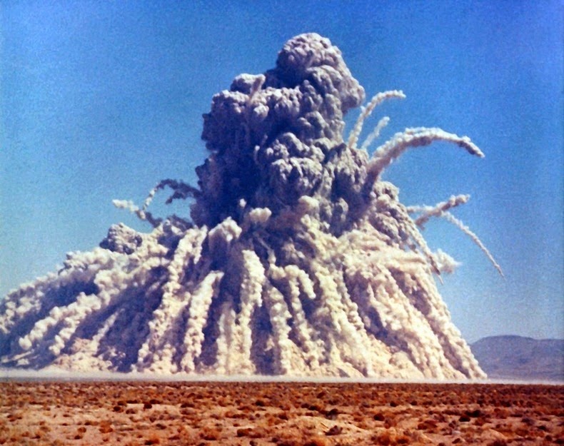
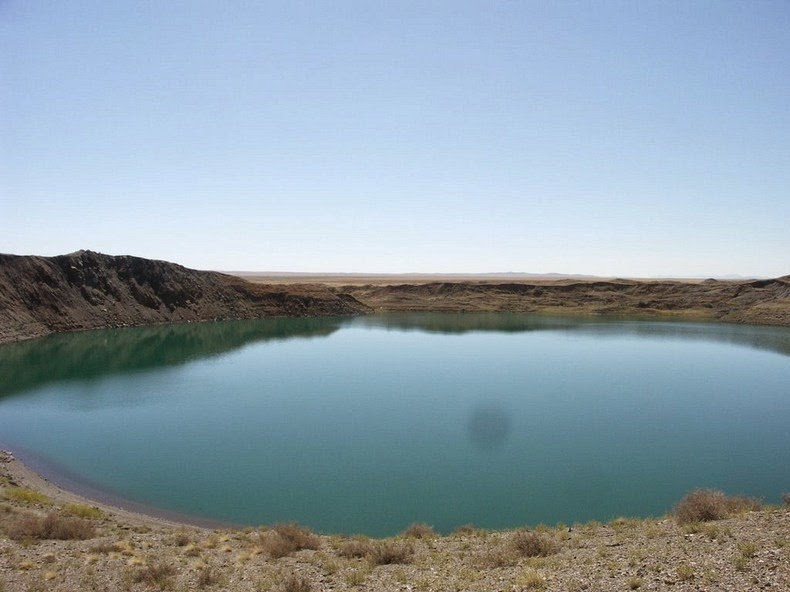
One of the better known tests is the January 1965 test at Chagan, on the edge of the Semipalatinsk Test Site in Kazakhstan. The Chagan test was designed to test the suitability of nuclear explosions for creating reservoirs. It was the first and largest of all detonations carried in the Nuclear Explosions for the National Economy program. A 140 kiloton device was placed in a 178 meter deep hole in the dry bed of the Chagan River so that the crater lip would dam up the river during periods of high flow. The blast created a crater 400 meters across and 100 meters deep with a lip height of 20 to 38 meters. Later, a channel was cut into the crater allowing it, and the reservoir behind it, to fill up with water.

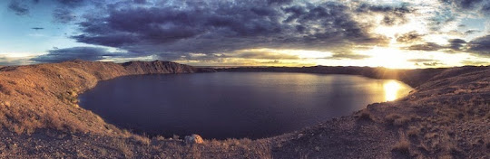
The reservoir, known informally as Lake Chagan, still exist today in substantially the same form. The water continues to be radioactive - about 100 times more than the permitted level of radionuclides in drinking water, though 100-150 meters away dose levels were at background level. At that time of its creation, the Soviet government was proud of Lake Chagan. They made a film with the Minister of the Medium Machine Building Ministry, the one responsible for the entire Soviet nuclear weapons program, taking a swim in the crater lake and water from it was used to feed cattle in the area.

It was estimated that some 20% of the radioactive products from the Chagan test escaped the blast zone, and were detected over Japan. This infuriated the USA for violating the provisions of the October 1963 Limited Test Ban Treaty, which banned atmospheric tests. The Soviets replied that it was an underground test and the quantity of radioactive debris that escaped into the atmosphere was insignificant. After several subsequent interactions, the matter was eventually abandoned

Also see: Sedan Nuclear Crater in Nevada Test Site, based on which the Chagan test was conducted.

Video of the nuclear test that created Lake Chagan.


Satellite picture of Lake Chagan (the circular crater) and the reservoir (below).


Source
READ MORE»

Monastery in Wadi Qelt

Wadi Qelt is a rocky canyon located in the Judaean Desert in the West Bank, originating near Jerusalem and terminating near Jericho, near the Dead Sea. In this isolated and barren valley a 4th-century monastery clings precariously to the rock walls. Originally built around a cave, the monastery grew in the 5th century under Greek Orthodox when its most famous monk and namesake Gorgias of Koziba inhabited the place.

St. George's Monastery began in the 4th century when a few monks seeking the desert experiences of the prophets settled around a cave where they believed Elijah was fed by ravens. The Greek Orthodox monastery was built in the late 5th century A.D. by John of Thebes, who became a hermit and moved from Egypt to Syria Palaestina in 480 A.D. The monastery was named St. George after the most famous monk who lived at the site – Gorgias of Koziba.


The monastery was destroyed in the year 614 by the Persians who swept through the valley and massacred the fourteen monks who dwelt there. The bones and skulls of the martyred monks can still be seen today in the monastery chapel. After the Persian invasion, the monastery lay abandoned for nearly 500 years until restoration attempts were made by bands of Crusaders in the 12th century. But after they were expelled, the monastery fell back into disuse. In 1878, a Greek monk, Kalinikos, settled here and restored the monastery, finishing it in 1901.

Today, the monastery is unique in its acceptance of female pilgrims and visitors, a precedent set through the tradition of a Byzantine noblewoman on a monastic tour who claimed that the mother of God had directed her there for healing from her incurable illness.

The monastery is located 20 km from Jerusalem along the historic road from Jericho to Jerusalem, which runs parallel to the valley. A pedestrian bridge across the Wadi Qelt connects the monastery to the road.


Source
READ MORE»

Cono de Arita, Argentina

Near the south border of Salar de Arizaro, the sixth largest salt flat on earth and the second largest in Argentina, 70 km from the village of Tolar Grande, lies a strange volcanic pyramid. An almost perfect cone, it rises unexpectedly in the middle of the salt pan. This is Cono de Arita and it looms majestically 122 meters above the Salar. Its name comes from the Aymara language where Arita means “sharp”.

In the early twentieth century it was believed that such a perfect cone could only have been built by man. But Cono de Arita is natural and believed to be a small volcano which lacked strength to burst through the curst and so never threw lava or developed a crater. Everything around the cone is black salt brought to the surface by ancient magma flows underground. According to the archaeological remains found in the cone, the place was a ceremonial center prior to the arrival of the Incas.


Source
READ MORE»