China’s New Highway is Built Over Water

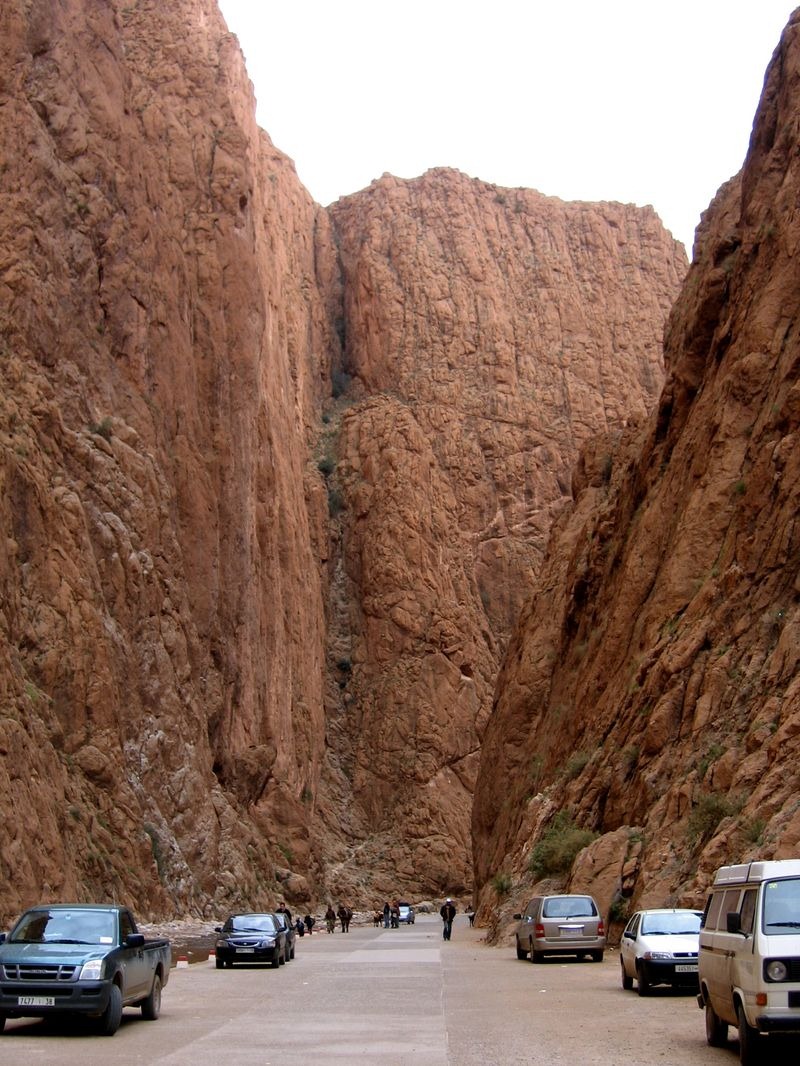
China has opened a new stretch of road that connects Xingshang County to the Zhaojun Bridge in central China’s Hubei province. A 4-km-long section of the 10-km route is built on top of an elevated bridge that runs along the middle of a river valley. The new route will cut down travel time from Xingshan to the Yiba Expressway to just 20 minutes, and at the same time treat drivers to a spectacular scenery. The journey originally took close to an hour along a steep and convoluted road.

According to the project manager of the road Chen Xingda, when the motorway was first proposed in 2013, there were three different possible routes. Two of the routes involved digging a tunnel through the mountains in the area. The third was a longer route and involved building on water. Engineers on the project chose the third option because that would enable them to protect the abundance of plants and woodland in the mountains. Those involved in the project claim this to be China’s first “ecological overwater road”. The overwater highway cost about 2 million yuan (US$320,000) to construct which was nearly half of the 4.4 million yuan ($700,000) it cost to build the entire thing.


Source
READ MORE»

Unique Borders in Baarle-Nassau and Baarle-Hertog

Baarle-Nassau and Baarle-Hertog are two municipalities that divide the town of Baarle on the border between the Netherlands and Belgium. Baarle-Nassau is located in southern Netherlands in the North Brabant province and Baarle-Hertog is located in the Belgian province of Antwerp. Both towns share a common border, but the international border that separates the Belgian town of Baarle-Hertog from the Dutch town of Baarle-Nassau does not run straight. It is not even curved.

Instead, there are 26 separate pieces of land – little bits of Belgium and Netherlands scattered around Baarle. There is a main piece called Zondereigen located north of the Belgian town of Merksplas, and 22 Belgian exclaves in the Netherlands and three more pieces on the Dutch-Belgian border. Within the largest Belgian exclave there are also six Dutch exclaves, one within the second-largest, and an eighth within Zondereigen.


The border is marked with white crosses on the pavement and metal studs in the road, and it zig-zags its way across the town paying no heed to houses, gardens and streets. One line enters a block via a gift shop then comes out of the back of a supermarket. Many homes are cut in half by the border, so as a matter of convention each household's nationality is determined by the location of its front door. If the border runs through the street door, the two parts then belong in different states, and this is indicated by two street numbers on the building.

The towns attract a lot of tourists. For many years the shops in Belgium were open on Sundays, those in the Netherlands not – with the exception of those in Baarle. Taxes in Belgium and The Netherlands differed sometimes a lot, so one could go shopping between two tax-regimes in one single street. There was a time when according to Dutch laws restaurants had to close earlier. For some restaurants on the border it meant that the clients simply had to change their tables to the Belgian side. With the coming of the European Union, however, some of those differences disappeared.

Baarle-Hertog and Baarle-Nassau’s bizarre geography results from a number of equally complex medieval treaties, agreements, land-swaps and sales between the Lords of Breda and the Dukes of Brabant that can be traced back to the 12th century. After the split between the Netherlands and Belgium was finally settled in 1839, there was a need to determine the border. It took three border commissions to sort out the issues. The last one fixed a 36 km stretch and was completed only recently in 1995.


Source
READ MORE»

Todra Gorge in Morocco

In the eastern part of the High Atlas Mountains in Morocco, near the town of Tinerhir, the Todra and the Dades Rivers have carved out a narrow canyon called Todra Gorge (sometimes spelled Todgha Gorge), on their final 40 kilometers through the mountains. The gorge takes its most spectacular form about 15 km from Tinghir. Here, for about 600 meters, the canyon walls closes in to a mere 10 meters from each other, while the sheer and smooth rock walls rise up to 160 meters on each side. It is said that the gigantic rock walls magically change color as the day progresses.

At the bottom of the gorge flows an ice-cold river, which at one point of time, carried great quantities of water which is apparent from the size of the canyon that was carved out of the rocks. The river has since dried up and reduced to a tiny glacier stream. A well-maintained asphalt road leads all the way from Tinerhir to the gorge and beyond it.


The gorge is breathtaking and easy hike by foot with many places to stop and photograph. The robust rock sides with many uneven surfaces provide plenty of opportunities for rock climbing. You can even spend the night here in one of the small hotels and lodges that the locals have set up inside the gorge.


Source
READ MORE»

The Island That Only Appears in Spring

Every year, with the coming of spring, thousands of Chinese tourists flock to the The Gorges Reservoir to see an elusive turtle-shaped island rise from the waters of the Muodaoxi River. The event, dubbed ‘spring turtle rising from water’, is celebrated by local residents because turtles are considered auspicious and a sign of longevity.

It sounds like a fascinating natural phenomenon similar to the Jindo Moses Miracle that takes place in South Korea, but in this case the “magic” is man-made. The water level of Muodaoxi River is controlled by the Three Gorges Dam. In spring, the reservoir supplies water to the areas downstream, bringing down the water level and exposing the island.


The appearance of the island depends on the amount of floodwater heading downstream. For nine months out of a year it is either fully submerged or only has its tip exposed. The turtle shape is fully visible when the water level is between 163 and 168 meters. If the water falls to around 145 meters, the rock becomes connected to the mainland, losing its unique shape.


The unique phenomenon has gained widespread popularity in recent years. Once the island appears, word spreads quickly, and thousands of tourists rush to click photographs from the nearby hills. “It’s a popular saying around here for the arrival of spring, we just say the turtle is coming,” said local resident Meng Liu.


Source:
READ MORE»

Cross Seas - When Two Waves Meet

This strange pattern at sea is what happens when two wave systems cross each other at nearly perpendicular angles. This can occur when waves generated by one weather system collides with waves generated by another weather system, usually at a place that is far away from both weather systems.

Waves can travel thousands of kilometers over the surface of the water. Even on the calmest days, storms raging elsewhere on the ocean create rolling waves that radiate away from the storm and washes the shore of distant land. These are called swells, which is different from ocean waves raised by the local wind. Another term for wind waves generated and affected by local winds is “wind sea”. All swells start as wind sea, but after a while the wind ceases to blow and the waves have travelled so far out that it’s no longer generated or significantly affected by the local wind at that time. Then it becomes a swell. When two swells coming from two different directions collide, we get “cross seas”, which is what is happening in this picture.


A “cross sea” or “cross swell” observed at Île de Ré off the west coast of France near La Rochelle.

The above picture is very unique, but cross seas are more common than you think. Sea waves and one or more systems of swell waves are frequently present at the same time. However, they might be difficult to distinguish if the angle between their direction of approach is shallow, in which case they might appear to come from essentially the same direction. Besides, swells gradually lose energy the further out they travel. As the swell wave advances, its crest becomes flattened and rounded and its surface smooth. In such condition a swell might be difficult to perceive.

Another reason why such a perfect grid-shaped cross sea is seldom seen is because of the presence of strong local wind that generates wind waves on top of the swell. This wind can be blowing from any direction and has the potential to break the well defined shape and direction associated with swells.

Finally, a cross sea can only been seen from afar or from the air. They are not easily visible from the beach. Here are a few examples that I have managed to find on the web.


Source
READ MORE»