Potash Evaporation Ponds, Utah

These electric blue shapes in the brown desert are potash evaporation ponds managed by Intrepid Potash, Inc., the United States’ largest producer of potassium chloride, and are located along the Colorado River, about 30 km west of Moab, Utah. These ponds measure 1.5 square kilometers, and are lined with rubber to keep the salts in. Unlike other salt evaporation ponds that get a naturally reddish tinge due to the presence of certain algae, the bright blue color of these potash evaporation ponds come from an artificially added dye that aids the absorption of sunlight and evaporation. Once the potassium and salts are left behind, they are gathered and sent off for processing.


Most of the world reserves of potassium came from ancient oceans that once covered where is now land. After the water evaporated, the potassium salts crystallized into large beds of potash deposits. Over time, upheaval in the earth's crust buried these deposits under thousands of feet of earth and they become potash ore. The Paradox Basin, where the mines at Moab are located, is estimated to contain 2 billion tons of potash. These formed about 300 million years ago and today lies about 1,200 meters below the surface.

To extract potash from the ground, workers drill wells into the mine and pump hot water down to dissolve the potassium. The resulting brine is pumped out of the wells to the surface and fed to the evaporation ponds. The sun evaporates the water, leaving behind crystals of potassium and other salt. This evaporation process typically takes about 300 days.

Intrepid Potash, Inc. produces between 700 and 1,000 tons of potash per day from this mine. The mine has been open since 1965, and Intrepid Potash expects to get at least 125 more years of production out of it before the potash ore runs out.


Source
READ MORE»

The 2,000-year-old Garbage Dump in Rome

On the outskirts of Rome, near the Horrea Galbae, a short distance away from the east bank of the River Tiber, lies an enormous mound overgrown will grass and small trees. It might seem just like an ordinary hill, but is in fact, an ancient landfill from the Roman era and one of the largest landfill of the ancient world. It has a circumference of nearly a kilometer at its base covering an area of 20,000 square meters, and it stands 35 meters tall, though it was probably a lot higher in ancient times. The hill is made entirely out of discarded Roman amphorae, a type of ceramic jar used to store olive oil. It has been estimated that the hill contains the remains of as many as 53 million olive oil amphorae, in which some 6 billion liters of oil were imported.


The hill in the background is the largest and best preserved ancient landfill.

In ancient times, amphorae were the main containers used for transportation and storage of goods. They were massively produced because of their low cost, and were usually recycled or destroyed once they reached their final destination. Many amphora were re-used to serve as drain pipes or flower pots, for instance. Broken amphorae were pounded into chips and mixed with concrete and widely used as a building material. But the amphorae olive jars could not be recycled as they were too impregnated with oil which made them smelly and sticky. So they were dumped in landfills.

Monte Testaccio was not a haphazard waste dump, but a highly organized and carefully engineered refuse site. Excavations revealed that the mound had been raised as a series of level terraces with retaining walls made of nearly intact amphorae filled with shards to anchor them in place. Empty amphorae were probably carried up the mound intact on the backs of donkeys or mules and then broken up on the spot, with the shards laid out in a stable pattern. Lime was then spread over the broken jars to neutralize the smell of rotting oil.

The huge numbers of broken amphorae at Monte Testaccio illustrate the enormous demand for oil of imperial Rome, which was at the time the world's largest city with a population of at least one million people. Many of the amphorae still have the maker's seal and other stamped inscriptions which record information such as the weight of the oil contained in the vessel, the place where it was bottled, who weighted it and the names of the exporter. Studies of these inscription and the hill's composition suggest Rome's imports of olive oil reached a peak towards the end of the 2nd century AD, when as many as 130,000 amphorae were being deposited on the site each year. It has been estimated that Rome was importing at least 7.5 million liters of olive oil annually.


The landfill now overgrown with grass and small trees.


Broken pieces of amphorae litter the hill slope.


An intact olive oil amphora preserved in Winchester City Museum,


Some markings on a broken amphora.


The terraced walls of Monte Testaccio.


Source
READ MORE»

Spiders Rain on Australia

While raining cats and dogs is only a metaphor, raining spiders is a reality in Australia. The latest arachnid shower took place last week in a town called Goulburn, in New South Wales, approximately 195 km south-west of Sydney, where millions of tiny spiders rained down from the sky and blanketed the countryside with their webs. Unlike the rare frog rains and fish rains, that’s not entirely understood, arachnid showers is a well documented phenomenon called “ballooning” which is used by spiders and some other invertebrates to migrate from one pace to another.

During a “ballooning” event, the spiders will climb up as high as they can, stand on raised legs with its abdomen pointed upwards and release several silk threads into the air. These strands form triangular shaped parachutes that allow them to be carried away by the wind hundreds of miles to a new territory. In windless conditions, the Earth's static electric field may also provide lift.


Spider webs cover the ground in the Australian town of Goulburn.

The vast majority of these spiders die during the journey, eaten by predators or killed by harsh weather conditions. But a small fraction survive to set up a new colony. Once they land, the spiders disappear into the ground and the threads, made of protein, disintegrate until there is no evidence that anything has happened.

According to Robb Bennett, a research associate in entomology at the Royal British Columbia Museum in Victoria, it's unclear what spurs these ballooning events, though it’s sometimes associated with heavy rainfall. The astonishing spectacle usually occurs in May or August in Australia, right after rainfall. It is rare because it requires an unusual weather pattern for this time of year, which is when spiders are hatching.

Such ballooning events, however, aren't unique to Australia. They also occur in the Northern Hemisphere where ballooning spiders have been spotted in the United States and Britain.


Source
READ MORE»

Mystery of Puma Punku

Puma punku is the name of a large temple complex located near Tiwanaku, in Bolivia, and is part of a larger archaeological site known as Tiahuanacu. The temple’s origin is a mystery, but based on carbon dating of organic material found on site, archeologists believe the complex may have been built by the Tiwanaku empire - one of the most important civilization prior to the Inca Empire – that flourished between 300 and 1000 AD.

The most intriguing thing about Puma punku is the stonework. Puma punku was a terraced earthen mound originally faced with megalithic blocks, each weighing several tens of tons. The red sandstone and andesite stones were cut in such a precise way that they fit perfectly into and lock with each other without using mortar. The technical finesse and precision displayed in these stone blocks is astounding. Not even a razor blade can slide between the rocks. Some of these blocks are finished to 'machine' quality and the holes drilled to perfection. This is supposed to have been achieved by a civilization that had no writing system and was ignorant of the existence of the wheel. Something doesn’t add up.


Extraordinary craftsmanship is displayed in the stones. 

An article from Wikipedia describes the fantastic engineering involved in the temple’s construction.


In assembling the walls of Puma punku, each stone was finely cut to interlock with the surrounding stones and the blocks fit together like a puzzle, forming load-bearing joints without the use of mortar. One common engineering technique involves cutting the top of the lower stone at a certain angle, and placing another stone on top of it which was cut at the same angle. The precision with which these angles have been utilized to create flush joints is indicative of a highly sophisticated knowledge of stone-cutting and a thorough understanding of descriptive geometry. Many of the joints are so precise that not even a razor blade will fit between the stones. Much of the masonry is characterized by accurately cut rectilinear blocks of such uniformity that they could be interchanged for one another while maintaining a level surface and even joints. The blocks were so precisely cut as to suggest the possibility of prefabrication and mass production, technologies far in advance of the Tiwanaku’s Inca successors hundreds of years later.


Some of the stones are in an unfinished state, showing some of the techniques used to shape them. They were initially pounded by stone hammers—which can still be found in numbers on local andesite quarries—, creating depressions, and then slowly ground and polished with flat stones and sand

The stones are of mammoth proportion. The largest of these blocks is 25.6 feet long, 17 feet wide and 3.5 feet thick, and is estimated to weigh 131 metric tons. Due to their size, the method by which they were transported to Puma punku has been another topic of interest since the temple's discovery. Chemical analysis reveal the red sandstone blocks were transported up a steep incline from a quarry near Lake Titicaca roughly 10 kilometers away. The smaller andesite blocks that were used for stone facing and carvings came from quarries within the Copacabana Peninsula about 90 kilometers away from across Lake Titicaca.


An example of high-precision small holes.

Based on circumstantial evidences, it can be argued that Puma punku was never built by the Tiwanaku, but by a civilization that was more advanced. Perhaps the carbon dating results were wrong due to contamination of the samples, or that Puma punku was built by another civilization that came across the ocean, built the complex and left. Some believe that Puma punku couldn’t have been built without help from alien beings.

The complex is in complete ruins today with huge blocks of granite lying around on top of each other. The site appears to have been destroyed by an earthquake, perhaps accompanied by a tidal wave from Lake Titicaca.


This block seems to get the most attention, as there is a perfect groove with identically spaced precision-cut 6mm holes drilled along the cut.


More drill holes in what was once a lintel, with extraordinary detail that is just still visible.


Stone block with a set of blind holes of complex shape.


The numerous H-shaped blocks all match each other with extreme precision and fit into each other like Lego blocks.


The Plataforma Lítica, or stone platform on the east side has the largest blocks, the heaviest being 131 tons made from red sandstone and quarried 10 km away.


How Puma punku might have looked. 
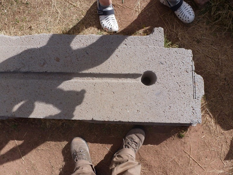
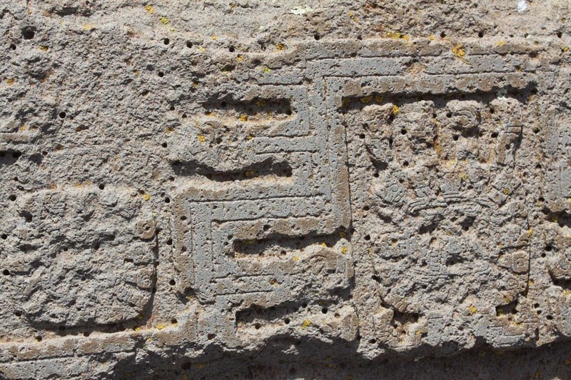
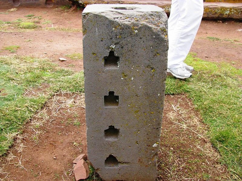
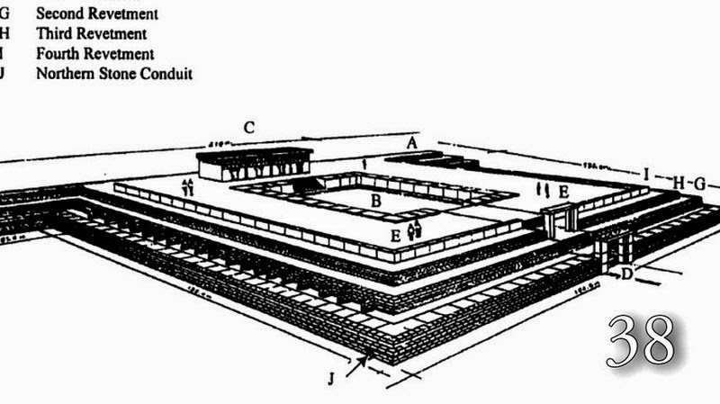
Satellite picture of Puma punku


Source
READ MORE»

Great Wall of Gorgan

The Great Wall of Gorgan is a series of ancient defensive fortifications located near Gorgan in the Golestān Province of northeastern Iran, at the southeastern corner of the Caspian Sea. At 195 km long, the wall is second only to the Great Wall of China as the longest defensive wall in existence, but until recently, nobody knew who had built it. Theories ranged from Alexander the Great, in the 4th century BC, to the Persian king Khusrau I in the 6th century AD. Archeological evidence and scientific dating now suggest that the wall was built in the 5th or 6th century AD, by the Sassanian Empire. This makes the wall over a thousand years older than the Great Wall of China, and even more impressive is the fact that it’s more solidly built than the early forms of the Great Wall.


The wall is made from tens of millions of standardized red bricks made from the local loess soil and fired in kilns, as opposed to a mixture of earth, brick, wood and stone. These red bricks have given the wall the nickname “Red Snake”.

The length of the wall is not exactly known for its western terminal was flooded by the rising waters of the Caspian Sea, while to the east it runs into the unexplored mountainous landscape of the Elburz Mountains. But the wall was at least 195 kilometers long and 6–10 meters wide. A canal, 5 meters deep, with a continuous gradient ran alongside most of the Wall, conducting water from a reservoir constructed in the highlands down into the Caspian basin. Aside from functioning as a water supply, the canal served as a defensive moat. Along the length of the wall there were built as many as 30 fortresses spaced at intervals of between 10 and 50 km. Researchers estimate that some 30,000 soldiers could have been stationed along its length.

Today, much of the ancient wall lies in ruins, having been eroded over time leaving little more than a scar across the landscape.


A section of the wall.


Source
READ MORE»