Town with No Cell Phones, Wi-Fi or Radio

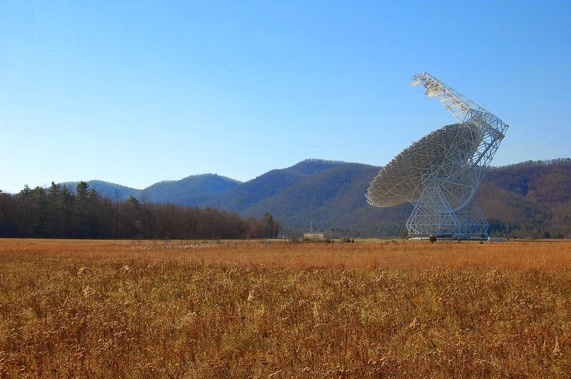
Green Bank, in Pocahontas County in West Virginia, the United States, is possibly one of the quietest residential places on earth. There is no cell phone reception here, no Wi-Fi, not even radio and television. But Green Bank is not technologically backward. On the contrary, it’s home to the world's largest fully steerable radio telescope on earth – the Robert C. Byrd Green Bank Telescope (GBT), operated by the National Radio Astronomy Observatory. The GBT is the reason why this town is electromagnetically silent.

Radio telescopes work by detecting electromagnetic waves that come from distant galaxies. These signals are so faint that the slightest emission of radio waves from electronic gadgets can interfere with the readings of the radio telescopes. For this reason, all cell phones, Wi-Fi, radio and other communication devices are outlawed here. There are no cell phone towers for miles around, no music plays on the radio or soap operas on the television. Not even petrol cars are allowed because gasoline engines use spark plugs to ignite the fuel-air mixture, and electric sparks produce electromagnetic waves.


The boundaries of the device-free zone extend far beyond Green Bank, covering an area roughly equal to 13,000–square-mile. This region is called the National Radio Quiet Zone, and is located around the sparsely populated countryside that straddles the borders of West Virginia, Virginia, and Maryland. Almost all types of radio transmissions and certain electronic devices are banned here so that the powerful Green Bank Radio Telescopes can work without disturbance. Green Bank happens to be the closest community to the Green Bank Telescope.

The tech-free life in Green Bank may seem impossible for those who can’t live without their cell phones, but for the 140-odd residents of the town, life is a bliss. Kids aren't glued to the glowing screens of their mobile devices. They actually talk to each other instead of texting. Older residents roll down their car windows to greet each other and leave their front doors unlocked. If they must speak to someone out of town, there are pay phones.


Living under the shadow of the giant telescope, some of the residents are not even aware of the technological advances elsewhere.

"We didn't realize the rest of the world was getting connected and staying connected constantly, via phones and computers and all that," said radio host Caleb Diller, who grew up in Pocahontas County, to NPR. "So we were kinda back in time a little bit. We hadn't progressed to that."

Over the last few years, many people have taken up residence in Green Bank. These people claim to suffer from electromagnetic hypersensitivity, or EHS—a disease not recognized by the scientific community. It’s said that people suffering from EHS get symptoms like dizziness, nausea, rashes, irregular heartbeat, weakness, and chest pains from electromagnetic radiations.

“Life isn’t perfect here,” said Diane Schou, one of the first “electrosensitive” immigrant who came to Green Bank with her husband in 2007. “There’s no grocery store, no restaurants, no hospital nearby. But here, at least, I'm healthy. I can do things. I'm not in bed with a headache all the time.”


Source
READ MORE»

The Buzludzha Monument

Located at the historical peak of Buzludzha in the Central Stara Planina, Bulgaria, stands a magnificent piece of architecture. The Buzludzha Monument was built by the Bulgarian communist regime to commemorate the events in 1891 when the socialists led by Dimitar Blagoev assembled secretly in the area to form an organized socialist movement. The peak itself was the place of the final battle between Bulgarian rebels led by Hadji Dimitar and Stefan Karadzha and the Turks, in 1868. At one time, the Buzludzha Monument was the most celebrated monument dedicated to the sociopolitical movement of communism. Now, in the mountains of Buzludzha National Park it stands abandoned, vandalized, and devastated.


The saucer-shaped monument rises to a height of 107m, and was designed by the architect Georgi Stoilov. More than 60 Bulgarian artists collaborated on the design of murals for the site, and thousands of ‘volunteers’ were involved in the construction process, which took almost seven years to complete. In the 15 meter-high main hall of the memorial a 500 sq.m. fresco present portraits of Marx, Engels, Lenin and the Bulgarian communist leader Todor Zhivkov. The dome of the structure was covered with thirty tones of cooper. Two 12m stars of ruby glass was built-in on the top of the 70m high pylon of the monument that symbolizes a waving communist flag. The Soviet star which adorns the tower of Buzludzha was three times larger than that at the Kremlin.

Scrawled above the main entrance in red paint, Latin characters spell out the phrase ‘FORGET YOUR PAST’, flanked on either side by powerful socialist stanzas emblazoned in Bulgarian Cyrillic.

Bulgarian Communism came to an end in 1989, and immediately afterwards, the headquarter came into disuse. In 1991 the monument, which still belonged to the ex-communist party, was ceded to the state and was abandoned, looted and left to self-destruction.


Source
READ MORE»

Whittier Tunnel Alaska

This unassuming slanted roof, house-like structure at the foot of the mountain may appear like a private residence or perhaps a garage, but really is the entrance to the second longest highway tunnel and longest combined rail and highway tunnel in North America. Located fifty miles southeast of Anchorage, near Portage Glacier, in the U.S. state of Alaska, the Anton Anderson Memorial Tunnel, also referred to simply as the Whittier Tunnel, connects the port city of Whittier on Prince William Sound to the Seward Highway. The 4,100 meter-long tunnel passes wholly under Maynard Mountain. It was built during the second World War, at the cost of $80 million, and is the first tunnel in the U.S. that allows automobiles to drive directly over the track area - a design that saved tens of millions of dollars compared to what would have cost if the tunnel was widened to allow the roadway to be separated from the track. The tunnel was named after Anton Anderson, an engineer for the United States army who played a principal role in the construction of the tunnel.


A vehicle enters the Anton Anderson Memorial Tunnel, North America’s longest combined rail-highway tunnel.

Whittier Tunnel is just 16 feet wide and has a single lane shared by both rails and cars. Rail and road traffic are coordinated by two sophisticated computer-based systems which control the timing of vehicles entering the tunnel, spacing them for safety, and lower railroad gates when a train is approaching. Cars heading to Whittier are allowed every half hour while cars leaving Whittier can enter the tunnel every hour. In between regularly scheduled passenger trains are also accommodated.

The tunnel interior is exposed to the natural rock - only portions of the tunnel are lined with concrete and steel. The majority of the tunnel has a wire mesh attached to the ceiling to catch any loose rocks that could work out over time. Inside the tunnel there are several "safe-houses", which are small buildings that are used in case of severe earthquakes, vehicle fires, or other emergencies. The tunnel also contains several turnaround spots, which are reserved for disabled vehicles.

Fresh air is pumped into the tunnel using a combination of conventional portal fans and reversible jet fans which look like pretty much like aircraft jet engines.

The tunnel's entrance portals are designed in an A-shape, with a large, train-sized "garage door", which allows traffic in and out of the tunnel. As many as 450 vehicles can wait outside for passing through.


A southbound train exits the Anton Anderson Memorial Tunnel. Northbound vehicular traffic can be seen lining up, waiting its turn to head back through the tunnel toward the Seward Highway.


The 2.5 mile long tunnel has eight safe houses, which can provide refuge during an emergency.


Tunnel control operator Daniel Gutierrez monitors traffic from 60 video cameras at the tunnel control center on Thursday, June 19, 2014. All tunnel operators are also firefighters trained to respond to an accident inside the 2.5 mile long tunnel.


Source
READ MORE»

Petroglyph Beach

Petroglyph Beach is located on the north-west of Wrangell, a town in Alaska. The beach is so called for the large number of petroglyphs resembling eyes, totemic animals and geometric patterns that have been found carved into boulders and the bedrock on this site. These petroglyph are at least 8,000 years old, although their exact dates are uncertain.

The petroglyphs in Wrangell are found scattered near the shore just below the mean water line, revealing themselves during periods of low tide. Most of the petroglyphs can be found close to places of importance such as salmon streams and sites of habitation. Some 40 petroglyphs have been discovered till date, making Petroglyph Beach the site of the highest concentration of petroglyphs found in Southeast Alaska. Since 2000, the beach is a State Historic Park.


The fact that most petroglyphs are found on the beach in a narrow band at the mid-tide mark indicates that they were created when the sea level was lower. The ice melted in this region some twelve thousand years ago and sea levels began to rise. So, the earliest petroglyphs may be many thousands of years old, carved at a time of lower sea levels.

It is generally believed that the petroglyphs were created by the ancestors of the present day Tlingit tribe because of the similarity in the symbols and the artistic style used in the petroglyphs with those found in historic and current Tlingit totemic art. Many of these carvings depict whales, salmon, and faces of the community.

As the petroglyphs were mainly located near the mouths of salmon streams and could only be seen from the sea side, these petroglyphs could be a way to invoke the gods to send salmons for spawning every year which they hunted for food, or perhaps a thank-you to the gods for bountiful hunts. Another possibility is that the designs could serve as territorial markers for a good hunting area or ownership of fishing ground.

The rock here is metamorphic and tends to be a dark gray that is finely grained, moderately hard and durable, and easy to fracture, which would make it easier to carve. But that also makes the rocks prone to damage. Hence touching or walking on the rocks is prohibited. There is an accessible boardwalk to a deck overlooking Petroglyph Beach. On the deck replicas of several designs are displayed for visitors to make rubbings on.


Source
READ MORE»

Frost Flowers

It is as beautiful as it is rare. A frost flower is created on autumn or early winter mornings when ice in extremely thin layers is pushed out from the stems of plants or occasionally wood. This extrusion creates wonderful patterns which curl and fold into gorgeous frozen petioles giving this phenomenon both its name and its appearance.

Conditions have to be just so for frost flowers to form. Early winter and late autumn are the optimum time to come across them as although the weather conditions must be freezing it is vital that the ground is not.


As the temperature gets to freezing or below the sap in the stem of the plants will expand. As it does so the outer layer of the stem comes under increasing pressure and microscopically thin cracks, known as linear fissures, begin to form. These will finally give way under the pressure of the sap and split open.


Water is continuously being drawn up the plant’s stem while the ground remains unfrozen. It travels up the plants external structural axis (stem!) and reaches the split or splits. As it does so, it oozes slowly out and it freezes. Yet more water is coming behind it.


This new water reaches the cracks and it too freezes, pushing the previous slither of ice away from the stem. In this manner the amazing ‘petals’ that you see in these pictures are formed.


Incredibly, the frost flower effect can happen to wood even when it has been made in to a fence or a gate, as seen above. In this case the water is extruded through the pores in the wood rather than cracks.


The frost flower has a number of other names: you may know them as frost castles, ice castles, ice blossoms, or even the very scientific sounding crystallofolia. Yet the name is something of a misnomer: frost is created by water vapor. Frost flower, on the other hand, are formed from liquid water.


If you come across one – be careful! Rather than attempt to pick it up, if you have a camera or a phone with you take a picture instead. Frost flowers are incredibly delicate and will more often than not shatter when touched.


Source
READ MORE»