A causeway is a road or railway route across a broad body of water or wetland raised up on an embankment. Some causeways may only be usable at low tide and the distinction between causeways and viaducts can become blurred when flood-relief culverts are incorporated in the structure; a causeway is however primarily supported on earth or stone, whereas a bridge or viaduct is mainly supported by free-standing columns or arches.
1. Great Salt Lake Causeway, USA

The causeway running across the Great Salt Lake, Utah, was built in the 1950s by the Morrison-Knudsen construction company for the Southern Pacific Railroad as a replacement to a previously built wooden trestle, and is now owned and operated by Union Pacific.

About 15 trains cross the 20-mile (32km) causeway each day. Because water flow is so constrained by the causeway, it has a significant impact on various industries. The salt discrepancy is visible to anyone who flies over the causeway. The water on the north side usually has a distinct reddish tint, while on the south side it's greenish-blue. The colors are attributed to different species of algae that thrive in different concentrations of salt.

The unusual color scheme is a direct result of the causeway. The original trestle allowed water to flow freely under the railroad tracks, but the causeway that replaced it essentially acts as a 20-mile (32km) dam. The salt imbalance developed over many years because the south arm of the lake gets nearly all the freshwater.

There are no significant creeks or rivers flowing into the north arm, while the south arm gets flushed continually by waters of the Jordan, Weber and Bear Rivers.
2. Hindenburg Dam, Germany

Hindenburg Dam is an 11 km-long (7mi) causeway joining the North Frisian island of Sylt to mainland Schleswig-Holstein. It was opened on 1 June 1927 and is exclusively a railway corridor. A train trip along the causeway takes about 10 minutes, and the time between the auto terminals at Niebüll on the mainland and Westerland on Sylt is about 30 minutes.

The Hindenburg Dam is part of the railway line known as the Marschbahn ("Marsh Railway"), which is double-tracked along much of the route, although there as yet exists a single-tracked stretch. On the causeway is a signal box. Every day, more than 100 trains pass over the causeway, 50 of those ferrying cars (there is no road link to Sylt).

Each year, the railway ferries more than 450,000 vehicles over the causeway. The causeway, which bears the Weimar Republic Reichspräsident Paul von Hindenburg's name, has interrupted the tidal flow, which until the causeway's appearance had flowed freely between Sylt and the mainland.

This change in tides, it is believed, is part of what has led to the loss of a certain amount of land at Sylt's southern end. The causeway lies in the specially protected Zone I of the Schleswig-Holsteinisches Wattenmeer National Park. Walks on the tidal flats are not allowed here, although they are quite popular elsewhere.
3. Passage du Gois, France

Le Passage de Gois ou Gôa is a natural, periodically flooded causeway leading to the island of Noirmoutier in France. It is located between Île de Noirmoutier and Beauvoir-sur-Mer, in the department of Vendée. Causeway is flooded twice a day by the high tide. Every year, a foot race – the Foulées du Gois– is held across it, starting at the onset of the high tide.

In 1999 Passage du Gois was used by Tour de France bicycle race during Stage 2. It proved to be decisive for the race after a fall took place because of its slippery surface.

Tour de France
The crash created a six minute split in the peloton which ended the hopes of many favourites to win the race, like Alex Zülle, who would eventually finish second overall, seven minutes after Lance Armstrong. Passage du Gois was used again in 2011 as the starting point of the first stage.
4. Funafuti Causeway, Tuvalu

Made up of four coral islands and five atolls off the coast of Australia, Tuvalu has a maximum height of only 4.5 meters (15 feet) above sea level. There's a section on island of Funafuti where the island was too narrow for a road, so they built this concrete section that they refer to as "the causeway".

This causeway is quite important for local traffic, because it connects the northern and southern part of the island. As you can see in the picture above, waves often wash over this causeway.
5. Causeway Between Jindo and Modo Islands, South Korea

The tide-related sea level variations result in a local phenomenon (a "Moses Miracle") when a land pass 2.9 km (1.8 mi) long and 10–40 meters (11-33 yds) wide opens for an hour between Modo and Jindo islands (Jindo County, South Jeolla province).

The event occurs approximately twice a year, around April-June. It had long been celebrated in a local festival called "Jindo's Sea Way", but was largely unknown to the world until 1975, when the French ambassador Pierre Randi described the phenomenon in a French newspaper. Nowadays, nearly half a million foreign and local tourists attend the event annually.
6. Rough Island Causeway, UK

Rough Island is accessible across the causeway from Kippford when the tides allow or across the mudflats from Rockcliffe, the isle of Rough can be walked to from the Scottish mainland.

As the island is a bird sanctuary visitors should avoid travelling to the island during the months of May and June to avoid disturbing the nesting oystercatchers and ringed plovers. The islands' causeway is flooded and underwater for 5 (five) hours during high tide and visitors to the island need to take this into account when travelling there.
7. Låningsvejen, Denmark

Mandø is one of the Danish Wadden Sea islands off the southwest coast of Jutland, Denmark in the Wadden Sea, part of the North Sea.

Island is barely accessible at high tide over an unpaved surface level causeway of about four kilometers (2.5 mi) in length that connects the island to the mainland.

Mandøbussen link
Låningsvejen is the name of this causeway which connects Mandø to the mainland in Jutland. It is a public road which you can use if you know the tides and when it is low tide. Only the two tractor busses “Mandø Traktorbus” and “Mandøbussen” are allowed to use “Ebbevejen”. They carry the post, school children and tourist to and from the island.
8. Colchester Causeway, USA

Along the edges of Lake Champlain (Vermont) is a scenic 12-mile (19,3km) trail that extends from downtown Burlington north through Colchester onto the Causeway. It's a multi-use trail so you will see walkers, runners, inline skaters and bikers.

It's wide enough and relatively flat so jogging strollers or burlees are do-able for the little ones. It is paved with the exception of 5 miles (8km) in Colchester.

The causeway connects the 7.5 mile (12km) bike path and intersects with Colchester Airport Park and unites with the Island Line in South Hero. This is a wonderful 14 mile (22,5km) trail that travels along Lake Champlain. The trail is unpaved and lined with large boulders on each side. The view from the causeway is unbelievable.
9. Julia Tuttle Causeway, USA

The Julia Tuttle Causeway carries Interstate 195 across Biscayne Bay. Interstate 195 (I-195) is a 4.424-mile-long (7.120 km) spur freeway connecting I-95 (its parent route) in the west with Miami Beach in the east.

Causeway is named after Miami founder Julia Tuttle. Construction of Interstate 195 (Florida) began in 1959, culminating with an opening on December 23, 1961. The Julia Tuttle Causeway was widened from 1988-1990 to improve the shoulders.

The Julia Tuttle Causeway is 4 kilometers (2.5mi) long and has a 6 lane of I-195. Traffic lanes are in the middle of the causeway, and between them and the water stretching lines of trees.
10. Gated Causeway, USA

A gated causeway (Caritas Island, Connecticut) leads to a four-acre island compound with a restored 14,000-square-foot (1.300 sqm) english manor, dock, lap pool, beach, koi pond, three-bedroom guest cottage and carriage house. Caritas Island is currently on the market for $12.8 million.
11. The Amador Causeway, Panama

The Amador Causeway Panama is a six kilometer (3.7mi) long causeway which is a must see for any visitor to Panama City. Any given day of the week the Amador Causeway is bustling with tourists taking in the spectacular views of Panama City. There are people watching as ships enter the passage to the Panama Canal, locals going to dinner, families taking a stroll along the sidewalk, athletes exercising, sailors coming in off the ships, travelers heading to the local islands off the coast and people taking advantage of the Duty Free store on the Flamenco Island.

The Amador Causeway is made up of four islands. The islands are Naos Island, Culebra Island, Perico Island and Flamenco Island at the end of the chain of islands. The causeway was originally constructed as a breakwater for the Panama Canal entrance. Over the last century the islands have transformed. During World War II the islands were utilized by the US military as a post to protect against an attack on the Panama Canal. Today we have a bustling tourist destination. The Amador Causeway was constructed using rocks excavated from Culebra Cut and Gaillard Cut during the excavation of the Panama Canal. Originally the breakwater only reached Naos Island. The fill used for the causeway was brought in by an ingenious rail system from the canal excavation sites.
12. Causeway Kunoy, Faroe Islands
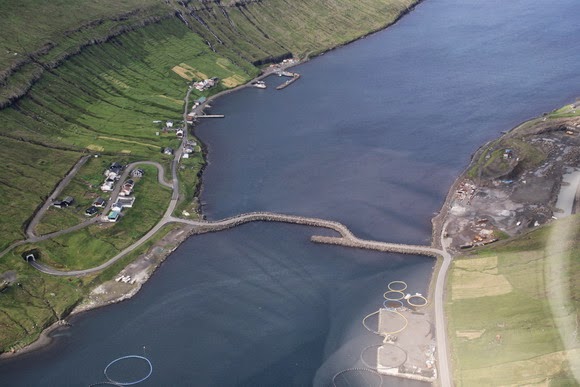
The causeway between Borðoy island (right) and Kunoy island (left), Faroe Islands. On Kunoy the village of Haraldssund can be seen.

The reason for the unusual form of the causeway is unknown to us. In Haraldssund, the entrance to the 3km (1.9mi) one-lane tunnel to the 'bygd' of Kunoy is visible, as well as a quarry on Borðoy, and some aquaculture rings in the water.
Source
READ MORE»
1. Great Salt Lake Causeway, USA
The causeway running across the Great Salt Lake, Utah, was built in the 1950s by the Morrison-Knudsen construction company for the Southern Pacific Railroad as a replacement to a previously built wooden trestle, and is now owned and operated by Union Pacific.
About 15 trains cross the 20-mile (32km) causeway each day. Because water flow is so constrained by the causeway, it has a significant impact on various industries. The salt discrepancy is visible to anyone who flies over the causeway. The water on the north side usually has a distinct reddish tint, while on the south side it's greenish-blue. The colors are attributed to different species of algae that thrive in different concentrations of salt.
The unusual color scheme is a direct result of the causeway. The original trestle allowed water to flow freely under the railroad tracks, but the causeway that replaced it essentially acts as a 20-mile (32km) dam. The salt imbalance developed over many years because the south arm of the lake gets nearly all the freshwater.
There are no significant creeks or rivers flowing into the north arm, while the south arm gets flushed continually by waters of the Jordan, Weber and Bear Rivers.
2. Hindenburg Dam, Germany
Hindenburg Dam is an 11 km-long (7mi) causeway joining the North Frisian island of Sylt to mainland Schleswig-Holstein. It was opened on 1 June 1927 and is exclusively a railway corridor. A train trip along the causeway takes about 10 minutes, and the time between the auto terminals at Niebüll on the mainland and Westerland on Sylt is about 30 minutes.
The Hindenburg Dam is part of the railway line known as the Marschbahn ("Marsh Railway"), which is double-tracked along much of the route, although there as yet exists a single-tracked stretch. On the causeway is a signal box. Every day, more than 100 trains pass over the causeway, 50 of those ferrying cars (there is no road link to Sylt).
Each year, the railway ferries more than 450,000 vehicles over the causeway. The causeway, which bears the Weimar Republic Reichspräsident Paul von Hindenburg's name, has interrupted the tidal flow, which until the causeway's appearance had flowed freely between Sylt and the mainland.
This change in tides, it is believed, is part of what has led to the loss of a certain amount of land at Sylt's southern end. The causeway lies in the specially protected Zone I of the Schleswig-Holsteinisches Wattenmeer National Park. Walks on the tidal flats are not allowed here, although they are quite popular elsewhere.
3. Passage du Gois, France
Le Passage de Gois ou Gôa is a natural, periodically flooded causeway leading to the island of Noirmoutier in France. It is located between Île de Noirmoutier and Beauvoir-sur-Mer, in the department of Vendée. Causeway is flooded twice a day by the high tide. Every year, a foot race – the Foulées du Gois– is held across it, starting at the onset of the high tide.
In 1999 Passage du Gois was used by Tour de France bicycle race during Stage 2. It proved to be decisive for the race after a fall took place because of its slippery surface.
Tour de France
The crash created a six minute split in the peloton which ended the hopes of many favourites to win the race, like Alex Zülle, who would eventually finish second overall, seven minutes after Lance Armstrong. Passage du Gois was used again in 2011 as the starting point of the first stage.
4. Funafuti Causeway, Tuvalu
Made up of four coral islands and five atolls off the coast of Australia, Tuvalu has a maximum height of only 4.5 meters (15 feet) above sea level. There's a section on island of Funafuti where the island was too narrow for a road, so they built this concrete section that they refer to as "the causeway".
This causeway is quite important for local traffic, because it connects the northern and southern part of the island. As you can see in the picture above, waves often wash over this causeway.
5. Causeway Between Jindo and Modo Islands, South Korea
The tide-related sea level variations result in a local phenomenon (a "Moses Miracle") when a land pass 2.9 km (1.8 mi) long and 10–40 meters (11-33 yds) wide opens for an hour between Modo and Jindo islands (Jindo County, South Jeolla province).
The event occurs approximately twice a year, around April-June. It had long been celebrated in a local festival called "Jindo's Sea Way", but was largely unknown to the world until 1975, when the French ambassador Pierre Randi described the phenomenon in a French newspaper. Nowadays, nearly half a million foreign and local tourists attend the event annually.
6. Rough Island Causeway, UK
Rough Island is accessible across the causeway from Kippford when the tides allow or across the mudflats from Rockcliffe, the isle of Rough can be walked to from the Scottish mainland.
As the island is a bird sanctuary visitors should avoid travelling to the island during the months of May and June to avoid disturbing the nesting oystercatchers and ringed plovers. The islands' causeway is flooded and underwater for 5 (five) hours during high tide and visitors to the island need to take this into account when travelling there.
7. Låningsvejen, Denmark
Mandø is one of the Danish Wadden Sea islands off the southwest coast of Jutland, Denmark in the Wadden Sea, part of the North Sea.
Island is barely accessible at high tide over an unpaved surface level causeway of about four kilometers (2.5 mi) in length that connects the island to the mainland.
Mandøbussen link
Låningsvejen is the name of this causeway which connects Mandø to the mainland in Jutland. It is a public road which you can use if you know the tides and when it is low tide. Only the two tractor busses “Mandø Traktorbus” and “Mandøbussen” are allowed to use “Ebbevejen”. They carry the post, school children and tourist to and from the island.
8. Colchester Causeway, USA
Along the edges of Lake Champlain (Vermont) is a scenic 12-mile (19,3km) trail that extends from downtown Burlington north through Colchester onto the Causeway. It's a multi-use trail so you will see walkers, runners, inline skaters and bikers.
It's wide enough and relatively flat so jogging strollers or burlees are do-able for the little ones. It is paved with the exception of 5 miles (8km) in Colchester.
The causeway connects the 7.5 mile (12km) bike path and intersects with Colchester Airport Park and unites with the Island Line in South Hero. This is a wonderful 14 mile (22,5km) trail that travels along Lake Champlain. The trail is unpaved and lined with large boulders on each side. The view from the causeway is unbelievable.
9. Julia Tuttle Causeway, USA
The Julia Tuttle Causeway carries Interstate 195 across Biscayne Bay. Interstate 195 (I-195) is a 4.424-mile-long (7.120 km) spur freeway connecting I-95 (its parent route) in the west with Miami Beach in the east.
Causeway is named after Miami founder Julia Tuttle. Construction of Interstate 195 (Florida) began in 1959, culminating with an opening on December 23, 1961. The Julia Tuttle Causeway was widened from 1988-1990 to improve the shoulders.
The Julia Tuttle Causeway is 4 kilometers (2.5mi) long and has a 6 lane of I-195. Traffic lanes are in the middle of the causeway, and between them and the water stretching lines of trees.
10. Gated Causeway, USA
A gated causeway (Caritas Island, Connecticut) leads to a four-acre island compound with a restored 14,000-square-foot (1.300 sqm) english manor, dock, lap pool, beach, koi pond, three-bedroom guest cottage and carriage house. Caritas Island is currently on the market for $12.8 million.
11. The Amador Causeway, Panama
The Amador Causeway Panama is a six kilometer (3.7mi) long causeway which is a must see for any visitor to Panama City. Any given day of the week the Amador Causeway is bustling with tourists taking in the spectacular views of Panama City. There are people watching as ships enter the passage to the Panama Canal, locals going to dinner, families taking a stroll along the sidewalk, athletes exercising, sailors coming in off the ships, travelers heading to the local islands off the coast and people taking advantage of the Duty Free store on the Flamenco Island.
The Amador Causeway is made up of four islands. The islands are Naos Island, Culebra Island, Perico Island and Flamenco Island at the end of the chain of islands. The causeway was originally constructed as a breakwater for the Panama Canal entrance. Over the last century the islands have transformed. During World War II the islands were utilized by the US military as a post to protect against an attack on the Panama Canal. Today we have a bustling tourist destination. The Amador Causeway was constructed using rocks excavated from Culebra Cut and Gaillard Cut during the excavation of the Panama Canal. Originally the breakwater only reached Naos Island. The fill used for the causeway was brought in by an ingenious rail system from the canal excavation sites.
12. Causeway Kunoy, Faroe Islands
The causeway between Borðoy island (right) and Kunoy island (left), Faroe Islands. On Kunoy the village of Haraldssund can be seen.
The reason for the unusual form of the causeway is unknown to us. In Haraldssund, the entrance to the 3km (1.9mi) one-lane tunnel to the 'bygd' of Kunoy is visible, as well as a quarry on Borðoy, and some aquaculture rings in the water.
Source