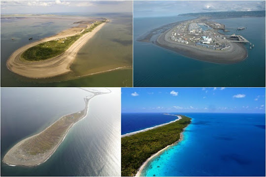
Spurn Point
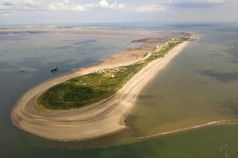
Spurn Point is one of the most striking feature of Britain's coastline – a narrow spit just 46 meters across, on the tip of the coast of the East Riding of Yorkshire, jutting out into the sea for five and a half kilometers across the Humber Estuary. On the tip is an enlarged head wherein lies a disused lighthouse and a lifeboat station.
Spurn Head covers 280 acres and composed of sand and shingle banks held together by Marram grass and Seabuckthorn. Spurn is a relatively small place, yet an important wildlife haven for migrant birds, lizards, roe deer and numerous species of insects. Being open to the ravages of the North Sea, this narrow strip of land has a very delicate ecosystem. On one side, plants have learned to adapt themselves to being immersed in water every 12 hours, while on the other side, where the sand is moving around, you’ll find plants designed to retain moisture.
Spurn Point is a nice place for birdwatchers – there are even accommodation for overnight stay. On a good autumn morning one can see 15,000 birds fly past with 3,000 quite normal.


Farewell Spit
Farewell Spit is located at the northern end of the South Island of New Zealand, running eastwards from Cape Farewell, the island's northernmost point. It is the longest sandspit in New Zealand, stretching for about 26 km above sea level and another 6 km underwater. The spit runs in from west to east, and is made from fine golden sand – the spit is large enough to have its own sand dunes.
The northern side of the dunes are steeper and unstable being constantly exposed to the prevailing winds which average over 25 km/h. The southern side, that which faces Golden Bay is more stable and largely covered with vegetation. The tide here can recede as much as seven kilometers exposing some 80 square kilometers of mud flats - a rich feeding ground for the many thousands of sea birds in the area, but also a trap for the frequently stranded whales.
The Spit is administered by the New Zealand Department of Conservation as a sea bird and wild life reserve. Apart from a small area at the base of the Spit it is closed to the public except through organized tours. There is a lighthouse at the end of the spit which you can visit.

NASA satellite image of Farewell Spit.


Arabat Spit
The Arabat Spit in the Sea of Azov is the longest spit in the world at approximately 110 km in length. The spit is located between the town of Henichesk, Ukraine, on the north and the north-eastern shores of Crimea on the south, and separated from Henichesk by the Henichesk Strait. The Arabat Spit ranges from 270 meters to 8 km in width with a total surface area of 395 km2.
The spit is very young and was created by sedimentation processes around 1100–1200 AD. It was wild until 1835 when a road and five stations spaced by 25–30 km were built along it for postal delivery. Later in the 19th century, 25 rural and 3 military settlements and one village named Arabat appeared on the spit. The rural population amounted to some 235 people whose occupation was mostly fishery, farming and salt production. The latter activity is traditional for the region due to the vast areas of shallow and very saline water in the Sivash lagoons. About 24,000 tonnes of salt were produced every year during the 9th century on the Arabat Spit alone.
Around the 17th century, the Turkish army built a fortress to guard the spit and Crimea from invasions. The Arabat Fortress still stands on the southernmost part of Arabat Spit.

Dungeness Spit
Dungeness Spit is 8.9 km long and juts out from the northern edge of the Olympic Peninsula in northeastern Clallam County, Washington, USA, into the Strait of Juan de Fuca. It encloses a body of water called Dungeness Bay. It is the longest natural sand spit in the United States.
The Dungeness Spit is entirely within the Dungeness National Wildlife Refuge and home of the Dungeness Lighthouse. Visitors are allowed to hike all the way to the tip, where the lighthouse has been keeping guard since 1857. The extreme tip, however, like the Dungeness Bay side of the spit, is closed to public entry to protect important wildlife habitat. The refuge is a sanctuary for over 250 species of birds, 41 species of land mammals and eight species of water mammals.


Curonian Spit
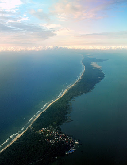
The Curonian Spit is a 98 km long, thin, curved sand-dune spit that separates the Curonian Lagoon from the Baltic Sea coast. It stretches from the Sambian Peninsula on the south to its northern tip next to a narrow strait, across which is the port city of Klaipėda on the mainland of Lithuania. The northern 52 km long stretch of the Curonian Spit peninsula belongs to Lithuania, while the rest is part of the Kaliningrad Oblast, Russia. The width of the spit varies from a minimum of 400 m in Russia to a maximum of 3,800 m in Lithuania.
The Curonian Spit is home to the highest drifting sand dunes in Europe. Their average height is 35 meters, but some attain the height of 60 meters. The spit is frequently visited by migratory waterfowl. Between 10 and 20 million birds fly over the feature during spring and fall migrations, and many pause to rest or breed there.
The spit also has several towns, the largest of which is Nida in Lithuania, which is a popular holiday resort, mostly frequented by Lithuanian and German tourists.


La Manga del Mar Menor
La Manga del Mar Menor or simply La Manga is a seaside spit in the Region of Murcia, Spain, about 22 km long and 100 metres wide on average, separating the Mediterranean Sea from the Mar Menor (Minor Sea) lagoon, from Cabo de Palos to the Punta del Mojón.
La Manga sandbar is cut off by natural channels that keep the two seas in contact with each other. As such, the space was untouched until the 1960s, when La Manga was discovered as a tourist resort and underwent a transformation which included the urbanisation of the area and the construction of tourist infrastructures. Today, La Manga is densely populated.


Homer Spit
The Homer Spit is located in Homer, Alaska, on the southern tip of the Kenai Peninsula, jutting out into Kachemak Bay for 7.2 km. The spit is home to the Homer Boat Harbor that serves up to 1,500 commercial and pleasure boats at its summer peak.
The spit was inhabited by early natives who probably camped out there. A more permanent habitation grew up much later with the arrival of Americans. The turn-of-the-century settlers found the easterly end of the Spit a handy place to land boats and early-day coal shipping led to construction of a wharf and a company town there. When coal mining faded and fisheries became the focus, the wharf and eventually the harbor developed into an even more important key to the local economy.
The spit includes several attractions such as “The Nick Dudiak Fishing Lagoon”, which is an artificial "fishing hole", campgrounds, hotels, and restaurants and the Salty Dawg Saloon, which is constructed out of several historic buildings from Homer. The Spit features the longest road into ocean waters in the entire world, taking up 10–15 minutes to cover by car. Hundreds of eagles gathered there in winter.


Source
