Lakes of Ounianga in Sahara Desert

The Lakes of Ounianga consist of 18 lakes located in the heart of the Sahara Desert, in an extremely arid region of northern Chad where the average yearly rainfall is no more than 2 mm. They depend on an underground supply of ‘fossil’ water that fell on this area in ancient times when the Saharan climate was much wetter than it is today. Approximately 14,800 to 5,500 years ago the area was occupied by a single large lake, probably tens of kilometers long. As the climate dried out during the subsequent millennia, the lake shrank, and large, wind-driven sand dunes invaded the original depression, dividing it into several smaller basins. The 18 lakes is all that remains today.

The lakes are situated in a shallow basin below sandstone cliffs and hills, from where the ancient water flows. The almost-year-round northeast winds and cloudless skies make for very high evaporation rates. But the underground bed of water-rich rocks are large enough to keep supplying the small lakes with water despite the high evaporation rate. Remarkably, this unique hydrological system is able to sustain the largest permanent freshwater lakes to be found in such an arid desert environment anywhere in the world.
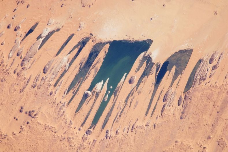

A NASA image taken on November 14, 2009, by the crew of the ISS.

The lakes are divided into two groups, 40km apart. They vary greatly in chemical composition, some being so salty that they can only support the most basic forms of life, while others are fresh enough to provide habitat for aquatic plants, fish and a diversity of other species. The largest and most biologically important lake (Lake Teli, in the eastern group known as Ounianga Serir) has a surface area of 4.4km2 and a maximum depth of 10 m. Its water is fresh, and supports an abundance of life. The sandy substrate is highly porous, so water flows freely underground between Lake Teli and 13 other smaller lakes in the eastern group.

Further west, across the dunes and sandstone ridges that characterise this part of the Sahara, the second group of four lakes (known as Ounianga Kebir) is found, dominated by Lake Yoan (3.6 km2 and 27 m deep). This is a hyper saline lake which supports only algae and a few other micro-organisms. Rocks around its shores are encrusted in white salt deposits, and a sprawling village of some 9,000 people is spread amongst the nearby hills and dunes.

The lakes of Ounianga form as exceptional natural landscape of great beauty with striking colours and shapes. Because of its remote location, only a trickle of fearless tourists (about 500 annually) finds its way to this remote corner of Chad.


Source
READ MORE»

Mud Volcanoes - Bledug Kuwu

Bleduk Kuwu is a crater of mud in Wirosari area in Grobogan Region, Purwodadi, Central Java. Every two or three minutes, the placid water of Bleduk Kuwu erupts in an explosion of mud, followed by a plume of white steam. For local people, “bledug” means explosion and “kuwu” or “kuwur” means to be scattered. The place has been a tourist destination for decades.

Located several minutes by car from Blok Cepu mining site, Bledug Kuwu is somehow identical to the mudflow in Sidoarjo, East Java. If Sidoarjo's mudflow has displaced nearby residents and brought misery to the people, Bledug Kuwu has helped local people earn money. People living near this site make money by selling salt to visitors. The salt is harvested from volcanic sediment that is dried in an open field.

Visitors can watch the geyser from a distance of between 10 meters and 20 meters. The eruptions of water and mud shift positions from time to time, but there are two spots where the geyser regularly erupts. The locals call the one in the east Mbah (Grandpa) Jokotua and the one in the west Mbah (Grandma) Rodenok.


Legend has it that the explosion comes from a tunnel that connects the site to the mystical "Laut Selatan" or Indian Ocean. The tunnel is a passage for a mystical knight, Joko Linglung, and allows him to move between Laut Selatan and the Medang Kamulan Kingdom, the area of which includes today's Grobogan.

The natural phenomenon is caused by the release of gas, usually methane, from inside the earth bed.


Source

READ MORE»

Tatra Mountains - Tallest Mountains in Poland

The Tatra Mountains, also known as the ‘Tatras’ or ‘Tatra’, are a mountain range which forms a natural border between Slovakia and Poland. The peaks of Gerlach (Slovakia) and Rysy (Poland) represent the highest points in each country.

Below we will take a photo tour of this beautiful range through the lens of Polish photographer Jakub Polomski. He has fond memories of the Tatra Mountains as they were often the subject of his work when he was first getting into photography.

We will also sprinkle some facts about this beautiful and biologically diverse range throughout the stunning visuals. Enjoy!


The Tatras occupy an area of 750 km² (290 mi²), of which the greater part (600 km²/232 mi²) lies in Slovakia, with the highest peak Gerlach at 2,655 m (8710 ft), located north of Poprad. In turn, summit Rysy (2,499 m/8200 ft), located in the north-western part of Tatras, is the highest mountain in Poland.


The Tatras lie in the temperate zone of Central Europe. They are an important barrier to the movements of air masses. Their mountainous topography causes one of the most diverse climates in that region.


Temperatures range from -40 °C (-40 °F) in the winter to 33 °C (91 °F) in warmer months. Temperatures also vary depending on altitude and sun exposure of a given slope. Temperatures below 0 °C (32 °F) last for 192 days on the summits.


The Mountains have a diverse variety of plant life. They are home to more than 1,000 species of vascular plants, about 450 mosses, 200 liverworts, 700 lichens, 900 fungi, and 70 slime moulds. There are five climatic-vegetation belts in the Tatras.


The Tatra Mountains are home to many species of animals: 54 tardigrades, 22 turbellarians, 100 rotifers, 22 copepods, 162 spiders, 81 molluscs, 43 mammals, 200 birds, 7 amphibians and 2 reptiles.


The Polish part of the Tatras was formally declared a national park in 1955. The lower and middle parts of the range are cloaked in forest.


Source
READ MORE»

Commagene Kingdom at Mount Nemrut

Mount Nemrut also called Mount Nemrud is one of the most interesting tourist attractions of Turkey. At the summit of this approximately 2000 meter mountain lies the ruins of the ancient Commagene Kingdom which was at its height of power during the 1st century B.C. The mountain lies 40 km north of Kahta, near Adıyaman. Mount Nemrut is part of the Taurus mountain range, above the Firat (Euphrates)River valley and a grassy plateau, within the boundaries of Karadut village near Kahta.

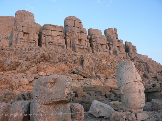
This spectacular structure is made of large slabs of rock to form a pyramid-like configuration. The east and west terraces of this mound are open-air temples. On these terraces are immense statues of lions, eagles, five gigantic god statues, four male and one female, most of which are amazingly well preserved.

The Commagene, which means the “community of genes”, was founded as an independent kingdom by Mithridates Kallinikos I at the beginning of the 1st Century BC after a civil war which terminated the Seleucid line. The kingdom raised to prominence during the reign of Antiochus Epiphanes (62-32 BC), the son of Mithridates Kallinikos.


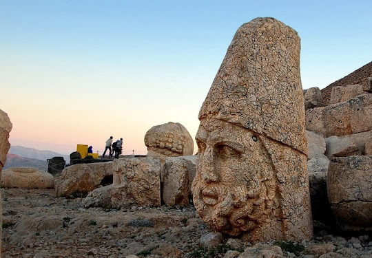
In 62 BC, King Antiochus I Theos of Commagene built on the mountain top a tomb-sanctuary flanked by huge statues of himself, two lions, two eagles and various Greek, Armenian, and Iranian gods, such as Hercules-Vahagn, Zeus-Aramazd or Oromasdes (associated with the Iranian god Ahura Mazda), Tyche, and Apollo-Mithras. These statues were once seated, with names of each god inscribed on them. The heads of the statues have at some stage been removed from their bodies, and they are now scattered throughout the site.

The pattern of damage to the heads suggests that they were deliberately damaged because of belief in iconoclasm. The statues have not been restored to their original positions. The site also preserves stone slabs with bas-relief figures that are thought to have formed a large frieze. These slabs display the ancestors of Antiochus, who included both Greek and Persians.

The same statues and ancestors found throughout the site can also be found on the tumulus at the site, which is 49 m (161 ft) tall and 152 m (499 ft) in diameter. The statues appear to have Greek-style facial features, but Persian clothing and hairstyling.

The western terrace contains a large slab with a lion, showing the arrangement of stars and the planets Jupiter, Mercury and Mars on 7 July 62 BC. This may be an indication of when construction began on this monument. The eastern portion is well preserved, being composed of several layers of rock, and a path following the base of the mountain is evidence of a walled passageway linking the eastern and western terraces. Possible uses for this site is thought to have included religious ceremonies, due to the astronomical and religious nature of the monument.

The best time to visit Mt. Nemrut is between May 15 and October 15. Touring vehicles can be hired from Adiyaman or Kahta district. One of the favorite activities here is watching the sunrise and sunset because of the magnificent views offered from the summit.


Source
READ MORE»

When Lava Meets The Sea

Nick Selway is a 28-year-old professional photographer from Lake Stevens, Washington. During college with no declared major, Nick decided to take a photography class that would change his life. He had found his purpose and passion and moved to Kailua Kona on the Big Island of Hawaii after graduation. Selway and his best friend, CJ Kale, own Lava Light Galleries together in Kailua Kona, Hawaii. They spend a great amount of time on the active volcano and travel a few months out of each year to bring their own unique view of the world to everyone.

In the series by Nick Selway below, we see the awesome power of nature as lava meets water off the shores of Hawaii. The largest and most southeastern island of the chain, Hawaii (Big Island), consists of five volcanoes. Kilauea, Mauna Loa and Hualalai have erupted in the past 200 years. Kilauea is one of the most active volcanoes in the world while Mauna Loa is the world’s largest volcano in terms of volume and area covered.


Source

READ MORE»

Horizontal Waterfalls, Australia

The Horizontal Falls or Horizontal Waterfalls are located in the Talbot Bay in the Kimberley region of western Australia. Although called waterfalls, this natural phenomenon actually consist of a pair of openings or gorges in the McLarty Range through which massive amount of water are pushed by tidal waves, creating temporary waterfalls up to 5 meters high. When the tide changes, so does the direction of the flow.

The twin gaps are located on two ridges running parallel approximately 300 meters apart. The first and most seaward gap is about 20 meters wide and the second, most spectacular, gap is about 10 meters wide. When the rising or falling tide occurs, the water builds up in front of the gaps faster than it can flow through them. This in turn creates an amazing waterfall effect as the water rushes through and then down to the lower levels on the other side of the ridgelines. The process is reversed and it is repeated again in the opposite direction.


The tides in this area have a 10 meter variation which occurs over six and a half hours from low tide to high tide and vice versa. On a slack tide it is possible to drive boats through the two gaps to the bay behind.

The waterfall phenomena has been described by David Attenborough as "one of the greatest natural wonders of the world".


Source
READ MORE»