Thermogenesis Phenomenon

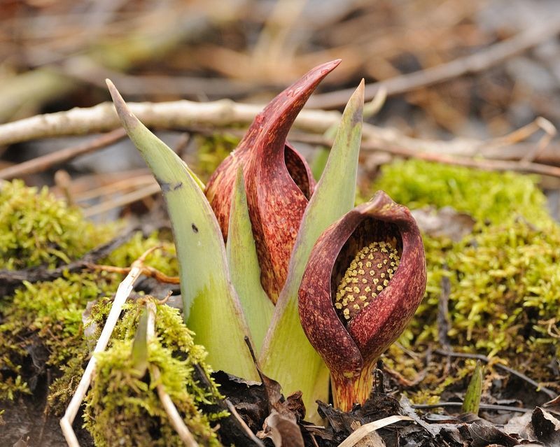
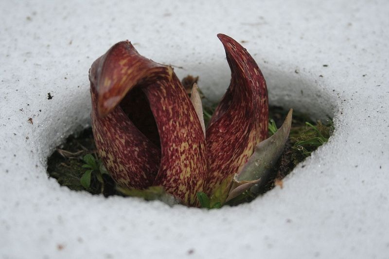
Between late February and May, in woodlands and wetlands throughout eastern Canada and the northeast United States, you’ll find a low growing, foul-smelling plant called skunk cabbage (Symplocarpus foetidus). The skunk cabbage is one of the first plants to emerge in the spring when the winter snow is yet to melt. As the plant pokes its head out of the snow and starts flowering, it forms a small pool of water around it, created by snow melt. The heat needed to melt the snow is derived not from the sun but generated by the plant itself. Skunk cabbage is one of the few species in the Plant Kingdom, belonging to ancient lineages of flowering plants, that has the rare ability to generate heat — a phenomenon known as thermogenesis.


The flower of a skunk cabbage melts snow around it by its heat.

Thermogenic plants are found in a variety of families, but Araceae in particular contains many such species. Skunk cabbage, the dead-horse arum, the elephant yam and Philodendron selloum, are a few examples of thermogenic plants belonging to the Araceae family. These plants can generate significant amounts of heat that even mammals can’t, and their rate of heat production actually increases the colder the environment gets.

In an experiment, skunk cabbages were found to maintain flower temperature 9°C higher when the air temperature was at 15°C. When the air temperature was dropped to –15°C, the flower was still at 15°C, or 30° higher than the air temperature.

The Asian sacred lotus (Nelumbo nucifera) can also regulate its flower temperature. Measurements showed that flower temperatures stayed at a warm 30°C to 36°C even when environmental temperatures dropped as low as 10°C. Another species Philodendron selloum is even better at temperature regulation. In lab tests, the flowers managed to stay between 30°C and 36°C even when scientists chilled the air to 4°C.

The dead horse arum (Helicodiceros muscivorus), another obnoxious smelling plant, reportedly produces more heat than any other known plant or animal considered in its entirety.


Knowledge of heat generating plants date back more than 200 years but it’s only recently researchers have started to unravel the biochemistry behind it. It’s now know that the heat is generated in the mitochondria, as a secondary process of cellular respiration, although the actual process is still poorly understood.

Biologists believe thermogenic plants generate heat to assist in pollination. The heat renders the flower’s fragrance more volatile which helps the scent to spread more widely so that pollinating insects can find them from far away. The dead horse arum, which smells like rotten meat, uses heat not only to attract flies and beetles but also to convince them that it’s a dead carcass. The heat also makes the thermogenic plants attractive to insects seeking warmth and comfort.

But a flower that offers pollinators just a sip of nectar or a snack of pollen and then sends them on their way has a better chance of dispersing its pollens than a flower that traps insects for a whole night by its hospitality. This is why thermogenesis is not commonly seen among plants. During evolution these heat generating species died out and were replaced by plants having better pollination methods.


The dead-horse arum. This flower has the fragrance of a rotting carcass.


Skunk cabbages blooming in the forest.


Skunk cabbage breaking through the ice.


Source
READ MORE»

The Tree of Life in Kalaloch

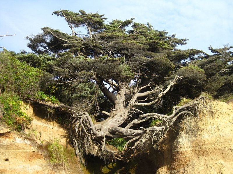
There is an extraordinary tree in Kalaloch beach, within Olympic National Park in Washington, that some people call “the tree of life” because of the miraculous way it seems to be hanging on to life when it should have been dead years ago. The tree is located just north of Kalaloch Lodge, near the Kalaloch Campground, on a cliff that has partially caved in due to erosion — right under the tree. The tree is anchored to the ground by only a few tendrils of roots, but the majority of them are exposed and spread out over a void. It’s a miracle that the tree is still breathing and thriving and sprouting fresh green leaves every spring despite having no soil underneath. No one knows why the tree has not toppled over during the intense storms that the coast is known for.


The tree is a Sitka spruce, but there is no official name. So people have been calling it by various names such as “the tree of life” and “the runaway tree”. Underneath the tree, is a cave like hollow that some people call “the tree root cave”. I couldn’t find how old the tree is or for how long it is hanging there for dear life.

The cave under the tree was caused by a small stream that empties into the ocean and has been washing the soil out from underneath it. I gather that this happened many decades ago, as can be inferred from this passage I read at lubin-king.com, written in 2005:

As we approached the tree, a couple that was walking towards the bluff commented that they had been coming to this campground for 17 years and each year they had been expecting the tree to fall, but it hadn’t happened yet.


Source:
READ MORE»

Unexploded Bombs Find Everyday Use in Laos

The Vietnam War ended 40 years ago, but left a deadly legacy, especially in Laos. The US military dropped more than 2 million tons of bombs on the country during the war between 1964 and 1973, making Laos the most heavily bombed country in the world on a per capita basis. There were more than 580,000 bombing missions on Laos, equivalent to one bombing mission every eight minutes, 24 hours a day, for nine years. Not all of those bombs did what they were supposed to do. An estimated 30 percent of ordnance failed to explode, remaining live in the ground years after the war. They continue to detonate at unexpected places and at unexpected times, such as when children are playing.


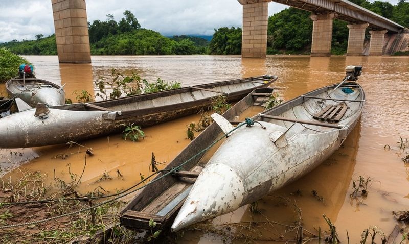
Boats made from bomb casings seen in a village in Laos.

A major cause of casualties, however, is villagers attempting to open the big bombs to sell the metal and the explosives inside to scrap dealers. A high quality bomb casing weighing up to 2,000 pounds can fetch more than $100. Empty bomb casings that once contained deadly explosives are visible all across the country in new forms — from hollowed out canoes and containers, to props holding houses above flood.

When photographer Mark Watson took a bicycle trip across the country, he was surprised to see these lethal devices being reused in extraordinary ways. “Scrap from such widespread bombing has been utilized in people’s homes and villages,” Watson said, “for everything from house foundations to planter boxes to buckets, cups and cowbells.”

Gathering bomb scraps is a deadly occupation, but the people were forced into the trade by poverty.

"Lots of agricultural land is denied to people because of the presence of UXO (unexploded ordnance), and this is the main problem. It prolongs poverty because people can't do what they need to do. If they know that UXO is present, they will not plow deeply enough to get a good quality crop," said David Hayter, of Mines Advisory Group (MAG), an NGO working to detect and remove mines and bombs.

But progress is slow and their budget limited. Meanwhile, people continue to get killed and injured by accidental detonation of live ordnance. As of 2012, at least 29,000 people have died from such accidents.


Children pose near unexploded bombs recovered from around the village.


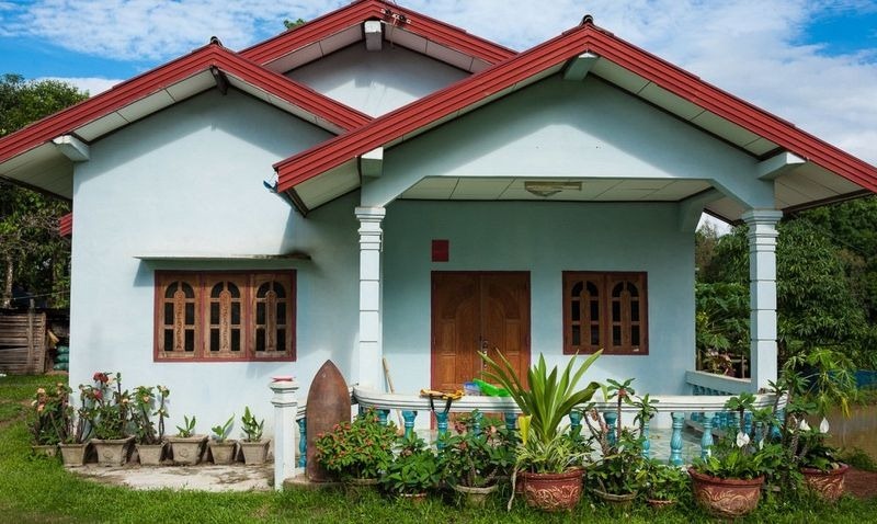
A house in village uses a bomb casing as a garden decoration. 


Bomb casing used as a flower pot. 


Bomb casings used to prop up a house.


Bomb casings as water container. 


Metal recovered from bomb casing shaped into cow bells.


Bomb casings used to prop up houses.


A bomb casing turned into a boat. 


 Source
READ MORE»

Ancient Roman City With a Very Modern Grid Design

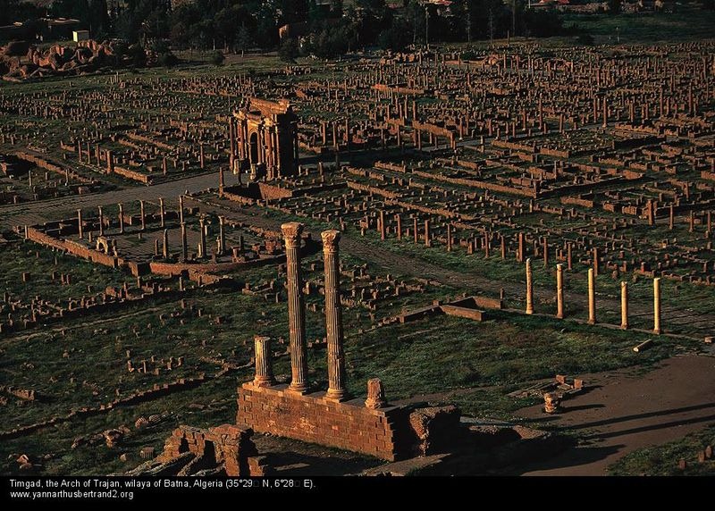
The ruins of Timgad lies on the slopes of the Aures Massif, about 35 km east of the town of Batna, in modern-day Algeria. Built nearly 2,000 years ago, by the Roman Emperor Trajan, the city is laid out in great precision and is one of the best surviving examples of the grid plan used by the ancient Roman city planners.

The city was originally founded as a military colony by the emperor Trajan around AD 100, intended to serve as a bastion against the Berbers in the nearby Aures Mountains. It’s original residents were largely Parthian veterans of the Roman army who were granted lands in return for years of service.


The city’s original design was a perfect square, 355 meters long on each side, with an orthogonal design highlighted by the decumanus maximus (east-west-oriented street) and the cardo (north–south-oriented street) lined by a partially restored Corinthian colonnade. The plan was to provide space for 15,000 residents, but the city quickly outgrew that number and spilled beyond the orthogonal grid in a more loosely but organized fashion. The city grew for the next 300 years as new quarters were added to the original ground plan leading to a quadrupling of the original size.

During its second and third century, the city enjoyed a peaceful existence. Perfectly located at the head of the Oued el-Abiod and a crucial junction, it gave Romans control of one of the main passes through the Aurès Mountains, and therefore of access to and from the Sahara. Starting from the 3rd century, it became a center of Christian activity, and a Donatist center in the 4th century. Timgad fell into decline after the Vandal invasion in the 5th century and the subsequent sacking by Berbers.

The city was revived in the 6th century under the Byzantine Emperor Justinian. A fortress was built outside the original town and many blocks from earlier Roman buildings were reused. But the city fell once again to an Arab invasion in the 7th century. The site was finally abandoned in the 8th century. The city was forgotten until it was excavated from under the sand in 1881.

All these centuries lying under the sand of the Sahara, Timgad remained exceptionally well preserved. At the west end of the decumanus maximus still stands a 12-meters-high triumphal arch, called the Arch of Trajan, which was partially restored in 1900. There a temple dedicated to Jupiter that is of approximately the same dimensions as the Pantheon in Rome. A large Byzantine citadel stands to the southeast of the city. There is also a 3,500-seat theater in good condition, a library, a basilica and four public bath houses.


Source
READ MORE»

Top 7 Highest Cities in the World

Like the microscopic bacteria, human beings too have learned to evolve and flourish in extreme conditions – from the scorching heat of the Sahara to the freezing tundra of Siberia. Even in inhospitable, high mountains where life supporting oxygen is low, humans have been living for millennia. Some 140 million people live permanently at high altitudes above 2,500 meters or 8,200 feet, in the Himalayas in Asia, the Andes in South America and in the Ethiopian Highlands of Africa, and some actually prosper in sprawling cities. Here we present 7 very high cities and settlements, each of which is located above 10,000 feet in elevation.
La Rinconada

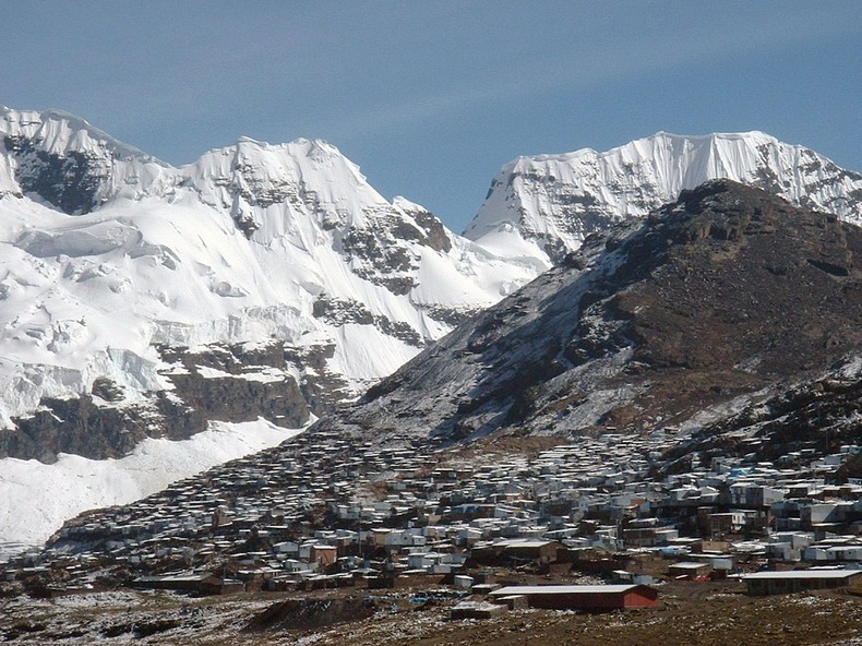
La Rinconada in Peru is an old gold-mining camp in the remote Peruvian Andes, that has grown to ‘major city’ status. Over 50,000 people live in this mountainous city at an altitude of 16,732 feet (5,100 m). It lays claim to the title of “highest city in the world.”


Despite having an economy fueled almost entirely by the nearby gold mine, the town’s infrastructure remains poor. The city has no plumbing and no sanitation system, and there is significant contamination with mercury due to the mining practices.

Almost all the residents of this city are workers who emigrated to the remote location hoping to secure work and stake their claim in the riches. They work through a peculiar system of payment called Cachorreo. Employees work for 30 days without payment, and on the 31st day they are allowed to take as much ore from the mine as they can carry. Whatever the miners are able to extract from that ore is theirs. Despite the companies utilizing such a non-traditional system of payment, miners continue to flock to the region. The population of La Rinconada has skyrocketed over 230% in the last decade.


El Alto
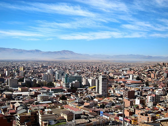
The city of El Alto is one of Bolivia's largest and fastest-growing urban centers. With a population of over 1.1 million at an altitude of 13,615 feet (4150 meters), it is also one of the highest major cities in the world. At one time, El Alto was merely a suburb of the adjacent La Paz on the Altiplano highlands, but due to the migration from Bolivia's rural areas to the La Paz region during the 1950s, the region grew and in less than 40 years laid claim to “city status” of its own.

The region where El Alto stands is dry and inclement and was therefore uninhabited until 1903, when the newly built railways from Lake Titicaca and Arica reached the rim of the canyon, where the La Paz terminus, railyards and depots were built along with a settlement of railway workers. In 1925 the airfield was built as base for the new air force which attracted additional settlement. In 1939 El Alto's first elementary school opened. El Alto started to grow tremendously in the 1950s, when the settlement was connected to La Paz' water supply. Before that all water had to be transported from La Paz in tanker vehicles. 1985 the district of El Alto and surroundings was politically separated from the City of La Paz and in 1987 El Alto was formally incorporated as a city.


Potosi
Another candidate from Bolivia, Potosi, is located at an elevation of 13,420 ft (4,090 m). Founded in 1545 as a mining town, it soon produced fabulous wealth, becoming one of the largest cities in the Americas and the world, with a population exceeding 240,000 people. Potosi lies at the foot of the Cerro de PotosĂ­ - a mountain popularly conceived of as being made of silver ore, whose peak at 4,824 meters has always dominated the city. The Cerro Rico is the reason for PotosĂ­'s historical importance, since it was the major supply of silver for Spain during the period of the New World Spanish Empire.

It is from PotosĂ­, that most of the silver shipped through the Spanish Main came. During 1556 to 1783, 45,000 short tons of pure silver were mined from Cerro Rico of which 9,000 short tons went to the Spanish monarchy. Due to such extensive mining, the mountain itself has diminished in height by a few hundred meters.

In 1672, a mint was established to coin silver and water reservoirs were built to fulfill the growing population's needs. At that time more than eighty-six churches were built and the city's population increased to nearly 200,000, making it one of the largest and wealthiest cities in the world. After 1800, the silver mines were depleted, making tin the main product. This eventually led to a slow economic decline. Nevertheless, the mountain continues to be mined for silver to this day. Due to poor worker conditions, lack of protective equipment and constant inhalation of dust, the miners still have a short life expectancy with most of them contracting silicosis and dying around 40 years of age.


Shigatse
Shigatse is the second largest city in the Tibet Autonomous Region (TAR) of the People's Republic of China. With a population of 100,000, it is one of the larger cities of Tibet. The city is located at an altitude of 12,600 ft (3,840 metres) at the confluence of the Yarlung Tsangpo (aka Brahmaputra) river and the Nyang River (Nyang Chu or Nyanchue) in west Tibet. Shigatse lies on flat terrain surrounded by high mountains, and the urban area is located just south of the Yarlung Zangbo River, located in the south-central Tibet Autonomous Region. The city was the ancient capital of Ăœ-Tsang province, and currently is the administrative centre of the modern Shigatse Prefecture, an administrative district of the TAR.


Juliaca
Juliaca is San Roman's capital city in the Puno Region, of southeastern Peru. It is the region's largest city with a population of 225,146 inhabitants (as of 2007) and located at 12,549 ft (3,825 metres) above sea level, on the Collao Plateau. It is the largest trade center in the Puno region. It is also a major transit point in the region and has strong ties with Peru's southern cities, including Arequipa, Puno, Tacna, Cuzco, Ilo, and with the Bolivian Republic.


Oruro
Founded on November 1, 1606 as a silver mining center in the Urus region, Oruro is now a major city in Bolivia with a population of 235,393 (2010 census), located at 12,159 ft (3,706 m) above sea level. After the silver mines exhausted, Oruro was reestablished in the late nineteenth century as a tin mining center. For a time, Oruro’s La Salvadora tin mine was the most important source of tin in the world. Gradually, this resource became less plentiful, and Oruro again went into a decline, although its primary employer is still the mining industry.


Lhasa
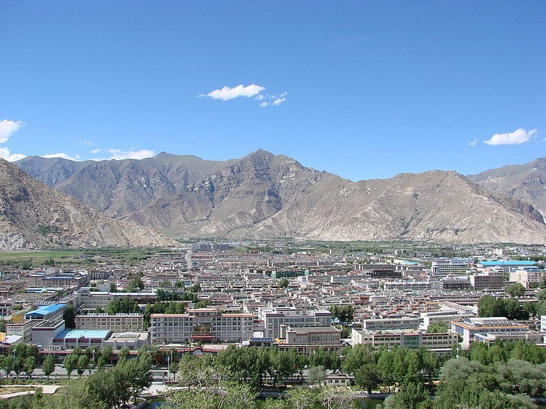
Located at the bottom of a small basin surrounded by the Himalaya Mountains, Lhasa has an elevation of about 11,800 ft (3,600 m) and lies in the center of the Tibetan Plateau with the surrounding mountains rising to 5,500 m (18,000 ft). The Kyi River (or Kyi Chu), a tributary of the Yarlung Zangbo River, runs through the southern part of the city. This river, known to local Tibetans as the "merry blue waves", flows through the snow-covered peaks and gullies of the NyainqĂªntanglha mountains, extending 315 km (196 mi), and emptying into the Yarlung Zangbo River at QĂ¼xĂ¼, forms an area of great scenic beauty.

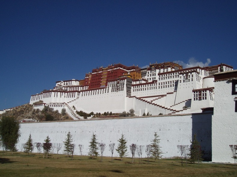
Lhasa is the second most populous city on the Tibetan Plateau having a population of over 550,000. The city contains many culturally significant Tibetan Buddhist sites such as the Potala Palace, Jokhang temple and Norbulingka palaces, many of which are located in Chengguan District, the city seat.


A satellite image shows the mountainous terrain surrounding Lhasa. 


The famous Potala Palace.


Source:
READ MORE»