Whittier Tunnel Alaska

This unassuming slanted roof, house-like structure at the foot of the mountain may appear like a private residence or perhaps a garage, but really is the entrance to the second longest highway tunnel and longest combined rail and highway tunnel in North America. Located fifty miles southeast of Anchorage, near Portage Glacier, in the U.S. state of Alaska, the Anton Anderson Memorial Tunnel, also referred to simply as the Whittier Tunnel, connects the port city of Whittier on Prince William Sound to the Seward Highway. The 4,100 meter-long tunnel passes wholly under Maynard Mountain. It was built during the second World War, at the cost of $80 million, and is the first tunnel in the U.S. that allows automobiles to drive directly over the track area - a design that saved tens of millions of dollars compared to what would have cost if the tunnel was widened to allow the roadway to be separated from the track. The tunnel was named after Anton Anderson, an engineer for the United States army who played a principal role in the construction of the tunnel.


A vehicle enters the Anton Anderson Memorial Tunnel, North America’s longest combined rail-highway tunnel.

Whittier Tunnel is just 16 feet wide and has a single lane shared by both rails and cars. Rail and road traffic are coordinated by two sophisticated computer-based systems which control the timing of vehicles entering the tunnel, spacing them for safety, and lower railroad gates when a train is approaching. Cars heading to Whittier are allowed every half hour while cars leaving Whittier can enter the tunnel every hour. In between regularly scheduled passenger trains are also accommodated.

The tunnel interior is exposed to the natural rock - only portions of the tunnel are lined with concrete and steel. The majority of the tunnel has a wire mesh attached to the ceiling to catch any loose rocks that could work out over time. Inside the tunnel there are several "safe-houses", which are small buildings that are used in case of severe earthquakes, vehicle fires, or other emergencies. The tunnel also contains several turnaround spots, which are reserved for disabled vehicles.

Fresh air is pumped into the tunnel using a combination of conventional portal fans and reversible jet fans which look like pretty much like aircraft jet engines.

The tunnel's entrance portals are designed in an A-shape, with a large, train-sized "garage door", which allows traffic in and out of the tunnel. As many as 450 vehicles can wait outside for passing through.


A southbound train exits the Anton Anderson Memorial Tunnel. Northbound vehicular traffic can be seen lining up, waiting its turn to head back through the tunnel toward the Seward Highway.


The 2.5 mile long tunnel has eight safe houses, which can provide refuge during an emergency.


Tunnel control operator Daniel Gutierrez monitors traffic from 60 video cameras at the tunnel control center on Thursday, June 19, 2014. All tunnel operators are also firefighters trained to respond to an accident inside the 2.5 mile long tunnel.


Source
READ MORE»

Petroglyph Beach

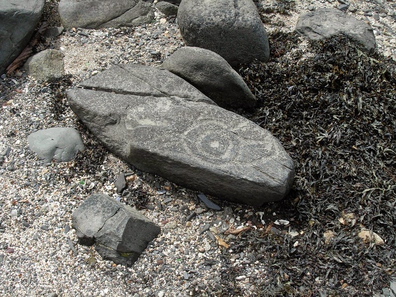
Petroglyph Beach is located on the north-west of Wrangell, a town in Alaska. The beach is so called for the large number of petroglyphs resembling eyes, totemic animals and geometric patterns that have been found carved into boulders and the bedrock on this site. These petroglyph are at least 8,000 years old, although their exact dates are uncertain.

The petroglyphs in Wrangell are found scattered near the shore just below the mean water line, revealing themselves during periods of low tide. Most of the petroglyphs can be found close to places of importance such as salmon streams and sites of habitation. Some 40 petroglyphs have been discovered till date, making Petroglyph Beach the site of the highest concentration of petroglyphs found in Southeast Alaska. Since 2000, the beach is a State Historic Park.


The fact that most petroglyphs are found on the beach in a narrow band at the mid-tide mark indicates that they were created when the sea level was lower. The ice melted in this region some twelve thousand years ago and sea levels began to rise. So, the earliest petroglyphs may be many thousands of years old, carved at a time of lower sea levels.

It is generally believed that the petroglyphs were created by the ancestors of the present day Tlingit tribe because of the similarity in the symbols and the artistic style used in the petroglyphs with those found in historic and current Tlingit totemic art. Many of these carvings depict whales, salmon, and faces of the community.

As the petroglyphs were mainly located near the mouths of salmon streams and could only be seen from the sea side, these petroglyphs could be a way to invoke the gods to send salmons for spawning every year which they hunted for food, or perhaps a thank-you to the gods for bountiful hunts. Another possibility is that the designs could serve as territorial markers for a good hunting area or ownership of fishing ground.

The rock here is metamorphic and tends to be a dark gray that is finely grained, moderately hard and durable, and easy to fracture, which would make it easier to carve. But that also makes the rocks prone to damage. Hence touching or walking on the rocks is prohibited. There is an accessible boardwalk to a deck overlooking Petroglyph Beach. On the deck replicas of several designs are displayed for visitors to make rubbings on.


Source
READ MORE»

Frost Flowers

It is as beautiful as it is rare. A frost flower is created on autumn or early winter mornings when ice in extremely thin layers is pushed out from the stems of plants or occasionally wood. This extrusion creates wonderful patterns which curl and fold into gorgeous frozen petioles giving this phenomenon both its name and its appearance.

Conditions have to be just so for frost flowers to form. Early winter and late autumn are the optimum time to come across them as although the weather conditions must be freezing it is vital that the ground is not.


As the temperature gets to freezing or below the sap in the stem of the plants will expand. As it does so the outer layer of the stem comes under increasing pressure and microscopically thin cracks, known as linear fissures, begin to form. These will finally give way under the pressure of the sap and split open.


Water is continuously being drawn up the plant’s stem while the ground remains unfrozen. It travels up the plants external structural axis (stem!) and reaches the split or splits. As it does so, it oozes slowly out and it freezes. Yet more water is coming behind it.


This new water reaches the cracks and it too freezes, pushing the previous slither of ice away from the stem. In this manner the amazing ‘petals’ that you see in these pictures are formed.


Incredibly, the frost flower effect can happen to wood even when it has been made in to a fence or a gate, as seen above. In this case the water is extruded through the pores in the wood rather than cracks.


The frost flower has a number of other names: you may know them as frost castles, ice castles, ice blossoms, or even the very scientific sounding crystallofolia. Yet the name is something of a misnomer: frost is created by water vapor. Frost flower, on the other hand, are formed from liquid water.


If you come across one – be careful! Rather than attempt to pick it up, if you have a camera or a phone with you take a picture instead. Frost flowers are incredibly delicate and will more often than not shatter when touched.


Source
READ MORE»

The Highest Unclimbed Mountain in the World

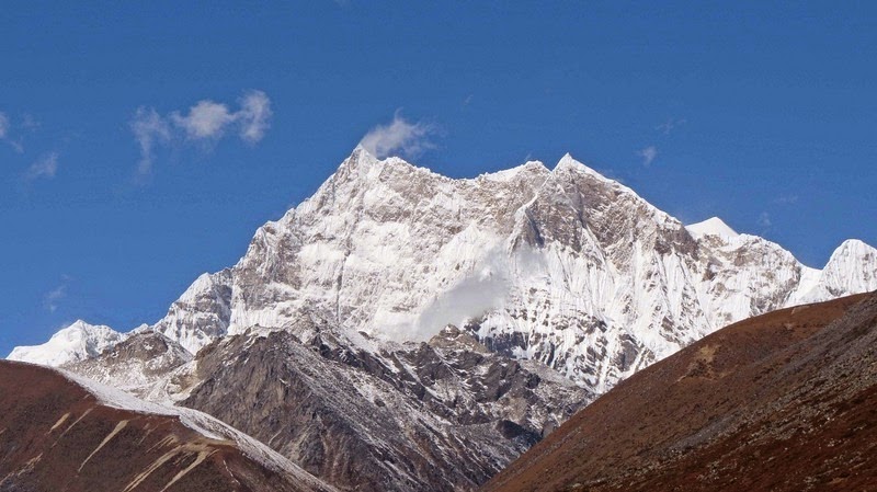
Gangkhar Puensum is the highest mountain in Bhutan, and at 7,570 meters, it is the 40th highest peak in the world. As surprising as it may sound, Gangkhar Puensum still remains unclimbed, especially when most peaks in the Himalaya have already been scaled decades ago.

Gangkhar Puensum lies on the border of Bhutan and Tibet, although the exact boundary line is disputed. Chinese maps put the peak squarely on the border whereas other sources put it wholly in Bhutan. When the mountain was first mapped and surveyed in 1922, maps of the region were shockingly inaccurate. Until very recently, maps of the region showed the mountain at different locations and marked with different heights. In fact, one of the first team to attempt the summit was unable to find the mountain at all.


Bhutan opened itself up to mountaineering only in 1983, as they believed that towering mountains were the dwelling of spirits. When Bhutan finally opened its doors to mountaineering, a series of expeditions were organized. Between 1985 and 1986, four attempts were made, but all ended in failure. The decision to allow mountaineering as a commercial pursuit didn’t last long. In 1994, the government forbade climbing of mountains higher than 6,000 metres out of respect for local spiritual beliefs, and since 2004 mountaineering in the country has been banned completely.

In 1998, a Japanese expedition acquired permission from the Chinese Mountaineering Association to climb Gangkhar Puensum north of Bhutan from the Tibetan side. But a longstanding border dispute with Bhutan, finally caused the permit to be revoked. Instead, the expedition settled for a previously unclimbed 7,535-meter subsidiary peak of Gangkhar Puensum called Gangkhar Puensum North, also known as Liankang Kangri. Notes taken by the team suggested that the expedition to the main summit would have been successful if allowed. Curiously, unlike other maps the expedition's report shows Gangkhar Puensum as being in Tibet, rather than Bhutan, and the Tibet–Bhutan border is shown crossing the summit.

Bhutan itself has not surveyed the peak yet, and it appears that the country has no interest in doing it any time soon. With the difficulty of securing permits from the government as well as lack of rescue support, it seems that the mountain will likely remain unclimbed for the foreseeable future.


The location of Gangkhar Puensum shown by the marker “A” on the Bhutan-Tibet border.


Gangkhar Puensum from Ura valley, Bhutan.


The approach to Gangkhar Puensum.


Source
READ MORE»

The Island Where Everyone is Related

Palmerston Island is a coral atoll in the Cook Islands in one of the most isolated part of the Pacific Ocean, about 3,200 km from New Zealand. The tiny Pacific island has no airport, and is visited by a supply ship only twice a year. The journey to the island is so long and hazardous that only the most intrepid visitors ever dares to visit it. But Palmerston’s fame comes not only from the fact it is a perfect island paradise, but from its unique history.

Palmerston Atoll is made up of a number of sandy islets on a continuous ring of coral reef enclosing a lagoon. Six of them are of significant size including Palmerston, North Island, Lee To Us, Leicester, Primrose, Toms, and Cooks, that together cover just 1 square mile (2.6 km2) in area. The atoll is 11 km across and 15 km from north to south that encloses an area of 56 square kilometers of sea.


The first person to set foot on Palmerston was Captain Cook in 1777, although he had discovered the island three years earlier on another trip. Cook named the island after Henry Temple, 2nd Viscount Palmerston, then Lord of the Admiralty. The island remained largely uninhabited for almost another century when it was chanced upon by William Marsters, a carpenter and barrel maker of a whaling ship that frequented the Bay of Islands, in 1860. William Marsters was so charmed by the island that three years later he returned with a wife, the daughter of the chief of another Cook island, and her two cousins with the intention of permanently settlement on the island.

The atoll was uninhabited at the time, and Marsters used wood salvaged from shipwrecks to build and populate a tiny community, which soon included a church, school room and homes. Marsters, together with the three women, had 17 children whose descendants make up the present population of Palmerston. Today, Palmerston has 62 inhabitants, all but three are descended from William Marsters.

Before he died William Marsters, organized the island so that each of the three wives and their descendants had a share of the main island and each of the atolls. This arrangement still stands. Today the Island has its own Council, representing the local government, and members of the three family. Marriage within a family group is prohibited.

Palmerston Islanders still pride themselves on their British heritage – they fly the British flag on special occasions, have large photos of the Queen in their homes, and remember fondly the visits of the Royal Yacht Britannia. Although it is administered by the Cook Islands government under the jurisdiction of New Zealand, in 1954 the family was granted full ownership of the island.

Life on Palmerston is simple. There are no shop, just two toilets, and rainwater is collected for drinking water. Money is only used to buy supplies from the outside world not from each other. Electricity runs from 6am – 12pm each day and again at night. A recently built telephone station provides the only permanent link to the outside world. Fish is the islanders' staple food and their only export. One or two tons of parrot fish are frozen and collected by the supply ship which comes twice a year to deliver essential supplies such as rice and fuel.

Aside from the cargo ships, the island sees about a dozen visiting boats a year bringing tourists. Since there are no resorts or hotels, by custom, the family that first greets the visitors offer them a homestay at their house.


Islanders: William Marsters and his brood.


Willima Marsters’ gravestone.


Satellite telephone and solar panels.


Source
READ MORE»