Passage du Gois

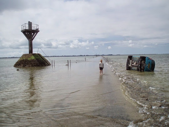
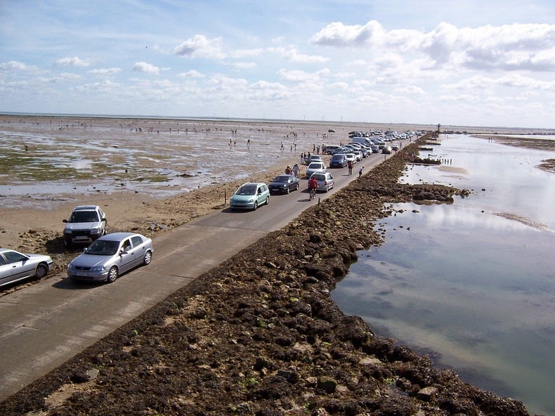
Passage du Gois is a submersible causeway in the Bay of Bourgneuf, linking the island of Noirmoutier to the mainland in the department of Vendée, in France. Twice a day, for an hour or two, the tide goes out and the causeway becomes visible and accessible to traffic. For the rest of the day, it remains flooded under 1.3 to 4 meters of water and cannot be used.

Although causeways such as Passage du Gois exist in other places (there is one in the county of Jindo in Korea), the uniqueness of Passage du Gois lies in its exceptional length - 4.5 km. In the 18th century, the causeway was much longer because the old dikes were farther from the coast.


In the early days, the only way to reach Noirmoutier was by boat. Then the Bay of Bourgneuf gradually silted up and the causeway was formed allowing men and animals to wade through the waters to the island. In fact, the name “Gois” comes from the verb "goiser" which means to walk while wetting one’s shoes. It was in 1701 that the passage connecting the mainland to the island was first mentioned on a map.

This curiosity has existed since the collapse of the plateau which gave birth to the bay of Bourgneuf. Over a thousand years, the two currents from the north and south hitting the bay has resulted in deposition of silt, and that has continually moved before stabilizing, about a century ago to the current location. Later, stabilization work was done to prevent sand from moving and a cobblestone road was laid down. Around 1840, a regular service was provided by car or on horseback. In 1971, a bridge linking the island to the mainland was built as an alternative route to the island of Noirmoutier.


Crossing the causeway is considered perilous. Although tide times are precisely marked on either side of the causeway on large signs, the water comes in at an incredible rate and many visitors get caught out every year. Elevated rescue towers are located all along the Passage du Gois for those caught between the tides. One can climb these towers and wait until they are rescued or the tide falls again.

During low tide, hundreds of tourists and locals alike come to walk, cycle or drive across the Gois. The causeway also attracts a lot of shell seekers looking for edible shells on the exposed sand, especially at low spring tides when the vast expanses of sand which are rich in all manner of shell fish are exposed.

Since 1986, an unusual race across the causeway – the Foulées du Gois – is held every year. In 1999 Passage du Gois was also used by Tour de France bicycle race.




Foulées du Gois 2013, the annual race
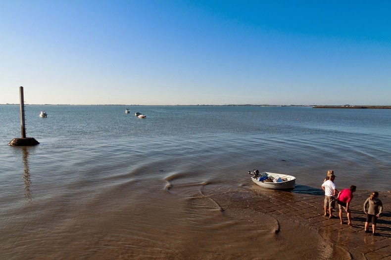

Looking for shells.
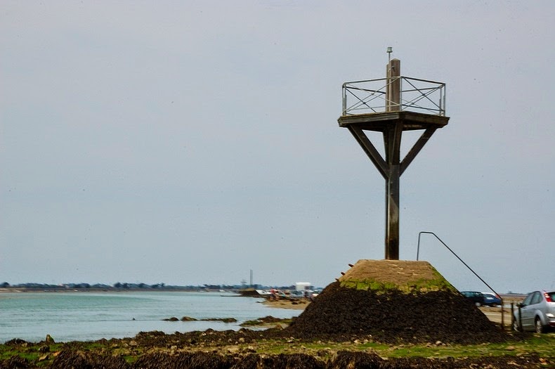

One of the several rescue towers along the Passage du Gois.


Source
READ MORE»

Gaiola - The Cursed Island

Gaiola Island (Isola della Gaiola in Italian) is one of the minor islands of Naples, Italy, located in the Gulf of Naples in the heart of Gaiola Underwater Park, a protected region of about 42 hectares. The island consist of two stunning and serene islets. Located on the southern border of Posillipo and very near to the coastline – about 30 meters away, the island is easy to reach. While one of the islet has a solitary villa, the other is uninhabited. A small bridge connects the two islets, which are separated by just a few meters. The bridge is very narrow and looks like a natural arch connecting the two islets.

The island takes its name from the cavities that dot the coast of Posillipo, originating from the Latin cavea, "little cave", and then through the dialect "Caviola". Originally, the small island was known as Euplea, protector of safe navigation, and was the site of a small temple dedicated to Venus. There are also several other ruins from the time of the Romans. In fact, below the islets in the water are several Roman structures that are now the home of marine creatures. Some believe that the poet Virgil, regarded as a magician, taught here at the ruins.


In early 19th century, the island was inhabited by a hermit known as "The Wizard". Soon after, the island saw the construction of the villa that occupies it today and which was, at one time, owned by Norman Douglas, author of Land of the Siren. The island might seem as a perfect post-retirement getaway, however, the locals believe the island to be cursed, a reputation that came about because of the frequent premature death of its owners.

The series of misfortunes started sometime around the 1920s, when the then owner, a Swiss named Hans Braun, was found murdered and wrapped in a rug. A short while later his wife drowned in the sea. The villa’s next owner was the German Otto Grunback, who died of a heart attack while on the island. A similar fate befell the pharmaceutical industrialist Maurice-Yves Sandoz, who committed suicide in a mental hospital in Switzerland. Its subsequent owner, a German steel industrialist, Baron Karl Paul Langheim, was dragged to economic ruin by wild living. The island has also belonged to Gianni Agnelli, the head of Fiat, whose only son committed suicide. After his son's untimely death Gianni had started grooming his nephew Umberto Agnelli to run Fiat, but Umberto also died of some rare cancer at the young age of 33. Another owner, the multi-billionaire Paul Getty, after buying the island, had his grandson kidnapped. The island’s last owner Gianpasquale Grappone was jailed when his insurance company failed. Today, the villa is uninhabited and abandoned.


Source
READ MORE»

A Creek That Flows Into Two Oceans

Within the Teton Wilderness area of Bridger-Teton National Forest, in Wyoming, USA, lies a very unremarkable creek with a remarkable hydrological phenomenon. At the Two Ocean Pass, a mountain pass on the continental divide, the creek abruptly splits into the separate streams; one goes off to the left and the other to the right. Each stream keeps going, joined by larger and larger streams, and eventually reach the oceans. The stream to the left, called the Atlantic Creek, travels 5,613 km, joining up with the waters of the Mississippi river and winding up in the Atlantic Ocean. The stream to the right, called the Pacific Creek, undertakes a 2,177 km trip joining up with the Snake and Columbia Rivers and empties into the Pacific Ocean. Aptly named the Two Ocean Creek, it’s the only one in the United States that breaks and ends up in two different oceans. The point where the bifurcation occurs is called “Parting of the Waters”, and it sits directly atop the Continental Divide.


Technically, it’s possible for a fish to make the nearly 10,000 km freshwater journey from the Pacific Ocean to the Atlantic Ocean via the Two Ocean Creek. In fact, it is believed that this was how the cutthroat trout migrated from the Snake River (on the Pacific drainage) to Yellowstone River (on the Atlantic drainage).

This site received designation as a National Natural Landmark in 1965, bearing the official name of Two Ocean Pass National Natural Landmark. Parting of the Waters is located about 640 meters northwest of the low point of Two Ocean Pass, where North Two Ocean Creek emerges from its drainage basin on the side of Two Ocean Plateau.


Source
READ MORE»

Mocona Falls - A Waterfalls That Run Parallel to the River

Iguazu Falls may be the most popular waterfalls in Argentina, but Mocona Falls take the crown for the most unique. Mocona does not follow the normal downward and forward trajectory that most waterfalls do. Instead, it runs along the length of the river with water spilling off the side into a gorge. At 3 km long, it is perhaps the only waterfalls in the world to run parallel to the river rather than perpendicular.

Mocona Falls, also known as Yucumã Falls, is located in the Uruguay river, in the province of Misiones, in Argentina, 337 kilometers from the city of Posadas and 322 kilometers from Iguazu Falls. Since the Uruguay river acts as a natural border between Argentina and Brazil, this unique geological feature is shared by both countries. The name Moconá means “to swallow everything” in the Guarani language and is used mostly in Argentina. Yucumã means “the big fall” and is popular in Brazil.


An unusual feature of the Uruguay River is the presence of a submerged canyon or trench at the bottom of the river channel. The canyon, which is believed to have formed during the Ice Age, when the climate was drier and the river was narrower, is up to 100 meters deep and 15 - 30% of the width of the river. The canyon is only visible in two places, one of which is the Moconá Falls.

The falls itself are not visible for 150 days a year when the river is full. During this period, the falls become more like rapids. When water level becomes low and falls below the edge of the canyon, it starts spilling into the now exposed canyon, and the Mocona Falls is formed. Depending on the volume of the water dragged by the Uruguay River, the height of the falls varies from five to seven meters. The width of the waterfall is also subjected to water volume ranging between 1,800 meters and 3,000 meters wide.

The area where the Moconá falls are located is considered a Provincial Park which include the Yabotí Biosphere Reserve. Countless lodges have been settled down in the area which provide accommodation for visitors in search of water activities such as rubber boat rafting, canoe outings, kayaking and safaris along the river and creeks around this wetland.


Source
READ MORE»

Grassholm - The Guano Covered Island

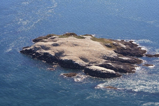
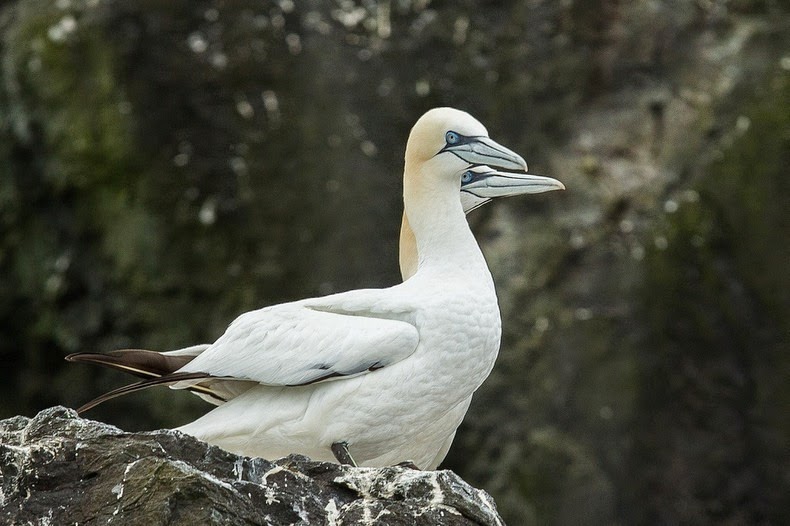
Grassholm is a small uninhabited island, just 200 meters across, located 13 kilometers off the southwestern Pembrokeshire coast in Wales. This tiny island is home to one of the largest colonies of gannets. During the breeding season, from April to September, some 39,000 pairs of birds, accounting to 10% of the world’s population, nest on the northern side of the island. Consequently, this side of the island is covered with a thick layer of bird droppings, also known as guano, giving the island its characteristic off-white color. From afar, the island looks very much like a bun sitting on the ocean with icing sugar on top. As you approaches the island by boat, the stench becomes overbearing.


The white patch on the island that can be seen from above and off-shore, is neither snow nor limestone rock. It’s the birds themselves and their shit.

Grassholm is made up of basalt, an igneous rock of volcanic origin. It’s believed that the island was once a part of Skomer Island before it got loose during the last Ice Age.

During the late 16th century Puffins inhabited the island in tens of thousands, however, now there are none. The current soil condition doesn’t support burrows that these birds make, which is perhaps why they moved to the nearby Skomer and Skokholm Islands. Gannets have now colonized the island in huge numbers, probably arriving from Lundy island where they were disturbed. Grassholm covers only 22 acres and there are at least 80,000 Gannets plus their chicks, as well as small colonies of Guillemots, Razorbills, Kittiwakes and Shags.

The gannets were first mentioned on the island in 1860 and in 1872, 12 pairs where recorded as breeding there. By the 1890's there were 200 or more and in 1905 Cardiff Naturalists Society recorded 300 breeding pairs. Gannet population has been steadily increasing since.

The bird live in very close proximity to each other and have evolved a series of vocal and postural messages. There are always thousands of gannets in the air above the island dive fishing from all angles and from great heights. The cacophony of sounds they make is deafening.

Interestingly, the guano had killed the dense mattress of grass in this island exposing archaeological remains of settlements from the Iron Age and early Medieval periods.


Source
READ MORE»