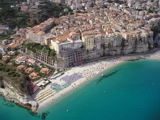
Tropea - The Cliffside Town

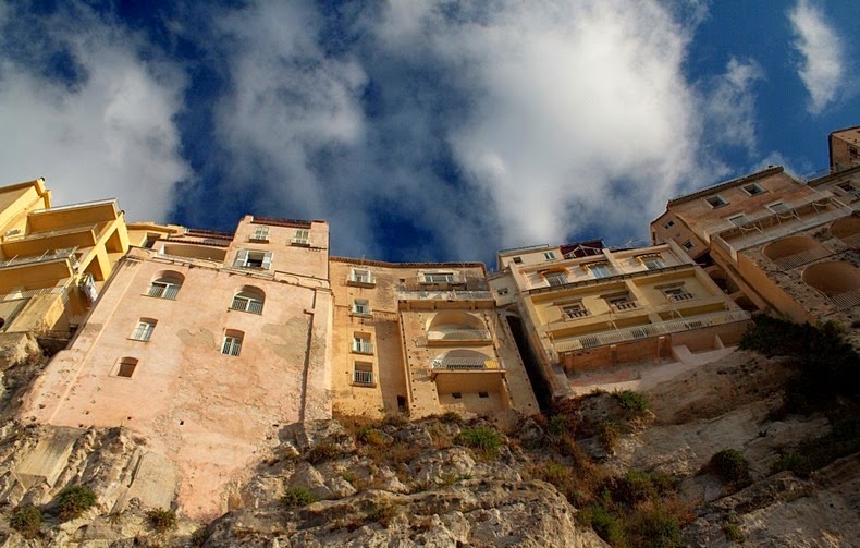
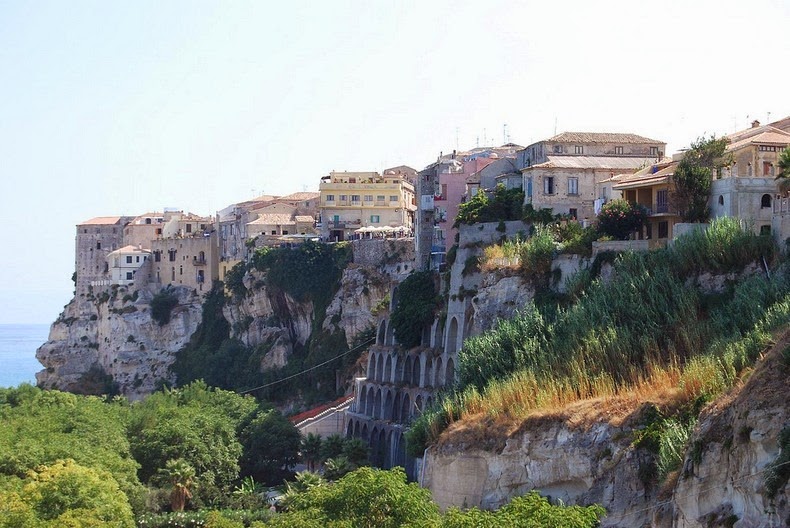
Tropea is a seaside resort located in the region of Calabria, in the south of Italy. The town is perched on top of an imposing cliff, in the gulf of St. Euphemia which is connected with the mainland by a narrow strip in the Tyrrhenian Sea. This stretch of coastline on the Tyrrhenian Sea is called the Costa degli Dei – the “Coast of the Gods”, and is one of Italy’s finest summer holiday destinations. With dramatic cliffs overlooking a crystal clear blue sea and sunny beaches, Tropea is a famous bathing place. Although it is not particularly well-known to English-speaking travellers, Tropea is popular with Italians.

The town is a puzzling maze of pretty little lanes and piazzas. The cobbled streets are lined with old buildings made from golden stone and at various points, flights of stairs descend down to the beaches below. On a clear day you can easily see the volcanic island of Stromboli from the waterfront promenade and it is possible to book a boat trip over there for the day.


The most famous view of Tropea is of the large rock outcrop jutting into the sea a few hundred meters from the town. At the top is the monastery, Santa Maria dell'Isola, built in the 7th century. Other buildings worth visiting are the beautiful Norman Cathedral and the churches of San Francesco and Santa Maria della Neve. If you explore the streets you'll find traces of the old town wall and fortifications which defended the landward side.

Legend has it that Tropea was founded by Hercules, when he returned after completing one of his 12 labors. Historical records, instead, tells us about the African Publio Scipione, who returning victoriously from the Battle of Zama (202 BC), founded a city and offered it as a trophy of gratitude to the gods for the victory, from which the town took its name. The area was inhabited as far back as Neolithic times, and has been occupied, at various times, by the Arabs, Normans, Swabians, Anjous and Aragonese, as well as being attacked by Turkish pirates.





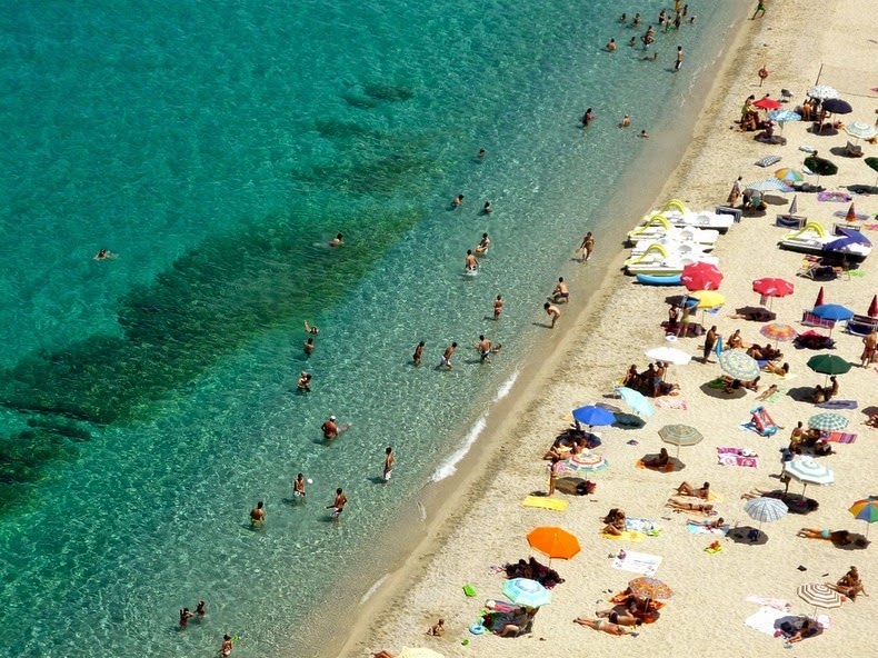


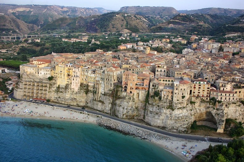


Source
READ MORE»

Mountains of Hornocal

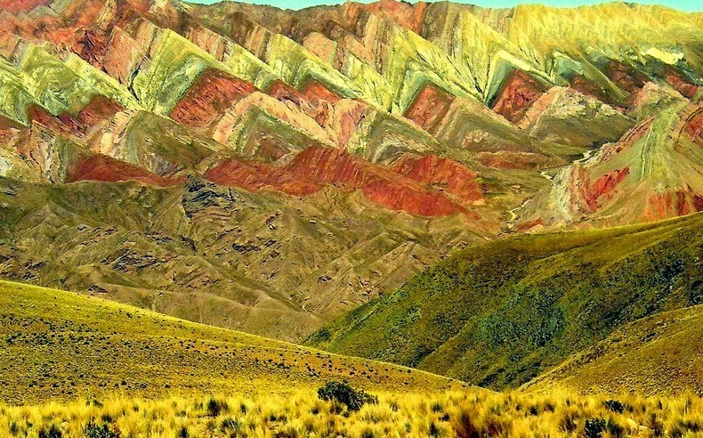
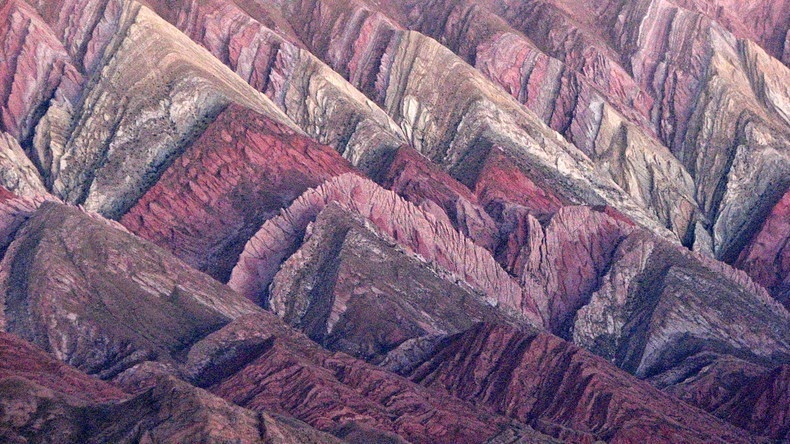
The mountain valley of Quebrada de Humahuaca, in the province of Jujuy, in north-west Argentina, is home to some fascinating geology. The Hill of Seven Colors and Painter's Palette in MaimarĂ¡ are famous, but most visitors leave the creek without knowing the mountains of Hornocal or “Serranias del Hornocal”. Located just 25 km from Humahuaca, along a well-graded unpaved road, this mountain range is definitely a must-see for anyone visiting Argentina, yet quite shockingly, this site left out of almost all the tourist circuits because of which Serranias del Hornocal remains unknown to most travelers on the road that leads to Humahuaca.


The incredible colors and the inverted-V shaped formation seen here is part of the limestone formation called Yacoraite that extends from Peru to Salta, through Bolivia and the Quebrada de Humahuaca. The road that leads to this place, located at an altitude in excess of 4,300 meters, is inaccessible by bus, but can be easily reached by a regular car or a 4x4. Despite warnings of inaccessibility and risks involved, those who travel to this place have discovered that it’s actually a pretty easy route.


Source
READ MORE»

The Red Earth Terraces of Dongchuan

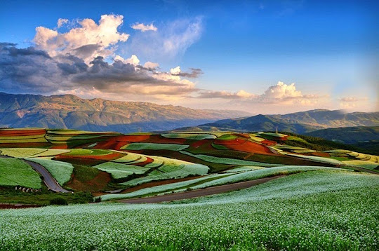
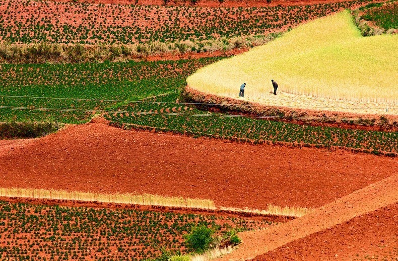
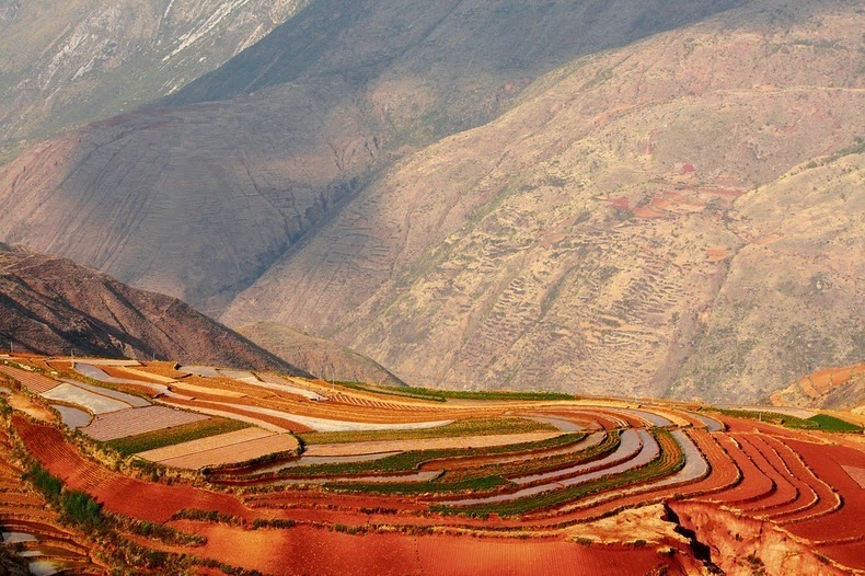
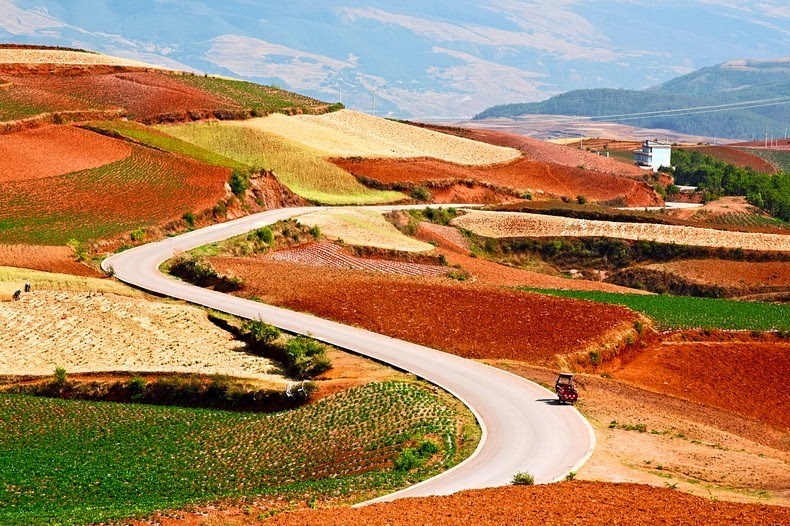
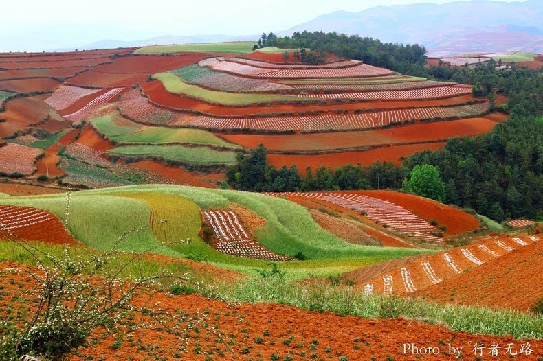
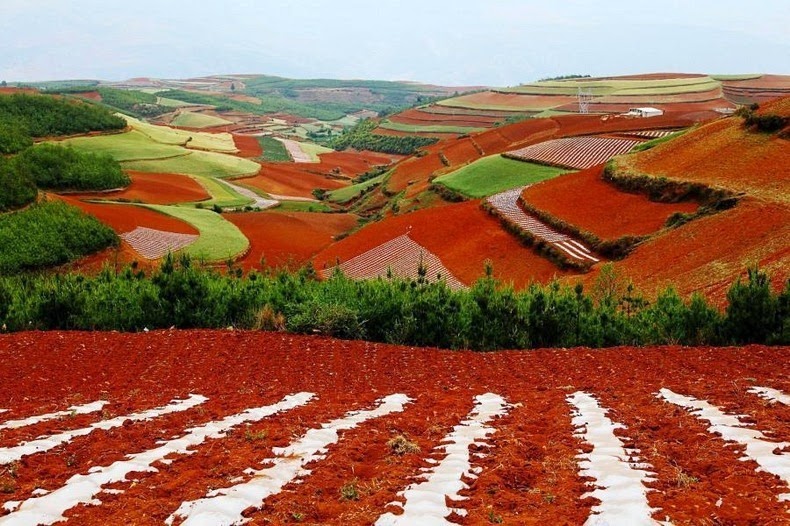
Some 250 kilometers northeast of Kunming, the capital of China's Yunnan Province, lies Dongchuan, a rural area with the world's most imposing red earth. Spread over vast terraced fields, Dongchuan’s unusual brownish-red color comes from its rich deposit of iron and copper. Exposed to the warm and humid climate of Yunnan, the iron in the soil undergoes oxidization to form iron oxide which is naturally red in color. These oxides, deposited through many years, gradually developed into the extraordinary reddish brown soil seen here today. Every year during spring, when this area is ploughed for agriculture, a large number of visitors and photographers come to see squares of freshly upturned red earth waiting to be sown along with areas of budding green plants. The fiery red soil juxtaposed with emerald green barley, and golden yellow buckwheat, against a blue sky produces one of the richest color palate rarely seen in nature.


Reportedly, the existence of Dongchuan was unknown to the outside world until the mid-1990s, when a Chinese photographer chanced upon the place. The story goes that the photographer kept the location a secret and continued to produce photographs that awed his audience. Details about the secret place eventually leaked and now more and more photographers are making arduous trip into the mountains to get first-hand experience of this amazing place.


Source
READ MORE»

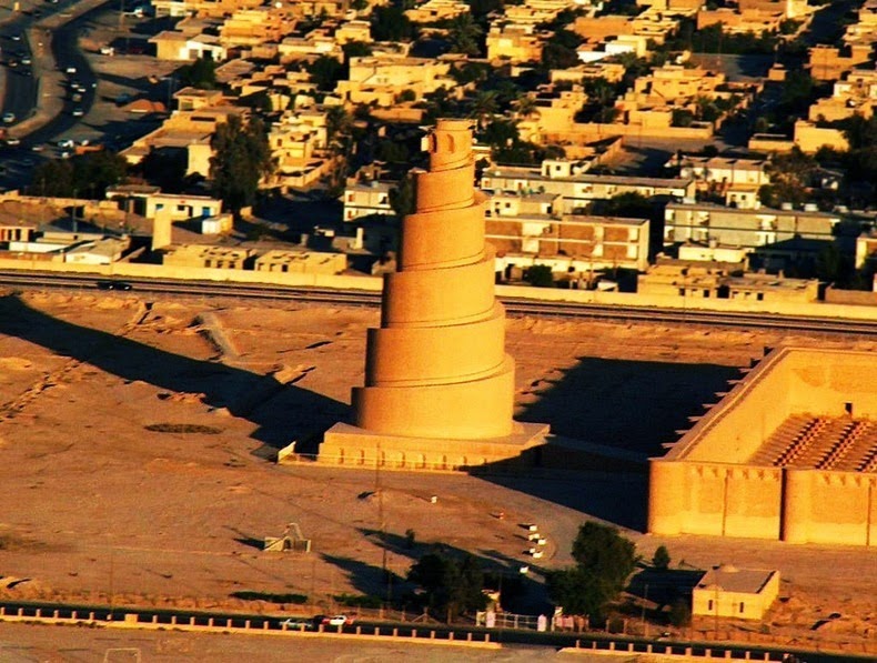
The "Great mosque of al-Mutawakkil" in Samarra

The Great Mosque of Samarra is located in Samarra city, in Iraq, about 120 km north of Baghdad, on the banks of river Tigris. It was built in the 9th century, commissioned by the Abbasid caliph Al-Mutawakkil, who moved to Samarra to escape conflict with the local population in Baghdad and remained there for the next 56 years - a period during which he built many palaces including the largest mosque in all of Islam. The Great Mosque was spread over an area of 17 hectares; the building itself covered 38,000 square meters. It remained the largest mosque in the world for the next 400 years before it was destroyed by the armies of the Mongol ruler Hulagu Khan during the invasion of Iraq in the year 1278. The outer walls and the imposing 52-meters minaret is all that remains of this once Great Mosque.


The mosque has a rectangular layout encompassed by an outer baked brick wall 10 meters high and 2.65 meters thick and supported by a total of 44 semi-circular towers including four corner ones. One could enter the mosque through one of the 16 gates. It has been told that featured over each entrance were several small arched windows. Between each tower, a frieze of sunken square niches with beveled frames runs the upper course of the entire structure. The mosque had 17 aisles, and its walls were paneled with mosaics of dark blue glass. The courtyard was surrounded on all sides by an arcade, the greatest part of which was the one facing Holy Mecca.

27 meters from the center of the mosque's north face stands the Malwiya Tower with its vast spiraling cone 52 meters high and 33 meters wide at the base. At the top of the tower rests a round vestibule, which is adorned with eight pointed-arched niches. It is possible to walk all the way to the top along the spiraling path. As a matter of fact, the caliph Al-Mutawakkil, often did that riding on his donkey to enjoy the view.

The minaret was partially destroyed in April 2005, when insurgents bombed the tower because U.S. troops had been using it as a lookout position. The British claim that the attacked was directed not towards the U.S. but had been done to incite Sunni-Shiite violence and further destabilize the country.


Source
READ MORE»

The New Nazca Lines were Revealed

A pilot flying over the Nazca desert in Peru has discovered huge geoglyphs that are believed to be nearly 2,000 years old -- and may shed new light on the ancient Nazca people.

The "Nazca lines" were apparently exposed by recent sandstorms in the area and include a snakelike figure roughly 200 feet long, a huge zigzag line, and a giant bird.

Pilot and researcher Eduardo HerrĂ¡n GĂ³mez de la Torre, who made the discovery in late July, told the Peruvian newspaper El Comercio that the designs might have been created by the Paracas, a prehistoric culture that ruled southern Peru from around 800 B.C. to 100 B.C., predating the Nazca culture, which ruled the region from 100 B.C. to 800 A.D. The Paracas were known for their exquisite art and textiles.

While scholars contacted by El Comerico said they suspected the geoglyphs were created during the transition period between the Paracas and Nazca cultures, archaeologists still need to confirm the origin of the designs.


Nazca lines blanket about 280 square miles in the coastal plain region of Peru and were created between 500 B.C. and A.D. 500, according to the UNESCO website. Often depicting animals, plants, and geometrical designs, they are believed to have had "ritual astronomical functions." Yet Edward Ranney, a photographer whose forthcoming book, The Lines, centers upon the geoglyphs, suspects the designs may have served a different purpose.

"Though their purpose is not definitively known, [the designs] clearly served a ceremonial purpose, and were continually used and recreated over several centuries, perhaps to honor sacred mountains and sources of water," Ranney said in a recent interview with the art blog PetaPixel. "It was previously thought they were astronomically and calendrically aligned, which could be true in some cases, but now that idea is not widely accepted."

No matter what their function was, the lines continue to capture the imagination of archaeologists. As the UNESCO website puts it, "The Nazca lines and geoglyphs form a unique and magnificent artistic achievement that is unrivaled in its dimensions and diversity anywhere in the prehistoric world."


Source
READ MORE»