Bahia Honda Rail Bridge in Lower Florida Keys

The Bahia Honda Rail Bridge is an abandoned bridge in the lower Florida Keys connecting Bahia Honda Key with Spanish Harbor Key. The bridge was originally built between 1905 and 1912 by billionaire Henry Flagler, who was a partner in Standard Oil with John D. Rockerfeller, as part of the Overseas Railroad. It was intended to carry a single track of the Florida East Coast Railway across the Big Spanish Channel from Bahia Honda Key to Spanish Harbor Key. Due to the channel’s depth, being 24-feet at it’s deepest point, the Bahia Honda Bridge was built with a steel truss construction as apposed to a concrete arch form that was predominate throughout the Overseas Railway.


Building the railroad was a stupendous labor and engineering challenge. The Florida Keys were periodically swept by storms that killed thousands of workers during the construction period. On Labor Day, in 1935, one of the strongest hurricanes on record hit the Florida Keys, damaging the bridge and killing hundreds of WWI veterans working on a WPA bridge project. The overseas railroad came to an end and the bridge was sold to the State of Florida in 1938, who converted it for highway use.

Rather than completely rebuilding the bridge after the hurricane, the existing structure was repaired and the deck for the highway was added on top, as the existing deck inside the truss was too narrow for vehicular traffic. The bridge served as the primary mode of transport to the islands of the lower Keys, and as a primary evacuation route.

When a new four-lane bridge was built in 1980, a few hundred yards north of the old bridge, two spans of the bridge were removed to accommodate boat traffic and make the majority of the bridge inaccessible to pedestrian traffic. While most of the bridge has be abandoned, the easternmost section of the bridge is open to pedestrian traffic and provides a scenic overview of the area.


Source
READ MORE»

CEFAA Chile Releases Official Study on UFO Photos

The government office investigating UFOs in Chile has released an analysis of two high quality photos showing what appear be genuine unidentified flying objects above a remote copper mine. The office, known as the CEFAA (Committee for the Studies of Anomalous Aerial Phenomena), is located within the Ministerial Department of Civil Aeronautics (DGAC), the equivalent of our FAA, under the jurisdiction of the Chilean Air Force. It is responsible for the analysis of selected reports of unexplained aerial phenomena in Chilean airspace, most of them from pilots and aviation personnel.

The photos were taken at the Collahuasi copper mine, more than 14,000 feet above sea level in the Andean plateau in the far north of Chile. An extremely remote location with low oxygen levels and unusually clear skies, the area is desolate and inhospitable. The Collahuasi mine produces copper concentrate, copper cathodes and molybdenum concentrate from three open-pit mineral deposits.

Four technicians - professionals specializing in electricity, electronics, and fluid control - were working there in April, 2013. They witnessed a disc-shaped object which approached slowly and was present for more than an hour, moving around in different positions and hovering at about 2000 feet. One technician took pictures with his Kenox Samsung S860 camera. The strange object made no sound, and eventually moved away towards the East.

The witnesses decided not to tell anybody because of the negative associations they had with UFO sightings, and therefore had every intention of always keeping the sighting private. But some months later, the photographer casually showed the pictures to the chief engineer at the mine, who asked for copies. The engineer sent the images to the CEFAA in February, and provided the agency with information reported to him by the witnesses. He too has requested anonymity.

Chile's meteorological office at the DGAC confirmed that there was an absolute clear sky at that time, and that there was no possibility of lenticular clouds. All other meteorological phenomena have been ruled out by Chilean officials as a possible explanation.

CEFAA officials told me they determined that there were no drones operating near the mine. "People in that zone know about drones," said Jose Lay, international affairs director for the CEFAA. "Fishing companies use drones and they make a lot of noise. This was definitely not a drone." DGAC officials also ruled out any experimental aircraft, planes, weather balloons, or anything else that could explain the incident.

With all conventional explanations eliminated, the CEFAA staff determined that the photos were worthy of analysis. The results of this study, conducted by a leading CEFAA analyst at the DGAC Meteorological Office, was released on July 3rd and is posted on the CEFAA website.

The report states that the witnesses described the phenomenon as "a flattened disc, of brilliant color, with a diameter of 5 to 10 meters [16 to 32 feet]. It performed ascending, descending and horizontal movements in short lengths, about 600 meters above the ground." The witnesses had the impression that the object was under intelligent control.


The first image, enlarged and filtered, shows a solid object reflecting the sunlight, the report states. It adds that the object could be emitting it's own energy as well, due to the high temperature shown in the image (the black area).


The second photo shows the object in a different position in the sky. (The CEFAA does not know the time sequence between the two images.)


The text on this diagram of the enlarged second image indicates lines where very soft rays were reflected from an "extremely luminous half sphere." The analyst concludes that the object "emitted its own energy that does not coincide with the natural sunlight which is also reflected off the object." At noon, the brightness underneath could not have been caused by the sun, which was reflected off the top.

The study concludes that "It is an object or phenomenon of great interest, and it can be qualified as a UFO."

Despite the strength of this analysis, the CEFAA staff recognize the limitations of the Collahuasi case. "The witnesses were not willing to cooperate," Jose Lay told me. "We tried to contact them, and we got no reply. So we treated the material just as we have treated several others of the same or similar nature: we file them for future reference or comparison purposes. That's all we can do in this case."

Retired General Ricardo Bermudez, director of the CEFAA, says "We recognize that this is the determination of only one CEFFA analyst among several. So we still must be cautious." He has called a meeting of the CEFFA scientific committee, composed of high level specialists from laboratories and universities, for next week. Although they are not expert visual photo-video analysts, the opinion of this distinguished group, which supports the work of the CEFAA and assists with investigations when needed, could shed further light on the case.

The South American media has shown great interest in these images. In the US, retired Navy physicist Bruce Maccabee, a well known photo analyst, has this to say: "In the second image there appears to be a very bright hemispherical shape, convex downward... possibly a UFO enveloped in a cloud of vapor." He notes that additional data is needed to determine more, but that it is clear that the object moved "a considerable distance" between the two photos.

"This is clearly not a normal thing seen in the sky (bird, plane, cloud, etc.)," added Dr. Maccabee in an email. "That makes it either the real thing - UFO - or a hoax, and it doesn't appear to be a hoax, although the inability to question witnesses does reduce the credibility. Certainly this case is worthy of further study."

It is indeed unfortunate that the four witnesses have not been willing to speak to the authorities, who could guarantee them anonymity. But even so, these images are important because they were studied by a government agency with access to the pertinent information needed for a proper analysis. That in itself is unusual. I commend the CEFAA for taking on cases such as this. The experts there conducted a serious investigation, and then released the information to the public, with no reservations about acknowledging the possible existence of a UFO, since that is warranted.


Source
READ MORE»

Ajanta and Ellora Caves

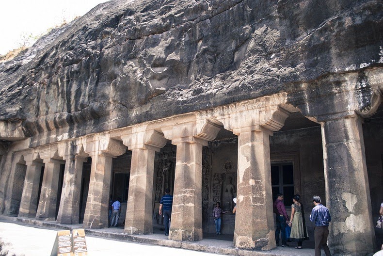
Ajanta and Ellora are two monumental rock cut caves that define Indian art and architectural accomplishment. Though these two monuments are separated by a distance of approximately 100 kilometers they are often mentioned together since their aesthetics and importance are at par and the fact that both are situated in the Aurangabad district of Maharashtra. While Ajanta is mostly about beautiful paintings made on cave walls on the theme of Buddhism, Ellora is all about sculpture and architecture belonging to three different religions of those times, prevailing in the country - Buddhism, Hinduism and Jain.


Ajanta Caves


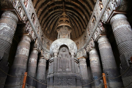
Ajanta is a cluster of 30 caves of different sizes excavated in a horse shoe shaped stretch of rock embedded in a hill facing a narrow stream called Waghora. Each cave was connected to the stream by a flight of steps, which are now demolished with few remnants left behind. These caves are named after a nearby village called Ajanta. It includes masterpiece paintings of Buddhist religious art, with figures of the Buddha and depictions of the stories that tell about the previous lives of the Buddha.

The caves were built in two phases starting around the 2nd century BC, with the second group of caves built around 400–650 AD. Buddhist Monks used to retreat to this serene place during the monsoon, and as they had plenty of time during such retreats they used it for deepening their religious quest through prayer and discussion.

There were two types of caves- Vihara and Chaitya griha. Viharas are monasteries used for living and prayer. These are square halls with small cells along the side walls. These cells were used by the monks for rest and other activities while the central larger square space was for prayer. The front of the vihara is often marked by a colonnaded porch, with another space inside the doors running parallel to the porch. The other types of cave, Chaityagrihas, are halls used for prayers. These are long tunnel like caves with round pillars on both sides. At the end of the cave is placed the stupa, which is a symbol of Lord Buddha.

These caves were abandoned twice. First for a period of nearly 300 years, because the local population had turned mainly Hindu. The caves and its excavation became vibrant again with the succession of the Emperor Harishena of the Vakataka Dynasty but again disrupted by Harisena's death in 477 AD. This time it waited for almost 1,000 years till John Smith, a British officer for the Madras Presidency, accidentally discovered the entrance to Cave No. 10, on 28 April 1819, while hunting tiger. John actually vandalized the walls with his name and date, although this is far from normal eye sight now, as when he wrote it, he was standing on some five foot high rubble that collected itself over hundreds and hundreds of years.


Ellora Caves
Ellora Caves comprises of 34 monasteries and temples, dug side by side in the wall of a high basalt cliff, extending over more than 2 km. The caves were built during the 5th to the 10th century, and represents one of the finest examples of Indian rock-cut architecture.

Ellora has cave temples devoted to Hindu, Buddhist and Jain. The Buddhist caves were one of the earliest structures, created between the 5th and 8th centuries. These structures consist mostly of viharas or monasteries, which were large, multi-storeyed buildings carved into the mountain face, including living quarters, sleeping quarters, kitchens, and other rooms. The most famous Buddhist cave is the Vishwakarma cave, popularly known as carpenter cave.


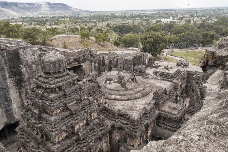
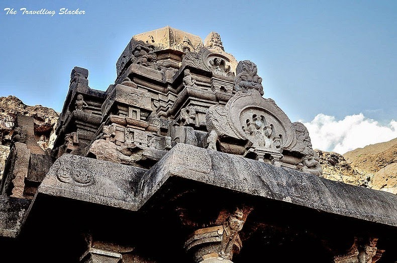
The Hindu caves were constructed between the middle of 6th century to the end of the 8th century. These caves represent a different style of creative vision and execution skills. Some were of such complexity that they required several generations of planning and co-ordination to complete. The highlight of the all the Hindu caves is the Kailasha, designed to recall Mount Kailash, the abode of Lord Shiva. It looks like a freestanding, multi-storeyed temple complex, but it was carved out of one single rock, and covers an area double the size of Parthenon in Athens. The Kailasha alone took hundred years to get completed.

The Jain caves belong to the last phase of construction at Ellora. The Jain caves are smaller in size but contain some intriguing and detailed art work. Be it the beautifully carved pillars of the Indrasabha, the lotus on its ceiling or the exceptional shrine called chota kailasha or the sculptures of Yakshini and Durga.


Source
READ MORE»

The Largest Waterfall That No Longer Exist

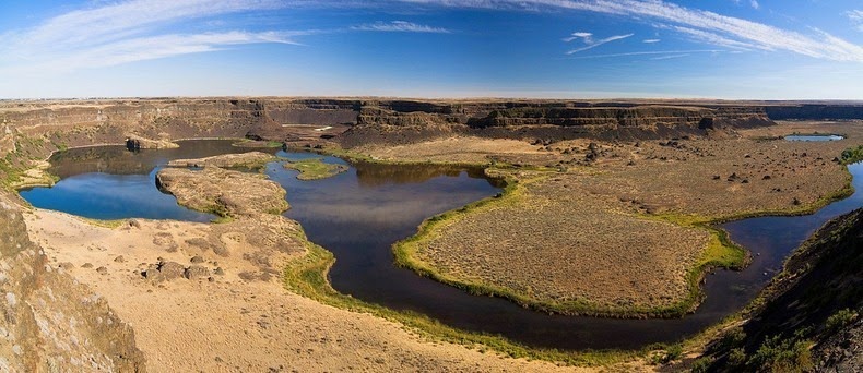
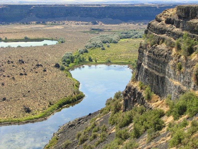
Located in central Washington, on the opposite side of the Upper Grand Coulee from the Columbia River, is a 3.5-mile long and 400-foot high scalloped precipice known as Dry Falls. As the name suggests, Dry Falls no longer carries water, but at one time, it was once the largest waterfall that is known to have existed on earth. It is five times the width of the Niagara falls and more than twice its height. It is speculated that during the last ice age, catastrophic flooding channeled water at 65 miles per hour through the Upper Grand Coulee and over this 400-foot rock face. At this time, it is estimated that the flow of the falls was ten times the current flow of all the rivers in the world combined.


Nearly twenty thousand years ago, as glaciers moved south through North America, an ice sheet dammed the Clark Fork River near Sandpoint, Idaho. Consequently, a significant portion of western Montana flooded, forming the gigantic Lake Missoula. Water covering three thousand square miles of northwest Montana, about the volume of Lake Ontario, was locked behind this glacial dam. Eventually, rising water in lake Missoula broke through the ice dam creating a cataclysmic flood that spilled into Glacial Lake Columbia, and then down the Grand Coulee. The massive torrent (known as the Missoula Flood) ran wild through the Idaho panhandle, the Spokane River Valley, much of eastern Washington and into Oregon, flooding the area that is now the city of Portland under 400 feet of water. The tremendous force of the Dry falls eroded away so much earth and rock, that the precipice fell back by 15 miles to its present position.

Once the ice sheet that obstructed the Columbia melted, the river returned to its normal course, leaving the Grand Coulee and the falls dry. Today, this massive cliff can be viewed from the Dry Falls Interpretive Center, part of Sun Lakes State Park, and located on Route 17 near the town of Coulee City.

It is generally accepted that this process of ice-damming of the Clark Fork, refilling of Lake Missoula and subsequent cataclysmic flooding happened dozens of times over the years of the last Ice Age.


Source
READ MORE»

10 Forgotten Advanced Civilizations

Prehistory literally means the time “before we had written records” (roughly the time before the 4th Century BC) and ancient history is the time since our recorded history. Our concept of ancient history was originally firmly determined by the bible. Written from an insular point of view, the histories of some ancient cultures were distorted, badly neglected or even omitted. The existence of inexplicable monuments, certain man-made marvels and archaeological finds pertaining to our ancient- and prehistory, are leading more and more archaeologists to believe long forgotten advanced civilizations existed. As most of our ancient records were lost during the destruction of the great libraries, the following genuine mysteries are the only remnants of their existence.


10. Ancient Devices

Ancient knowledge was a lot more refined and developed than we have been taught hitherto. From batteries to planispheres, an assortment of gadgets have been excavated and found. Two notable finds were the Nimrud lens and the famous Antikythera Mechanism. The 3,000 year old Nimrud lens was discovered at the palace of Nimrud, in Iraq. Some experts believe the lens was part of an ancient telescope the Babylonians used, hence their advanced knowledge of astronomy. And the famous Antikythera Mechanism (200 BC.) was created to calculate the movements of the sun, moon and planets to predict celestial events. Unfortunately, we can only speculate on the ways many of these devices were created, used and why the ancient knowledge pertaining to them disappeared for millennia afterwards.


9. The Rama Empire

Despite wars and several invasions, India’s ancient history was largely preserved. Long believed to date from about 500 BC.; discoveries in the past century have pushed back the origins of Indian civilization thousands of years. In the Indus Valley, the cities of Harappa and Mohenjo Daro were discovered. The cities were so sophisticated and well-planned, that archaeologists believe they were conceived as a whole before construction on them begun. The Harappa culture also remains an enigma. Its origins and deterioration is hidden, its dialect is unknown and the writing is completely indecipherable. At the site no differences in social class can be discerned and there are no temples or religious buildings. No other culture, including those of Egypt and Mesopotamia, has revealed the same degree of planning and development.


8. The Longyou Caves

Considered by the Chinese to be the “Ninth Wonder of the Ancient World”, the origin of the 24 caves thus far uncovered is an unfathomable mystery. Discovered in 1992, no historical record or evidence of the work involved to excavate the almost million cubic meters of stone exists. The chiseling was done in such a way that it left a consistent pattern throughout the caves which some experts believe to be symbolic. The patterns are similar to those found on pottery that has been dated between 500 and 800 BC. Stone carvings and pillars can be viewed in the cave that has been opened up for public viewing. There is also a rumor that seven of the caves have a distribution pattern that matches the seven stars of the Big Dipper.


7. Nan Madol

Off the island of Pohnpei in Micronesia, lies the ancient city of Nan Madol. Built on a coral reef exclusively from colossal basalt rocks (some weighing up to 50 tons), the city is intercrossed by a multitude of canals and connected via submerged tunnels. Its scale has been compared to the Great Wall of China and the Great Pyramid, even though the Pyramid-stones only weigh about 3 tons each. No records exist as to who built the city, when it was built or for what reason. Radiocarbon dating has placed its construction in 200 BCE. The origin of the basalt rocks that make up the city is unknown, as is the methods used to transport them there and stack them as high as 50 feet, and as thick as 17 feet. Human bones uncovered by archaeologists are remarkably larger than the local Micronesians of the area today.


6. The Stone Age Tunnels

From Scotland to Turkey, underneath hundreds of Neolithic settlements, archaeologists have uncovered evidence an extensive network of underground tunnels. From almost 2, 300 feet (700 m) in Bavaria Germany to 1, 200 feet (350m) in Austria, the fact that these tunnels survived for 12, 000 years is a testimony to the skill of the builders and of the sheer size the original network must have been. Even though they do not all link up, experts believe people used these tunnels to travel safely regardless of which danger they were facing. Throughout the system there also appears to be storage rooms and seating.


5. Pumapunku and Tiwanaku

Puma Punku is one of four structural arrangements in the ancient Pre-Inca city of Tiwanaku in South America. The age of the megalithic ruins is extremely controversial as they have been prodded, excavated, and looted since they were discovered and as such, experts say they have been contaminated in every way possible. The consensus is that they are older than the pyramids, with claims of up to 15, 000 years. Even the Incas didn’t know its history. The massive stones used in the construction bear no chisel marks and were finely cut to interlock with the others. A lot of the stones were cut so precisely that the builders clearly had an extremely sophisticated knowledge of stone-cutting, engineering and geometry. The city also had a functioning irrigation system, waterproof sewage lines and hydraulic mechanisms. With no record of its inhabitants or their methods, the technologies and processes used during its construction remains an enigma to experts.


4. Metal Cramps/Clamps

Continuing the mystery of Pumapunku; at this site as well as those of Koricancha, Ollantaytambo, Yuroc Rumi and in ancient Egypt, metal clamps were used in their largest structures. Evidence of the grooves and holes in which they were used can still be observed. At first archaeologists believed that clamps were brought to these grooves to be placed, but recent scans have revealed that metal was poured into these indentations, which means the builders had portable smelters. It is said that the metals used could only be melted at very high temperatures; temperatures the ancients (to our knowledge) were not capable of. One has to wonder why this technology as well as the incredible methods used to build these megalithic ruins became lost in the immediate centuries afterwards. A technology developed continues to fan out, but a less advanced civilization will lose the technology in time if they have not acquired the essentials.


3. The Baalbek Enigma

The archaeological site of Baalbek in Lebanon has some of the most well-preserved Roman ruins in the world. Called Heliopolis in ancient times, the temple ruins are truly amazing to behold. What makes this site mysterious though, is the massive megalithic ruin mound upon which the Romans built. Making the their ruins look pale in comparison, these monoliths that can weigh up to 1, 200 tons each are the largest worked slabs of stone in the world. Some archaeologists believe that the history at the site goes back about 9000 years, as excavations have revealed Middle Bronze Age (1900-1600BC) and Early Bronze Age (2900-2300 BC) evidence on top of each other. Apart from the mystery as to how these stones were brought to the site from where they were quarried; given the site’s location and the space available to maneuver, architects and engineers claim that we have no known lifting technologies available to us today, that can lift and position these stones. They are simply beyond the construction capabilities of any accepted ancient or modern-day builders.


2. The Giza Plateau

Volumes have been written on the mysteries of ancient Egypt. We now know that the Great Pyramid’s construction was so accurate and beyond comprehension that it was probably never meant to house a king’s remains. Furthermore, as it has been proven that the Sphinx’s erosion came mainly from rainfall before the area became a desert, it is at least 7, 000 – 9, 000 years old with some believing it could even be older than that. The sudden rise of the Egyptian civilization in the 3rd millennium BC has lead many experts to believe that theirs were a legacy of an earlier, forgotten civilization. Apart from the Sphinx, further pre-dynastic construction is evident in Khafre’s Mortuary and Valley Temples, and Menkaure’s Mortuary Temple as they were built from limestone blocks excavated during the Sphinx’s construction and has the same evident erosion.


1. Gobleki Tepe

Dating back to the end of the last ice age (12, 000 years ago), the recently discovered temple complex in south-eastern Turkey has been called the most important archaeological discovery of modern times. Predating pottery, writing, the wheel and metallurgy; its construction implies a level of sophistication and complexity thus far not associated with Palaeolithic civilizations. With a construction date thousands of years earlier than Stonehenge, the site consists of 20 round structures (4 have been excavated so far) and elaborately carved pillars up to 18 feet tall and weighing up to 15 tons each. Nobody can say with any certainty who created the site, or why, but one has to wonder how these supposed hunter-gatherers had advanced knowledge of masonry and stonework if they were the first civilization…


Source
READ MORE»