Very interesting and somewhat dangerous airports are those located on an artificial islands and atolls. Artificial island airports are constructed in waters close to land, serving regions where available land is scarce and population density is high. Atoll airports are located on small coral islands and are usually associate exotic island countries with the world's greatest cities, so they are mainly used by tourists.
1. Ibrahim Nasir International Airport, Maldives

Ibrahim Nasir International Airport, more commonly known as Malé International Airport, previously known as Hulhulé Airport, is the main international airport in the Maldives. It is located on Hulhulé Island in the North Malé Atoll, nearby the capital island Malé.

Today, Ibrahim Nasir International is well connected with major airports around the world, mostly serving as the main gateway into the Maldives for tourists. Moreover, despite the upgrading of Gan Airport to international standard, Ibrahim Nasir International is currently the only internationally active airport in the country.

On 26 July 2011, Male' International Airport was officially renamed as 'Ibrahim Nasir International Airport' in memory of Ibrahim Nasir, 2nd President of the Maldives. He is known for initiating the airport in 1960.
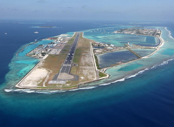
The airport resides at an elevation of 6 feet (2m) above mean sea level. It has one runway with an asphalt surface measuring 3,200 m × 45 m (10,499 ft × 148 ft).
2. Chūbu Centrair International Airport, Japan

Chūbu Centrair International Airport is an airport on an artificial island in Ise Bay, Tokoname City in Aichi Prefecture, 35 km (22 mi) south of Nagoya in central Japan.

Airport is classified as a first class airport and is the main international gateway for the Chūbu ("central") region of Japan. Chūbu is Japan's third off-shore airport, after Nagasaki Airport and Kansai International Airport, and is also the second airport built in Japan on a manmade island. There are currently 5 offshore airports in Japan, including Kobe Airport and Kitakyushu Airport.

The main terminal is shaped like a "T," with three piers radiating from a central ticketing area. This design keeps check-in distances below 300 m (980 ft). Originally, designers planned to make the main terminal resemble an origami crane from above, but this plan was abandoned due to cost.

Some 11,721,673 people used the airport in 2006, ranking 8th busiest in the nation. 273,874 tons of cargo was moved in 2005. For the fiscal year ending in March 2011, the above figures have dropped considerably to 9.06 million passengers.

Combined international and domestic cargo figures totaled just 151,000 tons for the same year, a dramatic drop that can be largely blamed on the substantially weakened manufacturing economy since the fall of 2008 in the Aichi region.
3. Maamigili Airport, Maldives

Maamigili Airport is located on the island of Maamigili in Alif Dhaal Atoll (also known as Ari Atholhu Dhekunuburi) in the Maldives and was opened on 1st October 2011.

The airport resides at an elevation of 6 feet (2m) above mean sea level. It has one runway with a concrete surface measuring 1,800 by 30 metres (5,906 ft × 98 ft).
4. Kobe Airport, Japan

Kobe Airport is an airport on an artificial island just off the coast of Kobe, 8 km (5.0 mi) south of Sannomiya Station Japan. It primarily handles domestic flights, but can also accommodate international charter flights.

In the first year of operation (2006) the airport handled 2,697,000 passengers with an average load factor of 61.1%. In FY 2010 it handled 2,215,000 passengers with an average load factor of 69.2%.

Some international charter flights also use Kobe Airport. Although the airport's runway is not long enough to handle long-range flights to Europe and the Americas, it occasionally handles charters to China and other nearby countries.

The Transport Ministry has banned "scheduled international charters" and has capped scheduled domestic operations at 30 daily flights in order to prevent overcrowding in the area's airspace and to protect the growth of Kansai Airport. The flight caps have been a point of controversy with Kobe Airport supporters, who point out that the cap was calculated based on Kansai Airport operating twice as many frequencies as are currently offered: given the current traffic levels at Kansai, Kobe should be able to handle six or seven flights per hour.
5. Hong Kong International Airport, China

Hong Kong International Airport is the main airport in Hong Kong. It is located on the island of Chek Lap Kok, which is largely reclaimed for the construction of the airport itself. The airport is also colloquially known as Chek Lap Kok Airport, to distinguish it from its predecessor, the closed Kai Tak Airport.

The airport has been commercially operational since 1998, replacing the former Kai Tak Airport, and is an important regional trans-shipment centre, passenger hub and gateway for destinations in Mainland China (with over 40 destinations) and the rest of Asia. The airport is currently the world's busiest cargo gateway and one of the world's busiest passenger airports.

It is a focus city for many airlines, including China Airlines and China Eastern Airlines, which serves 18 flights to Hong Kong per day (one direction) from 15 cities. Virgin Atlantic, United and Air India use Hong Kong as a stopover point for flights respectively from London to Sydney, from Tokyo to Singapore and Ho Chi Minh City as well as from India to Osaka and Seoul.
6. Henderson Field, USA

Henderson Field is a public airport located on Sand Island in Midway Atoll, an unincorporated territory of the United States. The airport is used as an emergency diversion point for ETOPS operations. It still serves this capacity, most recently in June 2011 and again in July 2012.

Henderson Field is an uncontrolled airport (no tower). Flight arrivals and departures are typically limited to night during the months of October - August when albatross are present (Midway Atoll is the world's largest nesting albatross colony).
7. Kitakyushu Airport, Japan

Kitakyushu Airport is an airport in Kokuraminami-ku, Kitakyushu, Fukuoka Japan. It is built on an artificial island in the western Seto Inland Sea, 3 km (1.9 mi) away from the main body of the city. It opened on March 16, 2006, as New Kitakyushu Airport but was renamed in 2008. It is designated a second class airport, and it has some international charter flights.

The runway is 2,500 by 60 m (8,202 by 197 ft) (with a separate taxiway of 2,500 by 30 m (8,202 by 98 ft)), enough to accommodate Boeing 747s and other large jet aircraft. The manmade island on which the airport is built is 4,125 m (13,533 ft) long and 900 m (2,953 ft) wide (3.73 km2 (1.44 sq mi)). Due to the island's size and the relative shallowness of the surrounding water, about 7 m (23 ft), future expansion is possible.
8. Macau International Airport, China

Macau International Airport is situated at the eastern end of Taipa island and neighbouring waters, is the only airport in Macau, which opened for commercial operations in November 1995.

The airport's runway was built on a strip of reclaimed land in the sea, adjacent to Taipa Island, where the main terminal and air traffic control facilities are located. The runway is connected to the apron by two causeways.
 Runway at the moment of construction link
The airport's designed capacity is 6,000,000 passengers per year, with processing capacity of up to 2,000 passengers per hour. The airport does not have a night curfew. There are 24 parking spaces for aircraft in the apron, with 4 jetways.
 Airplane used causeway to reach the runway located on an artificial island
Despite its small physical size, the airport is capable of handling Boeing 747s and Antonov 124s, which forms a vital freight link between local manufacturers and overseas markets. Its catering facility can produce up to 10,000 meals per day.
9. Kansai International Airport, Japan

Kansai International Airport is an international airport located on an artificial island in the middle of Osaka Bay, 38 km (24 mi) southwest of Ōsaka Station, located within three municipalities, including Izumisano (north), Sennan (south), and Tajiri (central), in Osaka Prefecture, Japan. The airport is off the Honshu shore. The airport serves as an international hub for All Nippon Airways, Japan Airlines, and Nippon Cargo Airlines, and also serves as a hub for Peach, the first international low-cost carrier in Japan. It is colloquially known as Kankū in Japanese.

Construction started in 1987. The sea wall was finished in 1989 (made of rock and 48,000 tetrahedral concrete blocks). Three mountains were excavated for 21,000,000 m3 (27,000,000 cu yd) of landfill. 10,000 workers and 10 million work hours over three years, using eighty ships, were needed to complete the 30-metre (98 ft) layer of earth over the sea floor and inside the sea wall. In 1990, a three kilometer bridge was completed to connect the island to the mainland at Rinku Town, at a cost of $1 billion.

The island had been predicted to sink 5.7m (19 ft) by the most optimistic estimate as the weight of the material used for construction compressed the seabed silts. However, by this time, the island had sunk 8.2m (27 ft) - much more than predicted. The project became the most expensive civil works project in modern history after twenty years of planning, three years of construction and several billion dollars of investment.

Much of what was learned went into the successful artificial islands in silt deposits for New Kitakyushu Airport, Kobe Airport, and Chūbu Centrair International Airport. The lessons of Kansai Airport were also applied in the construction of Hong Kong International Airport.
10. Nagasaki Airport, Japan

Nagasaki Airport is an international airport located 4 km (2.5 mi) west of the railway station in the city of Ōmura and 18 km (11 mi) north northeast of the Nagasaki railway station in the city of Nagasaki, Nagasaki Prefecture, Japan. The airport terminal and runway are on an island, and the shorter runway is on the mainland.

The current island runway and terminal opened on May 1, 1975. Although Nagasaki is superficially similar to Japan's other island airports, Kansai International Airport, Kobe Airport, Kitakyushu Airport, and Chūbu Centrair International Airport, Nagasaki's island existed (in a radically different shape) before the airport was constructed. Constructing the airport required flattening the island's hills and forming landfill around its shore, expanding it from 0.9 to 1.54 km2 (0.35 to 0.59 sq mi).
11. Marshall Islands International Airport, Marshall Islands

Marshall Islands International Airport, also known as Amata Kabua International Airport, is an airport located in the western part of Rairok on the south side of Majuro Atoll, the capital of the Republic of the Marshall Islands. The airport was built sometime after World War II (1943) on Anenelibw and Lokojbar islets. It replaced Majuro Airfield a coral-surfaced airstrip at Delap Island near the eastern end of Majuro Atoll that had been originally constructed by Japanese occupation forces in 1942.

A series of single floor structures (small hangars) makeup the airport terminal. No physical structures existed at the airport prior to the 1970s. The current terminal structure and modern runway/apron were built in 1971. Passengers from flights arriving at the airport use stairs to exit aircraft and walk to the terminal.
Source