Oil Recovery Ship That Splits Into Two

The German Navy operates a ship of an interesting design, engineered to recover oil spilled into the sea. The Bottsand-class oil recovery ship, also known as a split hull oil recovery vessel, can split along its length to scoop oil contaminated water into its 790 cubic meter recovery tank. The twin hull ship feature a unique bow which can be opened by 65 degrees. This creates an area of more than 40 square meters to collect oil-polluted seawater. The water is pumped into the ship's tank, where it can be cleaned and the oil separated. The ship can clean up to 140 square meters of ocean surface polluted with a 2 mm oil slick in an hour.

The two ships in the class entered service in 1984 and 1987, and are used to contain oil spills from German ships in the sea. Although owned by the German Navy, the ships are manned by civilians and not naval personnel.


Source
READ MORE»

Top 6 Incredible Drives Above the Trees

Have you ever had the opportunity to drive above trees? Many highways passing through the forests, but there are only a few who pass above them. The construction of these sections of highways is certainly expensive, but their significance for the environment is very high: noise reduction, protection of animals and trees.


1. Rodovia dos Imigrantes Highway Viaducts, Brazil


The Rodovia dos Imigrantes (SP-160) crossing the Serra do Mar in São Paulo State, Brazil.


The original highway was built as a single carriageway in 1986, and a second carriageway was added in 2002.


Advanced technology allowed for a more modern design and a dramatic reduction in deforestation during construction.


The complex terrain the motorway overcomes turned it into a worldwide reference


A view of the north and south carriageways of Rodovia dos Imigrantes, one crossing over the other


High strutting six-lane bridges seemingly floating over the tropical rain forest which covers the steep faces of the Serra do Mar, the 800m (2,625 ft) high cliff range which separates the São Paulo plateau from the seaside lowlands.


2. Interstate H-3 Highway Viaducts, Hawaii, USA


Also known as the "John A. Burns Freeway". This 16-mile (26km) road is a beautiful engineering feat.


It cost almost $100-million per mile to build and took 37 years to complete--20 years of that time was taken doing environmental impact studies. But the results are fantastic.


This view show the highway coming out of the tunnel on the east side of the Koolau Mountains.


Viaducts of H-3 within Halawa Valley


3. Europabrücke or Europe's Bridge, Austria


Europabrücke, or Europe's bridge, is a 777-metre (2,549 ft) long bridge spanning the 657-metre (2,156 ft) Wipp valley just south of Innsbruck, Tirol, Austria.


The A13 Brenner Autobahn (and European route E45) passes over this bridge, above the Sill River, forming part of the main route from western Austria to Italy via South Tyrol across the Alps


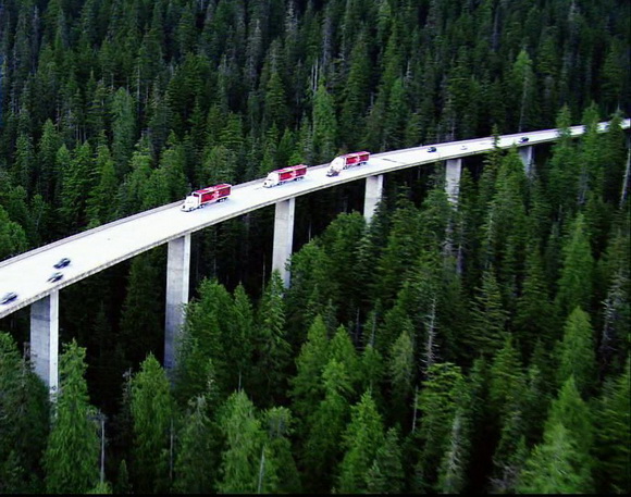
4. Denny Creek Viaduct, USA


Denny Creek Viaduct is located in U.S. state of Washington.


Denny Creek is the most family-friendly trail in the region. Above this trail crosses the highway I-90, and thanks to its height in relation to the ground, makes minimal noise in the environment.


5. Linn Cove Viaduct, USA


This 1243-foot (380 m) concrete segmental bridge on the Blue Ridge Parkway snakes around the slopes of Grandfather Mountain in North Carolina.


It was completed in 1987 at a cost of $10 million and was the last section of the Blue Ridge Parkway to be finished. It was created to minimized destruction of Grandfather Mountain; rather than going through the mountain, they built this bridge to go around it.


Travel brochures always say that the Linn Cove Viaduct has amazing fall colors.


6. Du Toit Viaduct, South Africa


Du Toit Viaduct is situated in the Western Cape province of South Africa, on the Regional road R101 between Paarl and Worcester.


Source
READ MORE»

White Pocket in Vermillion Cliffs National Monument

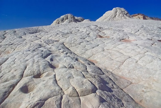
The White Pocket is an isolated, notoriously hard-to-reach patch of sandstone hidden within the desert expanse of Vermillion Cliffs National Monument near the Arizona/Utah border. The entire area is covered in a gray rocky layer, sometimes only a few centimeters thick, above the red sandstone where the formations heave and drip that makes the entire landscape look like as if it was covered with icing sugar. In some spots the stone layers are completely twisted, just like an enormous marble cake.

The extraordinary geology at White Pocket is not easily explained. Some geologist proclaim that White Pocket is a result of “soft sediment deformation”, meaning the contortions and twisting and turning at White Pocket occurred back in Jurassic time while the sand was saturated and before the sand was completely turned into rock.


According to one retired petroleum geologist Marc Deshowitz, who studied White Pocket more than anyone else, believes the landscape was the result of a huge sand-slide mass, triggered by an earthquake, detaching from a tall dune and traveling rapidly downslope. As the mass slid and tumbled downslope, it ripped up chunks of laminated sand beneath that intermixed with the basal part of the slide. The sand mass eventually filled a large pond or oasis. This large sand mass is the featureless bleached-white sandstone or "cauliflower rock" seen today. The instantaneous loading from the sand mass caused pressure adjustments within the underlying saturated sand resulting in contortions and fluid escape structures such as sand volcanoes. Marc has identified at least 25 of these features supporting his theory.

The fine laminae and cross-beds beneath the slide mass are remarkably well-preserved. This may indicate all of the sand involved was buried under a fairly thick column of additional sediment. In other words, the slide plane may have been several 100 feet below the surface. This overburden pressure would have allowed the plastic-like contortions but still keep things somewhat in order.

Only a year ago, White Pocket was relatively obscure, formerly known only by local ranchers and a handful of adventurous photographers. Then National Geographic ran a story on the Vermilion Cliffs National Monument, which included some excellent photos of White Pocket. Since the magazine’s release there has been a surge of activity at White Pocket. Today, White Pocket is in the bucket list of every hiker and outdoor enthusiast.


Source
READ MORE»

Hibaku Jumoku - The Trees That Survived Hiroshima

After the atomic bombing of Hiroshima on 6th August 1945, with landscapes demolished, soils charred and radiation rampant, Dr. Harold Jacobsen, a scientist from the Manhattan Project, told the Washington Post that Hiroshima will be barren of life and nothing will grow for 75 years. But nature had other plans. The following spring, to everyone's surprise and delight, new shoots were seen springing up amongst the debris of the city. Those new saplings provided a powerful message to the survivors of the atomic bomb and gave them hope that they could rebuild their city.

Today, over six decades after the atomic bomb, Hiroshima is a green and vibrant modern city. Many of the trees that were planted in the city after the war were gifts from overseas donors and donors from other parts of Japan. However, hundreds of trees that are still standing today were actually around the vicinity when the bomb went off. Though broken and badly charred, they survived and soon were healthy again.


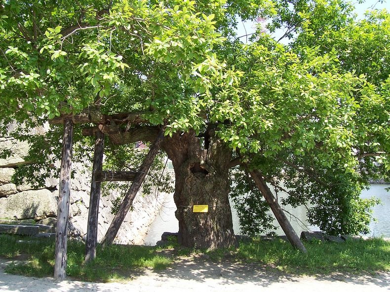
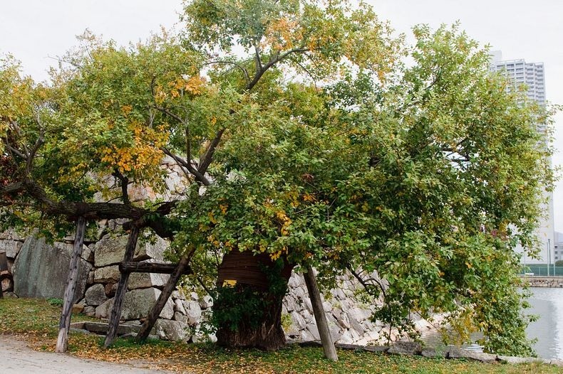
After the war, many of those trees were preserved in 55 locations within a 2km radius of the hypocenter. Today, they are officially registered as A-bombed trees. Each A-bombed tree is called a "Hibaku Jumoku" - survivor tree, and is identified by a name plate. According to the City of Hiroshima, there are about 170 survivor trees representing 32 different species.

The tree closest to the hypocenter is a Weeping Willow, which stands 370 meters away from the blast. Although the original tree was toppled by the bomb, its roots survived and new buds sprouted at the base. Another Weeping Willow stands near Seishonen and the Baseball Stadium, 450 meters away from ground zero. A partial list of A-bomb survivors can be found on www.lang-arts.com/survivors/index.html.

The trees are located all over on the grounds of public buildings, temples, and shrines, and are under the care of the Hiroshima government. Seeds and seedlings from A-bombed trees are shared by the city and Hiroshima citizens with people in Japan and overseas, and these new trees are now growing in places all over the world.


One of the two pillars of the Sanno Shrine Torii was toppled by the A-bomb blast. The blast also blew away the branches and leaves of the two camphor trees in the precincts of the Shrine, which were then more than 500 years old. At that time, it was feared that the trees might wither and die; however, they gradually began to recover, and now are thickly covered with leaves and branches.


Effect of the blast on a plant


Source
READ MORE»

Top 11 Unusual Caves in the World

A cave or cavern is a natural underground space large enough for a human to enter. Caves form naturally by the weathering of rock and they often extend deep underground. Because of their uniqueness and beauty, some caves have become very interesting places for tourists and photographers worldwide.


1. Sea Cave in Algarve, Portugal


This beautiful sea cave is located near Benagil Beach in the Algarve region of Portugal. As you can see the bottom of the cave is covered with fine sand, and on the roof there is a "window to the sky".


2. Crystal Cave, Iceland


This cave in the glacier ice is the result of glacial mill, or Moulin where rain and melt water on the glacier surface are channeled into streams that enter the glacier at crevices. The waterfall melts a hole into the glacier while the ponded water drains towards lower elevations by forming long ice caves with an outlet at the terminus of the glacier.


The fine grained sediments in the water along with wind blown sediments cause the frozen meltwater stream to appear in a muddy colour while the top of the cave exhibits the deep blue colour. Due to the fast movement of the glacier of about 1 m (3 ft) per day over uneven terrain, this ice cave cracked up at its end into a deep vertical crevice, called cerrac. This causes the indirect daylight to enter the ice cave from both ends resulting in homogeneous lighting of the ice tunnel.


The cave is accessible through a 22-foot (7 m) entrance on the shoreline. At the end it tapers to a tight squeeze no more than four feet high (1,2 m). Ice caves are in general unstable things and can collapse at any time. They are safe to enter only in winter when the cold temperatures harden the ice. Even so one could hear constant cracking sounds inside the cave. It was not because it was going to collapse but because the cave was moving along with the glacier itself. Each time the glacier moved a millimeter loud sounds could be heard.


3. Devetashka Cave, Bulgaria


Devetashka cave is one of the biggest caves in Bulgaria but it is most famous for its amazing history. It is also currently home to nearly 30,000 bats.


The man on the floor of the Devetashka cave

Devetashka cave is located 18 km (11mi) northeast of Lovech and 2 kilometers (1.2mi) away from the village of Devetaki. The cave is also known as Maarata or Oknata for its seven different-sized holes in the ceiling, through which sunlight penetrates and illuminates the central hall and part of its two fields.


Old building inside of entrance area

The entrance of the cave is 35 meters (115ft) wide and 30 meters (100ft) high. About 40 meters (130ft) after the entrance, the cave widens, forming a spacious hall with an area of 2,400 sqm (0.6 acres). The height of the hall is 60 meters (197ft); at some places it reaches 100 meters (330ft).


4. Glow Worm Caves, New Zealand


Waitomo, New Zealand is famous for one thing. Every year, heaps upon heaps of travelers come here to see the infamous glow worms that line the ceilings of the nearby caves. The glow worms emit a phosphorescent glow that shines from the roofs of the caves like a starry night.


The interesting thing about the glow worms is that they aren’t really glow worms. They’re fly larvae. And what glows? Well, that’s their waste and snot. The larva glow to attract prey into its threads by making the prey believe they are outdoors as the roof of a cave looks much like a starry night. Hungry larva glow brighter than ones that have just eaten. There are a couple of ways to see the glow worms. There’s the three hour black water tubing trip, the five hour trip that includes abseiling and climbing, or, if you like it easy, a boat.


5. Cueva de Arpea, Spain


Cueva de Arpea is located below the twisted rock layers in Aezkoa valley in northern Spain. That area is home to some truly amazing caves.


The cave is called in french "caverne d'harpea". It's believed to have been used as a refuge by ancient shepherds since old times.


6. Minnehaha Falls Cave, USA


Near where the Minnehaha Creek meets the Mississippi River, a 53 ft (16m) waterfall that freezes during the winter creates a temporary cave behind a wall of ice. Due to the extremely cold temperatures in the area during the winter months, the falls freeze, creating a dramatic cascade of ice that can last well into the spring.


Minnehaha Creek is located in Hennepin County, Minnesota that extends from Lake Minnetonka in the west and flows east for 22 miles through several suburbs west of Minneapolis and then through south Minneapolis. Including Lake Minnetonka, the watershed for the creek covers 181 square miles.


The creek might have been unremarkable except for the 53 foot (16m) Minnehaha Falls located near the creek's confluence with the Mississippi. The site is not far from Fort Snelling, one of the earliest white settlements in the region.


7. Fingal's Cave, UK


Fingal's Cave is a sea cave on the uninhabited island of Staffa, in the Inner Hebrides of Scotland, part of a National Nature Reserve owned by the National Trust for Scotland. It is formed entirely from hexagonally jointed basalt columns.


Its size and naturally arched roof, and the eerie sounds produced by the echoes of waves, give it the atmosphere of a natural cathedral. The cave's Gaelic name, An Uaimh Bhinn, means "the melodious cave".


The cave has a large arched entrance and is filled by the sea. Several local companies include a pass by the cave in sightseeing cruises from April to September. However, it is also possible to land elsewhere on the island and walk to the cave overland, where a row of fractured columns forms a walkway just above high-water level permitting exploration on foot.


8. Giant Crystal Cave, Mexico


Cave of the Crystals or Giant Crystal Cave is a cave connected to the Naica Mine 300 metres (980 ft) below the surface in Naica, Chihuahua, Mexico. The main chamber contains giant selenite crystals (gypsum, CaSO4·2 H2O), some of the largest natural crystals ever found.


The cave's largest crystal found to date is 12 m (39 ft) in length, 4 m (13 ft) in diameter and 55 tons in weight. The cave is extremely hot with air temperatures reaching up to 58 °C (136 °F) with 90 to 99 percent humidity. The cave is relatively unexplored due to these factors. Without proper protection people can only endure approximately ten minutes of exposure at a time.


A group of scientists known as the Naica Project have been heavily involved in researching these caverns.


9. Cenote Ik Kil, Mexico


Ik Kil is a well known cave with no roof, or a sinkhole outside Pisté in the Municipality of Tinúm, Yucatán, Mexico, It is located in the northern center of the Yucatán Peninsula and is part of the Ik Kil Archeological Park near Chichen Itza. It is open to the public for swimming and is often included in bus tours.


This cave is open to the sky with the water level about 26 metres (85 ft) below ground level. There is a carved stairway down to a swimming platform. Ik Kil is about 60 metres (200 ft) in diameter and about 40 metres (130 ft) deep. There are vines which reach from the opening all the way down to the water along with small waterfalls. Also, there are black catfish which swim in the sinkhole.


10. Blue Lake Cave, Brazil


Mato Grosso do Sul region in Brazil (and especially the quiet town of Bonito) boasts many marvelous underground lakes: Gruta do Lago Azul, Gruta do Mimoso, Aquário Natural. The world famous "Gruta do Lago Azul” (Blue Lake Cave) is a natural monument whose interior is formed by stalactites, stalagmites and a huge and wonderful blue lake.
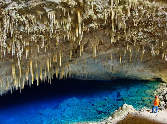


The beauty of the lake is something impressive. The Blue Lake Cave has a big variety of geological formation but impresses mainly for the deep blue colored water of its inside lake.


11. Blue Marble Caves, Chile


In Patagonia, South America, General Carrera Lake is shared by Argentina and Chile. But on the Chilean side of the beautiful emerald-green to turquoise-blue waters, there are breathtakingly beautiful marble caves carved into passageways and caverns.


These amazing marble formations were sculpted by erosion into three main marble formations: La Capilla (the Chapel), El Catedral (the Cathedral), and La Cueva (the Cave).


The impressive labyrinth of marble caves are large enough for a small boat to glide into.


Source
READ MORE»